First arrival of the season (that is a full route, starting from a coastal start point).
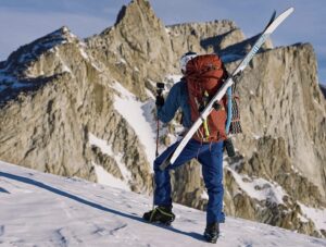
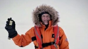
(Correne Coetzer) Henry Worsley arrived at the Geographic South Pole on January 2, 2016, Day 51 of his solo, unassisted unsupported Antarctic traverse. He started at Berkner Island on November 13 and covered an accumulated distance of 571.5 nautical miles (1058.4 km). This is the end of Phase 1, Phase 2 starts tomorrow.
Emma reported that the deadline for pick up at the South Pole by ALE has been extended to February 3. Previously was reported a pick-up date January 27.
Wrap-up Dec. 29 – Jan. 2:
Note: Definitions below according to AdventureStats.com:
assisted = resupplies
supported = kite/car/skidoo support u2028
UNASSISTED UNSUPPORTED (no resupplies, no kites):
HENRY WORSLEY (55) UK, solo, Unassisted Unsupported traverse 1100nm / 2037km, Berkner Island – Geographic South Pole – Shackleton Glacier (Ross Ice Shelf), Started November 13, 2015.
This is Henry’s third arrival at the South Pole, this time commemorating Shackleton’s Endurance expedition hundred years ago and his intended route, had he set off. Both Henry’s previous routes were full routes, starting from the edge of the Ross Ice Shelf, following Scott and Amundsen’s routes.
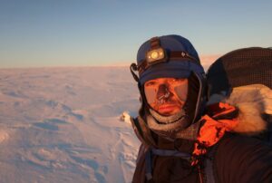
As usual, the last degree had it’s sandy, deep snow, uneven surface and sometimes uphill areas, which brought Henry “brief moments of surprising helplessness”. Unlike most skiers who end at the Pole, he still have food and fuel for 20 days for his route north to the bottom of the Shackleton Glacier.
The thin air of the altitude on the Polar Plateau, very often forced Henry to stop sledge-hauling and gulp for air [the proximity of the Pole adds another 1000m/3000ft to the altitude]. As he said, for high altitude climbers it might seem not high, but as everyone who has hauled a sled on the plateau or in the last degree knows, the lack of oxygen is clearly felt on Antarctica.
Early starts and long hours hauling is tiring as he described when he fell asleep on his sled during a break on Day 48. [North Pole 2010 expedition: Richard Weber and his son Tessum, deliberately took power naps during their 10-minute breaks]
Henry had to motivate himself during this last degree by telling himself to stop focusing on the end at the Ross Ice Shelf, but rather focus on the closer goal, the South Pole.
Good weather and little wind were pleasant but temperatures plummeted to -40. His face mask froze and restoring life to hands and fingers became a constant battle.
Henry says he is one day behind schedule and is taking a much-needed rest at the Pole today before heading North towards the Shackleton Glacier tomorrow.
Day 50 Jan 1 S89º 50.066 W44º 23.222
Time Travelled 12 Hours, Distance 13.5 nm
Accumulated Distance 561.5 nm, Altitude 9293 ft
Temperature -40°C Wind Speed 8 mph, Weather Cold
Day 51 Jan. 2 S90º 00.000
Time Travelled 9 Hours, Distance 10.0 nm
Accumulated Distance 571.5 nm Altitude 9340 ft
Wind-chill -42°C Wind Speed 18 mph, Weather Overcast
Antarctic solo traverse: Henry Worsley talks to Exweb/Pythom from Punta Arenas (2015)
Shackleton’s leadership skills, by Henry Worsley (2015)
Exclusive: South Pole anniversary final week interview with Henry Worsley (2012)
LUKE ROBERTSON (30) UK/Scotland, solo, Unassisted Unsupported 1130km, Hercules Inlet to Geographic South Pole, Started December 5, 2015.
Luke is experiencing better weather and firmer snow and makes good progress. He is well into 86 degrees and heading uphill towards the polar plateau. His tracker does not update his position anymore but his home team reported on Facebook that he has covered over 20 miles in 12 hours [Ed note, probably statute miles here and not nautical?]
ASSISTED UNSUPPORTED resupplies, no kites:
DOUGLAS TUMMINELLO USA, Assisted (emergency supply) Unsupported 1130km, Hercules Inlet – Geographic South Pole, Started December 6, 2015, at 7 pm, skiing for an hour.
Doug had a few of issues to manage so far; broken tent poles and teapot, an injured foot, bad snow and weather conditions. He managed them all, but he was slowed down and is now worried about his food supplies. He packed food for 50 days and
Day 24 (Dec. 29), Doug got to change underwear, socks and base layer. He also started wearing his polar down skirt over his wind pants to prevent cold weather injury on his upper legs (the so called, polar thigh).
On December 30 he reported: “Today also marks the halfway point of my provisions – I have 25 days food left. The problem is that I’m not close to the halfway point distances-wise! I’m still about 100 nm to the Thiel Mountains, which are at 85 South. At this point, it’s looking virtually impossible for me to reach the pole within the 50 days I planned. So what to do?? I’m thinking through the various alternatives now, but first I need to make it to the Thiels! After that, we’ll see.”
Latest available positions:
Dec. 31 -83.5128, -080.8371u2028
Jan 2: -83.9240, -080.8418
Jan 3: -84.0957 -080.8083
CARL ALVEY (UK, ANI guide), EMMA TAMSIN KELTY (UK), Assisted Unsupported 1130km, Hercules Inlet – Geographic South Pole, Started December 5, 2015.
With a slow first three degrees, polar thigh problems, and more, the team is behind schedule and Emma reported they have to do 11.5nm per day, every day until the end (no rest days) to get to the South Pole by the pick-up time. She described ups and down in her thoughts during the days. “On trail, not a lot is said so you are just lost in thoughts and there is not too much to look at in Antarctic (especially in a whiteout).”
Distances: 11.7nm, 13.1 nm in 8 hours, 14.47nm in 8 hours
DEVON MCDIARMID (CA, ANI guide), STEW EDGE (UK), MOSTAFA SALAMEH (Jordan), SHAHROM ABDULLAH (Malaysia), Assisted Unsupported 890km, Ronne-Filchner Ice Shelf (Messner) – South Pole, Started Dec. 9, 2015.
Conditions improved in 86 degrees but the team is now in 87 degrees, battling against the infamous sastrugi, up to 3 feet high at this stage. They are feeling the lower temperatures closer to the Pole.
Stew wrote the expedition is as much mental as it is physical, “Training mentally is very individual. For me, I have to break the challenge down into manageable sections. To think of a 500nm ski is just daunting, so I just look at the day I have to do. When I am following I have one hour until we change. When I am leading I break it down further and go from Sastrugi to Sastrugi which may be 100m or 500m away and my hour is soon done.”
He said he is getting into his green tea and drinking almost a litre with his dinner. “Good way to stay rehydrated, although the tea bag weighs more after use than before! I have started hanging them up to freeze dry them!”
Position: Stewart Edge Sun Jan 3rd, 9:54:15 pm (UTC+2)
Elev: 2301.36 m Lat: S 87°15’54.7920″ Lon: W 83°49’09.7500″
WEATHER MAPS:
Gateway port Cape Town, South Africa:
To ALCI /TAC base camp Novolazarevskaya / Novo
70° 46’37”S, 011° 49’26”E
Gateway port Punta Arenas, Chile, South America:
To ALE/ANI base camp, Union Glacier
79° 45’S, 083° 14’W elev 708m
Lat: -79.760591 Lon: -82.856698
Hercules Inlet is located at 80°S near Union Glacier, 1130 km from the Geographic South Pole.
The Ronne-Filchner Ice Shelf (Messner) start is 890 km in a straight line from the Pole.
Novolazarevskaya to South Pole of Inaccessibility (POI) is 1610 km in a straight line.
South Pole of Inaccessibility (POI)
2011-12 position: S82°06.696, E055°01.951 (Copeland/McNair-Landry)
On Dec. 14, 2014 Frédéric Dion reported the position the POI (at Lenin’s bust) as S82º 06.702′ E55º 2.087′ at an elevation of 3741 m.
Geographic South Pole (GSP): 90 degrees South
According to the Rules of Adventure at AdventureStats.com, to claim a “solo” achievement requires an unassisted status – therefore, no supplies carried by pilots or car drivers, or anything (food, fuel, etc) received from any person along the way. A solo person may be wind supported (kites/sails). Note that the Polar Rules were compiled by early Norwegian and British Polar explorers and are maintained today by the current community of veteran polar skiers.
1 nautical mile (nm) = 1.852 km
1 nm = 1.151 miles
1 knot = 1.852 km/h
1 degree of Latitude is 110 km / 60 nm / 70 miles
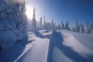
Sastrugi are hard snow bumps and can be as high as 10 feet
A nunatak is a top of a mountain visible above the snow surface.
Previous:
Antarctica: Christmas, and Teapot Air-Dropped
“}