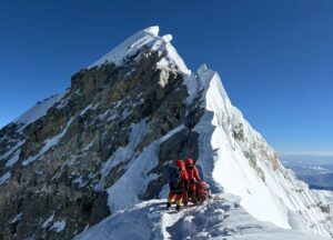
Crowded or lonely, under blue skies or wrapped in a storm, the highest point on Earth represents an unparalleled stage for glory and tragedy. Every year, more adventure seekers venture up its slopes, and many more dreamers follow their steps from their computer screens. Except this year, that is.

The Himalaya at sunset from the International Space Station. Photo: NASA
Since ExplorersWeb was founded, we have never had a quieter Everest season. The closest was in 2015, when a violent earthquake hit Nepal and put an abrupt end to the expedition season. But even then, we were able to report on the early stages.
Since a tiny virus closed the huge mountain, all we can do for the moment is study lines on maps and let pictures foster our dreams of future adventures. Here are some recommendations.
Everest – A Reconnaissance
The Royal Geographic Society has an online exhibition of photographs from the 1921 British Mount Everest Reconnaissance Expedition. They digitized a selection of old glass and celluloid negatives and made platinum prints from them. The exhibition highlights the exploratory nature of that early venture up Everest.

A pipe-smoking member of the 1921 British expedition, with Everest in the background. Photo: Royal Geographic Society collection
Although the highest point they reached was 7,000m, they spotted and mapped the main routes to the summit. Using the heavy photographic equipment of the time, they also captured the landscape and the people of Nepal and Tibet. Collectors can even purchase these limited edition platinum prints, although note that this is art to invest in, not posters to thumbtack to a wall. In other words, they aren’t cheap.

Shot at 6,000m by George Mallory himself, no doubt with his famous Kodak Vest Pocket camera, which has been missing since his fatal second Everest expedition in 1924. Photo: Royal Geographic Society collection
Everest 3D
Remember Jost Kobush‘s solo attempt on winter Everest some months ago? While the climber spent days up on the Lho La Pass and the West Ridge with no contact, we could follow his live location and planned route on a cool graphic, via an 3D Everest photo app.
National Geographic has now published a similar 3D representation of the North Side, thanks to climber-photographer Renan Ozturk. Last year, Ozturk joined an expedition to search for the remains of Mallory’s still-missing partner from 1924, Sandy Irvine.
Using specially modified drones from Camp 1 on the North Col, Ozturk captured 360-degree panoramas of Everest and its surrounding peaks. NG has also recently released the film Lost of Everest about their quest.

Everest North Side. Photo: National Geographic
A great Everest map
Finally, here is a 3D map of Everest, and a beautiful work it is. It was developed by ShadedRelief and High Mountain Asia elevation data at eight-metre resolution, which they obtained from the US National Snow and Ice Data Center, according to its creator. He added shading to the rocky areas in order to enhance the relief perception, while the snowy ridges and glaciers are based on a Landsat 8 image from June 2016.
The author also generously stated that the maps he released are public domain. “Consider these maps yours,” he writes on his website.