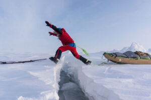
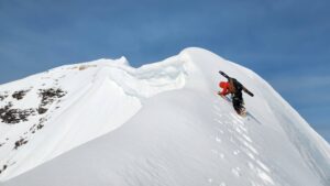
White-outs and 50m wide crevasses on ski routes. One team of climbers pinned on Vinson. Philips at Ulvetanna.
(Correne Coetzer, December 6-9 reports) The start out of Hercules Inlet challenged the three teams in total white-outs with no definition in the snow or sky. On the Messner route, good weather made sledge-hauling and navigation easier. Henry had his share of “miserable, mind-numbing monochromatic monotony” white-outs, again.
Michele is now man-hauling 155 kg, and passed 50 meter wide crevasses.
One team of climbers is tent-bounded at Vinson High Camp. Eric Philips is skiing and climbing near Ulvetanna.
Note: Definitions below according to AdventureStats.com:
assisted = resupplies
supported = kite/car/skidoo support u2028
HENRY WORSLEY UK solo
Unassisted Unsupported traverse 1100nm / 2037km
Berkner Island – Geographic South Pole – Shackleton Glacier (Ross Ice Shelf)
Started November 13, 2015.
Update: December 6-9, Day 24-27:
Another two days of total white-out, “grey as fog and thick as clotted cream,” had Henry “back inside the ping pong ball” spending him hunching over the GPS instead of “looking over the grey nothingness.” Trying to focus on something during the “miserable, mind-numbing monochromatic monotony,” made him fall over. Despite the visibility, progress was good because the snow surface was not so soft and deep anymore.
Before an expedition, skiers take off as much packaging from food and cut shorter or smaller where they can to reduce rubbish, which has to be carried out. Henry says he is reminded how much the rubbish bag fills up and how much it weighs in his sled. He gets up earlier and take one and half hour to get ready in the mornings. Travel time is 10 to 10.5 hours.
Henry entered his first sastrugi field on Day 27. Although the sastrugi were low, it required extra pull to get the sled across them.
Latest data: Dec 9 Day 27
Campsite Location S84º 59.654 W51º 53.444
Time Travelled Today 10 Hours 30 Minutes
Distance Today 13.1 Nautical Miles
Accumulated Distance 267.9 Nautical Miles
Altitude 4898 Ft
Temperature -23°C
Wind Speed 15 Mph
LUKE ROBERTSON UK/Scotland, solo
Unassisted Unsupported 1130km
Hercules Inlet to Geographic South Pole
Started December 5, 2015.
No definition between sky and land – just white, just white, Luke reported in short messages. “Powder snow makes tough skiing but happy with progress.” Latest report: the snow was still soft but he was hoping that the wind would hardening it nicely for today.
Latest position: Thu Dec 10th, 2015 5:13:15 pm (UTC+2) Elev: 847.81 m
Lat: -80.577475 Lon: -080.594115
DOUG TUMMINELLO USA solo
Unassisted Unsupported 1130km
Hercules Inlet – Geographic South Pole
Started December 6, 2015, at 7 pm, skiing for an hour.
Deep soft snow, a total white-out (he couldn’t tell up from down), a sled that got stuck at sastrugi, a headwind and gaining elevation, kept Doug busy. “Suffice it to say that I was never bored – just keeping a good fix on my location and direction was almost all-encompassing.”
Day 3 he reported making 3 miles in 8 hours. During the day he developed a bad blister because his right foot keeps rolling out.
DEVON MCDIARMID (CA, ANI guide), STEW EDGE (UK), MOSTAFA SALAMEH (Jordan), SHAHROM ABDULLAH (Malaysia)
Unassisted Unsupported 890km
Ronne-Filchner Ice Shelf (Messner) – G. South Pole
Started Dec. 9, 2015 at 13h50.
The last team to hit the ice. Stew reported the Twin Otter travelled at 140 Knots and a cruising altitude of 3400m from Union Glacier to the start point at the Ronne-Filchner Ice Shelf. They hauled 50 minute sessions with 10 minutes breaks in between and covered 4.25 nautical miles on Day 1. “We work in nautical miles down here as one degree is exactly 60 nautical miles which makes for simple sums.” No wind and sunny skies, reported Mostafa.
Camp1 at Lat: S 82°23’54.9888″ Lon: W 065°17’56.6340″ (Stew)
MICHELE PONTRANDOLFO (Italy) solo
Unassisted Kite-supported traverse: Coast at Novolazarevskaya – South Pole of Inaccessibility – Geographic South Pole – Hercules Inlet
Started November 19, 2015.
News from the Italian camp: Michele is still going uphill and covered 14 km yesterday, man-hauling his now 155 kg sleds, down from 180. He left a crevasse area where he could see crevasses as wide as 50 meters. Still no favorable kite winds.
Thu Dec 10th, 20151:02:00 pm
S 71º 46’23.66” E 010º 52’8.59”, elev 1934 m Elev: 1933.01m
ERIC PHILIPS (Australia, solo)
Unassisted Kite-Supported
Queen Maud Land “Discovery Trip”
Yesterday Eric “slogged 3km around the point west of Ulvetanna and entered the Sigynbreen. An hour in the wind sprang up from the NW and I launched my big blue (after an hour untangling a flustercuck) and kited the 20km east to the next mountain range. Just a few tiny crevasses on the far side and then a field of blue ice before finding a nice camp at the base of a pass. Today he wants to some climbs of local peaks. Every day is a “new adventure,” he says.
Camp 6, Elevation: 1508 m, Lat: 71° 50’ 27” S, Long: 008° 51’ 38” East
CARL ALVEY (UK, ANI guide), EMMA TAMSIN KELTY (UK), KHAI NGUYEN (CA/US)
Unassisted Unsupported 1130km
Hercules Inlet – Geographic South Pole
Started December 5, 2015.
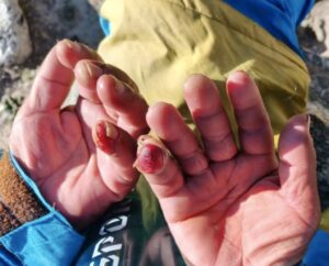
The team also reported the soft snow, headwinds and elevation. Emma said, as an ultra runner, doing 33-36 miles per day, doing 6 miles seems ridiculous. She is grateful that they don’t pull full loads. “It’s definitely tougher than anything that I have done to date. But….. I love it. Yes, it’s hard work, yes it is cold (frost bite is always near), yes you sweat (although you try not to)”
Khai reported, Carl had to use his compass while navigating and on December 9, when the clouds lifted, they were treated with a view on Patriot Hills.
MOUNT VINSON 4,892 meters (16,050 ft)
Madison Mountaineering summited on December 7, but Garrett, Mike, Sam, Iñaki and Todd are tent bounded at High Camp due to high winds. Gail force winds reached over 50 knots, but according to the forecast, the wind will reduce to 25 knots today. They reported that all other teams on this rotation are already off the mountain.
WEATHER MAPS:
https://earth.nullschool.net/
https://www.windyty.com/
Gateway port Cape Town, South Africa:
To ALCI /TAC base camp Novolazarevskaya / Novo
70° 46’37”S, 011° 49’26”E
Gateway port Punta Arenas, Chile, South America:
To ALE/ANI base camp, Union Glacier
79° 45’S, 083° 14’W elev 708m
Lat: -79.760591 Lon: -82.856698
Hercules Inlet is located at 80°S near Union Glacier, 1130 km from the Geographic South Pole.
The Ronne-Filchner Ice Shelf (Messner) start is 890 km in a straight line from the Pole.
Novolazarevskaya to South Pole of Inaccessibility (POI) is 1610 km in a straight line.
South Pole of Inaccessibility (POI)
2011-12 position: S82°06.696, E055°01.951 (Copeland/McNair-Landry)
On Dec. 14, 2014 Frédéric Dion reported the position the POI (at Lenin’s bust) as S82º 06.702′ E55º 2.087′ at an elevation of 3741 m.
Geographic South Pole (GSP): 90 degrees South
According to the Rules of Adventure at AdventureStats.com, to claim a “solo” achievement, requires an unassisted status – therefore no supplies carried by pilots or car drivers, or anything (food, fuel, etc) received from any person along the way. A solo person may be wind supported (kites/sails). Note that the Polar Rules were compiled by early Norwegian and British Polar explorers and are maintained today by the current community of veteran polar skiers.
1 nautical mile (nm) = 1.852 km
1 nm = 1.151 miles
1 knot = 1.852 km/h
1 degree of Latitude is 110 km / 60 nm / 70 miles
Sastrugi are hard snow bumps and can be as high as 10 feet
A nunatak is a top of a mountain visible above the snow surface.