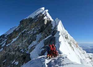
News about the Chinese expedition currently on Everest are scarce. The little information that does come out of Tibet is unrelated to the climb itself. Last week, it was about the live webcam and 5G antenna they installed at 5,800m on the north col route. Now it turns out that they will be aiming to measure the exact altitude of Everest.
China has already conducted two previous measurements of Everest. Back in 1975, they stated that the summit was 8,848.13m. In 2005, it shrank a little to 8,844.43m.
Apart from the 26-member climbing team, China has organized what it calls the 1st Geodetic Surveying Brigade. The 53 (!) would-be surveyors have been in BC since March, acclimatizing, learning surveying and climbing skills and preparing to measure Everest’s altitude from the summit sometime in May. The current operation collects data through the BeiDou-3 Navigation Satellite System, among other instruments.
Of the large group currently in Base Camp, the comparative numbers of porters, BC staff, drivers delivering supplies, technicians in charge of the 5G project, surveyors, guests and, let’s not forget, climbers are unclear.
What is clear, however, is that the wistful dream of a single team tackling a lonely Everest in this COVID year is just that, a dream. The cancellation of the season on the Nepal side and the elimination of foreign climbers from the Chinese side has given the one official group an opportunity to perform all kind of research undisturbed.