He just wanted to get some cool shots and ending up changing history. He also downgraded his own Manaslu climb in the process.
Photographer and blogger Jackson Groves became the star of this fall’s Himalayan season, thanks to the amazing drone footage he shared on social media. The images captured the summit area of Manaslu as never before. The side views and overviews deleted all previous doubts about where the highest point on the mountain is, what it looks like, and who really got there.
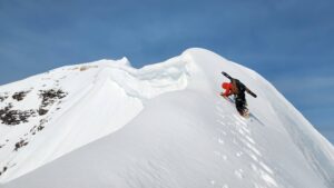
The summit of Manaslu will never look the same
Groves’ imagery earned unanimous applause from the international climbing community. At the same time, it brought about one of the most heated debates in years. The photos unmistakably showed that most climbers had stopped at the end of the ropes, at a point clearly below the summit. It also showed Imagine Nepal’s team traversing the west side of the ridge to reach the true summit.

Groves’ image shows climbers queuing for their selfie on Manaslu’s foresummit. Meanwhile, a member of the IG team, right, begins a traverse toward the main summit. Photo: Jackson Groves/Instagram
Audiences hurried to congratulate Imagine Nepal leader Mingma G but did not spare criticism of those other climbers who, falsely or wrongly, claimed a summit. The pictures made it obvious for the first time that they still had a way to go.
Some of these foresummiters didn’t realize the effect of Groves’ images until they looked at their social media feeds. Instead of praise, they found themselves peppered with questions. The backlash only grew more intense after the Himalayan Database confirmed that no one had summited Manaslu since Guy Cotter led his clients in spring 2012 and that all autumn summits since 1976 were actually foresummits.
The man who didn’t know he knew too much
Groves was one of those who had stopped short. Ironically, when he posted his images on social media, he hadn’t noticed the shape of the summit ridge, nor the tiny figures of Mingma G and his team.
“At the time of flying, I couldn’t actually see the group traversing to the true summit [because of] the shape of the ridge,” he told ExplorersWeb. “I didn’t even notice them while flying the drone.”
He explained that the extreme glare at that altitude and the bright sun prevented him from noticing such fine details on a little LCD screen. He was just trying to capture the line of people heading toward the regular summit (the foresummit).

Manaslu was Groves’ first 8,000m experience. Photo: Jackson Groves/Instagram
The images and the stir they caused caught Groves by surprise. Over the last five years, he had been traveling, hiking, backpacking, taking pictures, flying his drone, and feeding his personal blog, Journey Era. He had never been on an 8,000m peak before.
“I’m also new to the discussions surrounding the ‘true’ summit and ‘lower’ summit,” he explained. “I’m surprised that no photos or videos have emerged before this that show the side profile of the mountain!”
Rather than venture an opinion about an activity he is unfamiliar with, he prefers “to let an image do the talking [rather] than to make claims about summits, false summits, records, etc.”
Unintentionally, Groves has shown how drones can change the game in high-altitude mountaineering. The wider view that they provide can not only end controversies but explore new approaches to rescue and communication.
How to fly a drone at 8,000m
However, getting drones is to fly (and come back) above 8,000m is not easy. Groves explains:
“First, the air is thinner, so just as it is more difficult for a helicopter, there is less resistance against the propellers to create flight. [Second], the extreme cold at altitude can stop the batteries from functioning. It’s important to keep them warm inside your jacket or pockets until use. ”
The climber also has to carry the weighty drone up to such high altitudes. “In this instance on Manaslu, we had a Sherpa team who were capable of carrying heavier loads (including camera gear) at altitude.”
Groves used a DJI Mavic Air2s. His main problem was to get the batteries working in the cold.
“I had three batteries with me and the first two wouldn’t launch because of cold battery warnings,” he recalled. “But the third got the propellers moving. I then let it warm up on the ground for a few minutes before trying to launch.”

The drone soared away from Manaslu’s summit, showing clearly the profile of the final ridge and the spiky main summit. Photo: Jackson Groves/Instagram
On his first attempt, the drone hovered just inches from the ground, then dropped. But the second time, he was able to fly it around the summit for 20 minutes. Once it was warm and flying, the drone had no further problems with cold batteries.
Easy to lose drones
In the past, drones used on 8,000m peaks sometimes flew but then suddenly dropped were lost forever. That was Alex Txikon’s experience on Nanga Parbat three winters ago, when he searched for Tom Ballard and Daniele Nardi. One of his drones approached the infamous Mummery Spur where the pair had gone missing, but then it suddenly lost power and fell in a crevasse.
Winter Nanga Parbat is colder than autumn Manaslu, and Groves experienced no such trouble. “The drone landed successfully in the same place where it took off, ” he said. “I launched it from just below the regular summit ridge, at about 8,100m. It flew around the regular summit [foresummit] and then also had good views of the first rope-fixers to the ‘true’ summit.”

Drones could become essential to prove successful summits on “tricky” 8,000’ers such as Manaslu, Dhaulagiri, and Broad Peak. Photo: Jackson Groves/Instagram
Drones have other uses on high-altitude expeditions, besides giving evidence of success, says Groves.
“Drones could be used in search-and-rescue operations too dangerous for helicopters,” he says. “DJI actually has drones that can send signals and even have speakers, so that the pilot can give people on the ground certain instructions or messages. There are also thermal drones for search and rescue. Even drones like mine that cost just slightly more than $1,000 can search for people, explore routes, or analyze mountain topography, as in this instance.”
Below, a video of Groves’ life and work over the past five years: