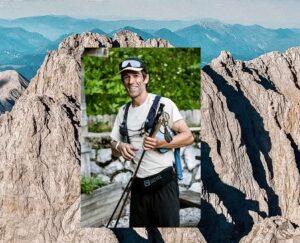
There are many adjectives to describe Kangchenjunga (8,586m), the third highest peak on Earth. The first and simplest is “huge”. But for Italian 14×8,000m summiters Nives Meroi and Romano Benet, it represents so much more than mere size. It’s the mise-en-scène for a drama of near-death, love, and a lifetime challenge finished together.
Meroi and Benet needed three tries to summit. All their attempts were without supplementary oxygen. On their first, in 2008, Romano felt suddenly ill while in Camp 4. Nives helped (sometimes dragged) him down to Base Camp. Here, they had to walk out.
At the time, Nives was in a race to become the first woman to summit the 14×8,000’ers. But while rivals Edurne Pasaban, Gerlinde Kaltenbrunner, and Mi-sun Go hurried to their next expedition, her husband’s illness took Nives down a different path.
The following two years consisted of long stays in hospitals, confused doctors, two bone marrow transplants and a hard, slow recovery. The couple remained at home in the mountain town of Tarvisio, in Italy’s northeast corner between Austria and Slovenia.

Romano Benet and Nives Meroi. Photo: @Nives Meroi
From the first stages of Benet’s illness, Meroi declared herself “happily” out of the race. “Romano comes first,” she told ExplorersWeb at the time. In addition, she was not comfortable with the increasing use of Sherpa support and O2 involved in that record quest.
Instead, she stayed with her husband throughout his recovery. Finally, she returned with him to Kangchenjunga in 2012, along with Peter Hamor and Horia Colibasanu. On that occasion, they learned the importance of careful navigation on that massive peak. On summit day, the two Italians and Colibasanu chose the wrong couloir. Peter Hamor reached the main summit, while the other three found themselves on the lower central point.
When they returned to Kangchenjunga in 2014, things were starting to change: Commercial expeditions were taking over and changing the experience forever. However, the Italian couple managed to launch their final summit push one day ahead of the others. They enjoyed and suffered the mountain as it had always been, with no ropes, alone.
That is significant because the higher you climb on Kangchenjunga, the harder it becomes. Below, they describe the entire route for ExplorersWeb.
The approach trek
The trek to Kangchenjunga is one of the most beautiful in Nepal. “But it is also the most strenuous,” Romano explained, “because instead of going up a single valley, it traverses one valley after another. A new road has lessened the trek by two days, but it still takes five to six days to reach Base Camp. The two last days on glacial terrain are especially difficult for the porters.”

An intermediate camp on the Yalung Glacier, en route to Base Camp. Photo: Nives Meroi/Romano Benet
Lodges are scarce and not as well supplied as in other areas. “Groups now skip the walk and take a helicopter to Base Camp instead,” Benet said. “They save time but miss a really beautiful stage of the expedition.”
Climbers catch that airlift to Base Camp from a helipad at Seram. “Nepal’s skies are looking more and more like highways,” said Nives.
Phillipe Gatta offers further information on the trek here.
Base Camp (5,400m) to Camp 1 (6,000-6,200m)
Base Camp is comfortable, typically very sunny, and lies on dry, grassy ground. Its only problem is water — there is none nearby — so all water comes from a place that is a 30-minute trek from BC.
The snowy surface begins shortly after leaving Base Camp.

From Base Camp to the col at Camp 1. Photo: N. Meroi/R. Benet
The route goes up the slopes on the west in order to avoid the Kangchenjunga Glacier’s icefall. “There are 700 vertical metres of medium-difficult terrain, mainly steep (up to 50º) snow ramps,” Romano said. “Sherpas with bigger teams always fix that section.”

Climbers at the saddle, before they descend to the glacial plateau. Photo: N. Meroi/R. Benet
After mounting the lateral slopes, climbers reach a distinctive saddle. From that point, there are some 200 vertical meters to go, back down to the Kangchenjunga Glacier.
Most teams build their Camp 1 right on the saddle, while others push further and descend to the glacier. This is what Meroi and Benet did in 2014 on a long, first day above BC.

Looking from the col down on the glacial plateau. Photo: N. Meroi/R.Benet
Camp 1 (6,000-6,200m) to Camp 2 (approx. 6,400m)
The next section crosses an immense plateau, on flatter yet crevassed terrain. On that 1.5km-long shelf, there is no one spot for Camp 2. Rather, each expedition estimates distances and strength, and pitches its tents somewhere on the plateau, fairly close to the face that rises at the end of it.

Looking back from the Italians’ tent at 6,200m on the plateau. Photo: N. Meroi/R.Benet
Camp 2 to Camp 3 (6,800-7,200m)
The same goes for Camp 3: It may lie at the end of the shelf or on the first slopes of the face. The lower part of the face is steep but not too technical. The hardest parts are where seracs cannot be avoided and must be climbed.
“These seracs are all along the route,” Benet said. “Some are easy to climb, some are more difficult.”
Commercial teams fix the steeper sections. “[How difficult they are] depends on the snow and ice conditions, which vary from fresh, deep snow to very hard ice,” said Meroi.
Benet added: “The good thing is that these sections are short: 30 to 50m each. They form a sort of gigantic stair from 6,200 to 7,200m.”

Camp 2 and the route ahead, showing two possible locations for Camp 3. Photo: N.Meroi /R. Benet
You can pitch Camp 3 at the upper part of the serac barrier or higher up. Above the seracs, climbers reach another plateau. The first expeditions called this the “Great Shelf”.
“We pitched our Camp 3 well up the Great Shelf, but other expeditions had set theirs lower down, at about 6,800m,” Meroi recalled. “Kangchenjunga is so long that the strategy about camps varies from team to team. There are endless possibilities.”
At the Great Shelf, one must take care to follow the most logical route to the summit. This is no problem in good weather, but difficult in a whiteout, both on the way up and on the way down.
Camp 3 to Camp 4 (7,500-7,600m)
“That is, of course, unless you fix the entire route,” Benet said. “That is what we found in 2014. When we returned from the summit, there were ropes all the way down from Camp 4, probably 5,000 to 6,000m of rope in all.”

Camp 3 on Kangchenjunga. Photo: N.Meroi /R. Benet
The route from Camp 3 to Camp 4 is the easiest of the whole climb, according to Romano Benet. As long as one does not get lost on the plateau in bad weather, it’s just walking until Camp 4, which is usually around 7,400m. Although Meroi and Benet pitched their higher camp some 200m higher, “it was inside a crevasse,” said Meroi.
From Camp 4, the situation changes radically until the summit.
Summit day (7,600m to 8,586m)

The route from Camp 3 to the summit. Photo: N.Meroi/R.Benet
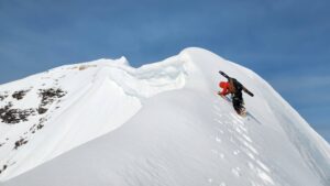
The imposing last section of Kangchenjunga is mainly on rock, with some ice and mixed sections. If there are no ropes, it is essential to memorize the most sensible way up the face to the summit.
“Bear in mind that you will set off at night,” said Benet. “There are so many couloirs that mistakes are easy to make.”
You start up a 700m-long couloir of 45-50º hard snow leading to the rocky face. The face, they explain, is mainly vertical, technical rock with some mixed sections. There are several Grade III passages — not that easy at 8,000m wearing mittens and expedition boots.
Again, the face is so big that it allows many variations, but the difficulty is virtually the same everywhere. There is no chance to relax until the summit.
“Jorge Egocheaga had told us that there was a short rappel somewhere near the summit, and I was fearing that moment,” Nives Meroi recalled. “But we never came to a rappel point. Instead, we eventually just reached the summit. Obviously, the Spaniards had taken a slightly different route. That is why it is so important to study and pick the most logical line.”
Benet pointed out that commercial teams take a longer way where they can fix the ropes better. “We are more used to alpinism and looked for the most direct line to the top,” he said.

The summit of Kangchenjunga. Photo: N.Meroi/R.Benet
Both climbers agree that the summit itself is unmistakable. “It’s a 10m-tall tower ending in a flat granite platform, quite comfortable for taking pictures.”
Some climbers diplomatically stay away from this highest point, out of respect for the people of Sikkim, for whom the mountain is sacred. “I stopped just a couple of steps before the highest point,” said Meroi.
Getting down
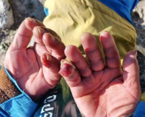
Meroi emphasizes how important it is to keep strength in reserve for the descent. “It’s demanding, technical, and exposed, especially if there are no fixed ropes,” she said.
On their climb, the couple had only a 20m rope that they used to rappel down the vertical sections. Some they just downclimbed. But it’s nearly 1,000 vertical metres from the summit down to Camp 4, and it requires a climber’s full attention and skills. In low visibility, the chance of getting lost increases dramatically.
Without oxygen or ropes, C4 was about the limit for Meroi and Benet. “We left at midnight and we came back from the summit to our C4 tent at 6 pm,” Meroi said. “It’s not uncommon for climbers to reach Camp 4 at night,” Benet added.

Back down the valley. Photo: N.Meroi/R.Benet
Despite its challenging 1,000m between Camp 4 and the summit, Kangchenjunga is an unforgettable experience. “It’s so huge and so beautiful,” Romano said. “I also like its technical difficulty. It is an alpinist’s peak, where you actually have to climb, not just walk up.”