The northern Tien Shan ranks among those remote places where lots of unclimbed peaks remain for adventurous climbers. A Russian team bypassed the better-known mountains of the Ala Archa Gorge, a climber’s favorite, for some first ascents in the upper gorge. Peaks are a “mere” 3,400m to 4,000m there. Former Soviet climbers ignored them because of their modest stature. Since then, the place has remained largely untouched.
In September 2022, the climbers opened two routes on a previously unclimbed and unnamed mountain, only mentioned on maps as the “Black Wall”.

Upper sections of Ala Archa gorge, in northern Tien Shan.
“The first time I went to Upper Ala Archa was not for mountaineering,” said expedition leader Maxim Foygel. “We had planned to spend about a week ski touring. But the idea of potential new ascents settled in my mind almost immediately. This Black Wall seemed like a magnet, especially compared to its less expressive neighbors. Each step up the valley attracted me more and more.”

Nomad’s Peak in 2021.
Ignored and forgotten
“The relatively low altitude and small size of the wall were not interesting for climbers in Soviet times, as it did not promise any prizes in the national mountaineering championships,” Foygel explained. “After the collapse of the Soviet Union, the area was simply forgotten, and any scraps of information have not reached modern climbers. So for us, it became even more exciting to organize a small expedition there.”

Kochevnikov or Nomad’s Peak in autumn 2022.
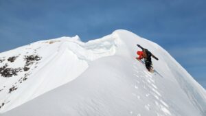
The team climbed a route up the NW Face that they had previously studied in photos at home. “Although it is not a big wall, to climb about 400m of vertical on a fairly steep Northwest Face was quite a challenge,” said Foygel.

Susko on pitch four on Nomad’s Peak.
Foygel climbed with Denis Sushko and regular partner Alexander Lange. Here is his account of the climb:
We…wanted to do as little aid-climbing as possible. However, we were prepared for surprises. Our wall, although not huge, was very steep and completely dry. So, we had to bring water as well as food with us, as we planned to stay on the wall for two or three days.
It soon became clear that we wouldn’t be able to climb all the pitches free. The terrain is very steep, and the cracks are mostly very thin. [We had to] either aid climb or risk long falls with bad consequences. The crux pitch was done using skyhooks.
Susko on Pitch 7. Photo: Maxim Foygel
‘Wall of Shadows’
At about the mid-point of the wall, under the overhang, we were lucky to find a small ledge. However, we had to work to organize a decent bivouac spot.
Bivy on the wall. Photo: Maxim Foygel
As a result, we climbed about 400m of vertical, of which about 300m were on a steep wall with free climbing up to 6b and aid climbing up to A3. We named the route “Wall of Shadows” because the sun only warmed our line for one hour before sunset.


“Wall of Shadows” on Nomad Peak.
After returning to Base Camp, the team felt good but had an appetite for more. So on the following day, after studying various options, they decided to climb the same peak via its West Ridge.
At 8 am we started the climb. The line runs logically along the ridge, only occasionally skirting some steep sections to the right and left of it. The first steep section of three pitches is quite enjoyable climbing up to 5c. Then follows another section of easy terrain, and afterwards — the most unpleasant part — came two short sections of broken and steep rock. Finally there’s just some easy climbing to the top.
One of the crux pitches on the West Ridge.
The route, which we named “A20”, comprises about 325m of vertical, including 5 pitches from 4c to 5c. There is a section of loose rock under the top that could be eventually cleaned. Then it would become a very nice D+ route.
The descent was fairly easy. Except for a 40m rappel, the rest is walking, although carefully at some points.

The GPS device and the altimeter that they carried showed variable readings, so they only gave an approximate altitude of 3,400m.
Since this peak had probably never been climbed before, the climbers hoped to name the mountain Korchevnikov (Nomad’s) Peak.

The routes opened on Nomad’s Peak.
Below, a video on the climb (English subtitles available).