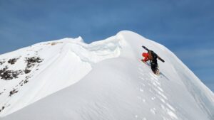
The Second Seven Summits involves climbing the second-highest peak on each continent. Today, we take a look at the second highest peak in Australia, Mount Townsend (2,209 m).
The Bass list versus the Messner list
Mount Townsend is almost four kilometres north of Mount Kosciuszko, which is one of the Seven Summits, at least according to American businessman/mountaineer Dick Bass.
The Bass list differs from Reinhold Messner’s list, which credits Puncak Mandala (4,760m) in Papua, Indonesia as the region’s second-highest summit. Messner’s list is based on the continental plate argument, which puts Papua within Australasia.
We’ll tackle the list debate in a future article, but for now, we’ll stick to the Bass list. By this metric, Mount Kosciuszko is one of the seven summits and Mount Townsend is one of the second seven summits.

The Snowy Mountains, also known as The Snowies. Photo: Ross Dunstan
Easy but interesting
Generally, the second seven summits are more difficult to climb than the seven summits. However, this difference in difficulty is not striking in the case of the two highest mountains in Australia. Both Mount Kosciuszko (2,228m) and Mount Townsend (2,209m) are easy to climb, although Townsend is more craggy and harder to access than Kosciuszko. However, the height difference is minor.
The history of Mount Townsend hides curiosities, and cannot be separated from the highest peak, Kosciuszko, both within the Kosciuszko Natural Park.

Location of Mount Townsend and the Snowy Mountains in Australia. Photo: Wikipedia
The Snowy Mountains
The Snowy Mountains range is in southern New South Wales and is part of the Great Dividing Range. It contains not only Mounts Kosciuszko and Townsend but a handful of other 2,000m peaks.

Great Dividing Range, Australia. Photo: Wikipedia
The Ngarigo people of that region had surely explored the mountains much earlier than the first Europeans. In 1770, James Cook may have been the first European to spot the mountains of the Great Dividing Range. But 160km from Mount Kosciuszko, he would have only seen the foothills of East Gippsland.

More peaks in the Snowy Mountain Range.
In 1824, Hamilton Hume and William Hovell set off into eastern Australia to find new grazing land and to explore where the western rivers of New South Wales flowed.
“We were suddenly surprised by a sight, to the highest degree magnificent: mountains of an immense height, and some part of them covered with snow,” they recalled. Still, Mount Kosciuszko remained hidden to them, tucked behind the Townsend-Abbott mountain groups.
In 1830, Austrian naturalist and writer Johann Lhotsky arrived in Australia. In May 1832, he climbed Mount William IV and claimed to have climbed to the highest point ever reached by any traveler in the Australian continent. This mountain was actually Mount Terrible, 1,855m high, and 13km southeast of Mount Kosciuszko. So he did not climb the highest peak, but he was possibly the first to see its summit.
A local stockman called Stewart Ryrie came the closest to the Kosciuszko summit, staying just a 30-minute horse ride from it. Then on February 15, 1840, he became the first to ascend the Kosciuszko massif.

The summit of Mount Townsend, with Kosciuszko in the distance. Photo: Damien Gildea
A Polish explorer
In the late 19th century, Polish scientist Pawel Edmund Strzelecki contributed greatly to the exploration of Australia, especially in the Snowy Mountains and Tasmania.

Pawel Edmund Strzelecki. Photo: Wikipedia
As part of an extensive world tour, he arrived in Sydney in April 1839. He was also interested in the mineralogy of the continent and found gold and silver near Hartley and Wellington in New South Wales. However, Governor Sir George Gipps decided not to publicize the discovery at the time, fearing the effect would disturb the convicts who made up a large part of the population.
In the spring of 1840, Strzelecki organized an expedition to the Australian mountains, together with James Macarthur, a grazier of Yass Plains, and 19-year-old James Riley, a stockman who worked for Macarthur. An aboriginal guide, Charley Tara, accompanied them. The young Tara came from inland Gundungurra, near Goulburn (New South Wales).
The expedition aimed to find land suitable for cattle grazing near the coast. It took the explorers from the Goulburn Plains south toward the Australian Alps. The party set out on February 5, 1840, from Ellerslie Station near Adelong. They arrived at Welaregang on March 7, 1840, and picked up a second aboriginal guide, Jackey. Jackey had previously climbed mountains in search of Bogong moths, which were part of the aboriginal diet.

Hannel’s Spur, also in the Snowy Mountains, begins at 450m and ends at 2,228m. At almost 1,400 of climbing, it is the greatest elevation rise in Australia. Photo: Trackslesstravelled
The first ascent
After a month, they were already in the range. After climbing Hannel’s Spur on March 11, 1840, “Strzelecki and I then proceed toward the extreme summit which we reached after a very laborious climb. The air was bitterly cold. We found the actual summit divided into six or more points,” Macarthur wrote.
They were really on top of today’s Mount Townsend. “The Count [Strzelecki] by the aid of his instruments quickly detected one of them as being in fact considerably higher than where we stood. A deep ravine separating us from this did not deter my adventurous friend,” continued Macarthur.

Painting of Tadeusz Kosciuszko. Photo: Commonplacefacts
Macarthur decided to descend, while on the afternoon of March 12, 1840, Strzelecki climbed the highest peak alone. He named the peak Kosciuszko, after the Polish-Lithuanian general Andrzej Tadeusz Bonawentura Kosciuszko.

Mount Townsend. Photo: Alchetron
Eating koalas
After the climb, the group continued south to the Omeo Plains, then west toward Corner Inlet. By then, the explorers and their horses were exhausted and hungry. They only had food for four days. Strzelecki changed their route toward the Western Port, but the distance he calculated was wrong. Instead of just 32km, it was really over 100km away.
The explorers had no other option. They abandoned their horses and most of their equipment. They hunted and ate koalas. “In the country through which we passed there was but one animal,” Riley said later. “It is the size of a small dog and lives in trees. It is called the monkey or native bear. These we procured sometimes by shooting, sometimes by the natives climbing the trees after them. We ate them raw when we could not make a fire.”
Finally, 22 days later, they arrived at a convict settlement in Western Port, where they were given food. From there, they continued to Melbourne.
Strzelecki made several maps of the route and gave them to Riley. He dedicated one of the maps to his companion and wrote on it: “To Riley, from your fellow monkey-eater.”

Granite boulders near the summit of Mount Townsend. Photo: Damien Gildea
Utter confusion
After this trip, the highest peak in Australia was mapped. However, a later cartographical error accidentally moved Mount Kosciuszko to the position of present-day Mount Townsend on Victorian maps. Though the New South Wales maps did not make this mistake, the erroneous Victorian edition created a great deal of confusion.
In 1885, Austrian explorer Robert Lendlmayr von Ledenfeld, guided by the erroneous map, ascended Mount Townsend accompanied by a local shepherd, believing he was on the top of Mount Kosciuszko. The same thing happened to him as to Strzelecki: At the top, he realized that a nearby peak was higher. Noticing the higher peak, he named that Mount Townsend, after geodesist Thomas Townsend. This created even more confusion. So now Kosciuszko was Townsend, and Townsend was Kosciuszko.

Albina Lake, Snowy Mountains of Australia. Photo: Wikipedia
Finally, in 1940 the confusion was sorted out. Cartographer and historian B. T. Dowd reaffirmed that the highest mountain, which Strzelecki had named Mount Kosciuszko, was indeed the highest peak in Australia.