Eric Philips halfway to Ulvetanna. (5 images)
(Correne Coetzer) “Difficulties can be overcome by patience and not a feeling of confrontation, but rather moving with, not against,” traverse skier, Henry Worsley shared yesterday from 84ºS. He will remember the day as “how to be more at ease with the remarkable place”. For the first time, he noticed gradual firmness in the snow. As a result of this he “moved much more in tune with the moment rather than seeing it as a battle. And that is how you have to come to terms with Antarctica, be patient, don’t fight her, move with her, and respect her.”
Robert Swan, who skied to the SouthPole 30 years ago, talks on Henry’s site about safety while skiing on Antarctica.
Solo skier, Luke Robertson, and Carl Alvey and his team, Emma Kelty and Khai Nguyen, started at Hercules Inlet. Devon McDiarmid and his team, Stew Edge, Mostafa Salameh and Shahrom Abdullah were still at Union Glacier yesterday.
Michele Pontrandolfo’s latest position and Vinson summits reported.
Note: Definitions below according to AdventureStats.com:
assisted = resupplies, and supported = kite/car/skidoo support u2028
HENRY WORSLEY UK solo
Unassisted Unsupported traverse 1100nm / 2037km
Berkner Island – Geographic South Pole – Shackleton Glacier (Ross Ice Shelf)
Started November 13, 2015.
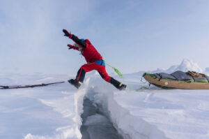
December 2-5, Day 20-23 wrap-up: u2028In white-out conditions, Worsley was traveling down-hill, no idea of the degree of the slope, the sled overtook him and pulled him over. Almost twice his weight, it dragged him for 20 yards, flipped over twice and came to rest upside down. Fortunately all the fuel canisters and Henry were fine. His big regret with the bad weather is that he could not see all of the mountains there.
Henry explained how he charge his electronics: he has a [HET P50] battery that he charges with a solar panel and then uses the battery to charge all his devices.
The sun came through and weather turned to “glorious”, which made navigation easier. The soft surface made for low milage, which made his heart sink into the snow”. On Day 21 Worsley gave a positive medical report.
Fellow Brit, Robert Swan talked about safety on Henry’s website and pointed out his “faultless” planning and preparation, and the danger of crevasses.
Stats Dec. 5 Day 23
Campsite Location S84º 03.846 W51º 42.387 with distant nunataks and the fading view of the Pensacola Range
Time Travelled 9 Hours 30 Minutes
Distance 10.6 Nautical Miles
Accumulated Distance 211.6 Nautical Miles
Altitude 4114 Ft
Temperature -10°C
Wind Speed 2 Mph
Weather Cloudy
LUKE ROBERTSON UK, Scotland solo
Unassisted Unsupported 1130km
Hercules Inlet to Geographic South Pole
Started December 5, 2015.
Relatively slow going uphill on the first day, Luke reported. He is carrying all he needs for the whole expedition in his 130kg sled. The surface is covered with thick powder due to the huge snowfall the past week, “Great for back-country skiing – not so for man-hauling,” he added.
“Starting off at a latitude of 79 degrees South, the route first heads West, rising and skirting around the Wilson nunataks before eventually heading south, leaving behind the Ellsworth mountains. I won’t see those again until January. Excluding the direction taken over the first few days and at times when avoiding crevasses, I shouldn’t be veering too far from a longitudinal corridor of 80-81 degrees the whole way to the Pole. Losing 1.35kg per day from the pulk in the form of food and fuel, the pace should begin to pick up as the load becomes lighter and the terrain becomes more manageable. The weather too will of course play its leading role in deciding state of progress – as it has already done over the last two weeks.”
Position: Sun Dec 6th, 2015 2:37:00 pm
Elevation: 372.00 m Lat: -79.997516 Lon: -080.045615
Sun Dec 6th, 2015 6:37:00 pm
Elevation: 482.92 m Lat: -80.019855 Lon: -080.199551
DOUG TUMMINELLO USA solo
Unassisted Unsupported 1130km
Hercules Inlet – Geographic South Pole
After waiting some time in Punta Arenas, Doug has arrived at Union Glacier yesterday, where he spent the afternoon setting up camp, sorting gear, and checking systems. If all goes well, I might be able to fly to Hercules Inlet today to get underway, he reported.
DEVON MCDIARMID (CA, ANI guide), STEW EDGE (UK), MOSTAFA SALAMEH (Jordan), SHAHROM ABDULLAH (Malaysia)
Unassisted Unsupported 890km
Ronne-Filchner Ice Shelf (Messner) – G. South Pole
Bad weather at their start point at the Ronne-Filchner Ice Shelf, prevented the team from flying from Union Glacier yesterday.
MICHELE PONTRANDOLFO (Italy) traverse solo
Unassisted Kite-supported
Traverse: Coast at Novolazarevskaya – South Pole of Inaccessibility – Geographic South Pole – Hercules Inlet
Judging at his positions, still no wind for kiting, only slow going while sledge-hauling heavy sleds.
Fri Dec 4th, 2015 8:27:00 pm
S 71º 26’41.62” E 010º 50’34.66”, elev 1441 m,
Sat Dec 5th, 2015 2:28:30 pm
S 71º 28’32.16” E 010º 48’34.28”, elev 1445 m,
Sun Dec 6th, 2015 4:54:15 pm
S 71º 37’23.52” E 010º 39’18.15”, elev 1648 m,
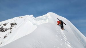
ERIC PHILIPS (Australia, solo)
Unassisted Kite-supported Queen Maud Land “Discovery Trip”
Eric started on Dec 4 on a windless day and sledge-hauled 10km. Crevasses will always be a hazard, he reported, “but years of skiing over glaciated terrain have taught me to read the ice and make the correct decisions.”
Day 2 he got wind and covered 73km, gained 800m to 1342m and is halfway to the magestic mountain, Ulvetanna. He changed kites 6 or 7 times to accommodate varying wind strength, “at one stage leaving the 14sq/m up too long in strengthening wind and having a mini epic trying to pack it away.”
Camp 1 Elevation: 731 m Lat: S70° 52’ 28”, Lon: E011° 26’ 57”
Camp 2 Elevation: 1343 m Lat: S71° 20’ 56” Lon: E010° 3’ 36”
CARL ALVEY (UK, ANI guide), EMMA TAMSIN KELTY (UK), KHAI NGUYEN (CA/US)
Unassisted Unsupported 1130km
Hercules Inlet – Geographic South Pole
Started December 5, 2015.
The team skied about 2 hours and cover about 2.1 nautical miles (x1.852 = 3.89km), reported Khai. Although the snow was heavy, as Luke reported, they had a “fantastic” day, both Emma and Khai reported. The difference with their expedition and Luke’s, is that this team has only a part of their food and fuel in their sleds bacause they will get resupplies along the way.
DEVON MCDIARMID (CA, ANI guide), STEW EDGE (UK)
Assisted Kite-supported Traverse
Ronne-Filchner Ice Shelf (Messner) – G. South Pole – Hercules Inlet
Traverse: resupply at SP, kite-ski from Pole, 2020km
See above for Leg 1, Coast to Pole.
MOUNT VINSON
ANI reported nine guests, accompanied by ANI guides Scott Woolums, Tre-C Dumais, and Zac Poulton on the summit of Vinson.
Madison Mountaineering reported to have made a carry up the fixed lines from Low Camp to High Camp.
Vinson data courtesy of Adventure Network International (ANI):
Vinson Base Camp (VBC) is located on the Branscomb Glacier 95 miles (151km) from Adventure Network/ANI’s main camp, Union Glacier. The geographic location is 78º32’S, 086º00’W at an elevation of 6900ft (2100m) above sea level. The flight from Union Glacier to VBC with a Twin Otter takes about 30 minutes across the Sentinel Range in the Ellsworth Mountains.
Low Camp is located at 2750m / 9000ft. The ascent from VBC to LC is 650m / 2150ft, takes 4-6 hours over a distance of 9 km / 5.5 miles.
High Camp is located at 3700m / 12,400ft: A 1020m / 3350ft ascent from Low Camp, 6-8 hours, 3km / 1.8 miles, 1200m fixed ropes, up to 45° slopes.
Summit at 4892m / 16,160ft (feels like 5500m): 1120m / 3670ft ascent from High Camp, 14km / 8.75 miles return.
WEATHER MAPS:
https://earth.nullschool.net/
https://www.windyty.com/
Gateway port Cape Town, South Africa:
To ALCI /TAC base camp Novolazarevskaya / Novo
70° 46’37”S, 011° 49’26”E
Gateway port Punta Arenas, Chile, South America:
To ALE/ANI base camp, Union Glacier
79° 45’S, 083° 14’W elev 708m
Lat: -79.760591 Lon: -82.856698
Hercules Inlet is located at 80°S near Union Glacier, 1130 km from the Geographic South Pole.
The Ronne-Filchner Ice Shelf (Messner) start is 890 km in a straight line from the Pole.
Novolazarevskaya to South Pole of Inaccessibility (POI) is 1610 km in a straight line.
South Pole of Inaccessibility (POI)
2011-12 position: S82°06.696, E055°01.951 (Copeland/McNair-Landry)
On Dec. 14, 2014 Frédéric Dion reported the position the POI (at Lenin’s bust) as S82º 06.702′ E55º 2.087′ at an elevation of 3741 m.
Geographic South Pole (GSP): 90 degrees South
According to the Rules of Adventure at AdventureStats.com, to claim a “solo” achievement, requires an unassisted status – therefore no supplies carried by pilots or car drivers, or anything (food, fuel, etc) received from any person along the way. A solo person may be wind supported (kites/sails). Note that the Polar Rules were compiled by early Norwegian and British Polar explorers and are maintained today by the current community of veteran polar skiers.
1 nautical mile (nm) = 1.852 km
1 nm = 1.151 miles
1 knot = 1.852 km/h
1 degree of Latitude is 110 km / 60 nm / 70 miles
Sastrugi are hard snow bumps and can be as high as 10 feet
A nunatak is a top of a mountain visible above the snow surface.
Previous in the link below: Skiers and Climbers in Storm in West Antarctica