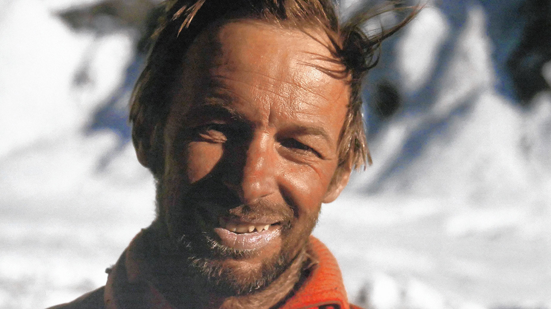
Some mountaineers are real explorers. Austrian Hanns Schell fits that description. He was a master of 7,000m first ascents and made time to ascend four 8,000’ers for good measure. His route on the Rupal Face of Nanga Parbat (now named the Schell Route) is an alpine masterpiece. Let’s examine Schell’s five first ascents on 7,000m peaks.

Hanns Schell on the Rupal Face of Nanga Parbat. Photo: Festivalalpinismu
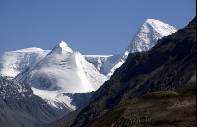
Momhil Sar
In 1964, Schell led an Austrian team that included Rudolf Pischinger, Horst Schindlbacher, Leo Schlommer, and Rolf Widerhofer. They targeted 7,343m Momhil Sar, located in the Hispar Muztagh of the Karakoram.
“We were a group of friends who had been climbing together in the Alps for years,” Pischinger wrote in the Alpine Journal.
Four years earlier, Wilfrid Noyce of Britain and Jack Sadler of the U.S. had made the first ascent of nearby 7,577m Trivor. Before Noyce tragically died on Mount Garmo in the Pamirs in 1962, he gave Schell’s team some useful information on the area’s mountains. This included a photo of unclimbed Momhil Sar.
The early climb
The Austrian party reached Momhil Sar base camp on May 15, 1964. They put their tents in the exact spot where the English team had pitched theirs four years earlier, at around 4,600m. Noyce wrote of a meadow with flowers, but the Austrians had to pitch their tents in almost two meters of snow.
The team wanted to ascend by the east ridge. Observing the weather, they noted that at midday, mist often came down the mountain, and snowfall usually followed. This meant that they could only climb for half of each day.
The team started moving up. Until Camp 2 and even a little above, they used skis. But by June 10, they faced a steep snow slope that led to a saddle that Noyce and Sadler had used as Camp 3 four years earlier.
From here, the route toward Trivor’s summit followed a long ridge, while the route to the summit of Momhil required climbing an east ridge that abruptly rises from the saddle.

The southeast face of Momhil Sar. Photo: Horts Schindlbacher via Alpine Journal UK
Loose cornices and powder snow
Trail breaking was not easy. Above Camp 2, at around 6,200m, a scary, dangerously unstable bridge led across a crevasse. After reaching the saddle in very strong wind, the Austrians placed Camp 3 a little lower than Noyce and Sadler had.
The next day, they continued pushing toward the sharp east ridge of Momhil Sar. Progress was extremely difficult because of bad rock pitches and loose cornices with powder snow on the ridge. They had to clear snow off the rocks to advance. On this terrain, technical knowledge and decision-making were vital.
The team realized that their route would be an endless fight, and they needed to descend to the lower camps to rest and recuperate. Once recovered, this meant breaking trail all over again in fresh snow.
“On top of everything, it started to snow again at midday. Obviously, in this weather and snow conditions, the ridge was out of the question,” Pischinger wrote.

A view of the lower part of the ramp from Camp 3 (at 6,500m). Photo: Rudolph Pischinger via the Alpine Journal
An alternative route
But there was another option. They spotted a steep ramp that cut up the south face of Momhil Sar to the summit.
This challenging route featured several crevasses, but they chose it anyway. Now on their second summit push, they were running out of food.
“We beat out our track on the steep slope in silence, changing the lead without exchanging a word,” they wrote. Schell and Schlommer began to have problems with their feet because of the cold.

Descent from the summit ridge of Momhil Sar. In the background, Rakaposhi (right) and Diran (center). Photo: Hanns Schell via the Alpine Journal
On June 29, the four friends traversed the steep, long ramp to the south ridge. They reached the top at 4:30 pm, after 22 hours of continuous climbing. They skied back down to base camp.
“Summer had come during our absence above,” Pischinger recalled. “Gone was the snow, and tiny flowers were shooting from the brown earth. We sat at the crate which served as a table and ate and ate, but our thoughts were still up on our mountain.”
Akher Chioh
In 1965, Schell climbed a 5,000m peak in the Buni Zom group with his friend Gerald Gruber. It was here that he first saw the Hindu Kush. While examining one of Gruber’s panoramic photos later, they identified the peaks. Akher Chioh, an unclimbed 7,020m peak, caught Schell’s attention.
The Hindu Kush on the Afghan-Pakistan border, with the summit of Akher Chioh on the right. Photo: Pbase
On July 8, 1966, Schell, his wife Liselotte Schell, and Rainer Goschl left Austria in a Volkswagen van. They did this expedition on the cheap — total cost not more than 700 pounds.
The three set up base camp on a lateral moraine of the Kotgaz Glacier, at 4,055m. The first stage of their route was a saddle on the east ridge of Kotgaz Zom. However, when they approached it at 4,970m, they found that the “saddle” was in fact a very difficult ridge of snow and ice.
The next day, Goschl headed over to scout the Kotgaz Glacier. The team then decided to target a new route on the Kotgaz Zom-Akher Chioh massif. After crossing the glacier, they reached an icefall and ascended toward a secondary ridge. This would later connect with the ridge of the upper section of the mountain massif.
The trio had to take care climbing around dangerous crevasses. When they reached the foot of Kotgaz Zom’s northern slope, a huge lateral crevasse yawned before them. Two local porters helped them for a while, then the climbers continued up alone. A high plateau measuring about 2.5km by 3.2km separates the summits of Kotgaz Zom and Akher Chioh.

Kotgaz Zom 6,679m (left) and Akher Chioh, 7,020m. Photo: Hanns Schell via the Alpine Journal
Back up the mountain
On August 3, Schell and Goschl ascended the northeast ridge and the east face of Kotgaz Zom. After summiting, they descended to Base Camp.
On August 6, Schell, his wife, and Pakistani climber Absar Khan climbed another peak, called Chikar Zom. On August 7 and 8, Schell, Goschl, and Khan climbed back up to their previous Camp 2. From there they planned to push for the summit of Akher Chioh.
Goschl and Schell invited Khan to go to the summit with them. Khan declined but helped the two Austrians break trail on the plateau.
Finally, Goschl and Schell traversed to the south face of Akher Chioh. Here, it took them many hours to climb its steep ice slopes. On August 10, 1966, the duo reached the summit, marking the first ascent of Akher Chioh.

The Hindu Kush. Photo: Skarducity
“We returned to civilization and the world of men, not as victors or masters of a great peak, but as men grateful for a great reward,” Schell recalled.
“The importance of this Austrian expedition lies in the fact that they penetrated this glacial area south of the main chain of the Hindu Kush and showed the way to numerous climbing objectives,” Adolf Diemberger noted in his report for The American Alpine Journal in 1967.

Diran. Photo: Minhaj Qazi
Diran
In 1968, Schell, Pischinger, and Goschl wanted to climb and explore the Hindu Raj. But when they learned that some other expeditions were asking for permits for the same area, they changed plans and tried to get a permit for Kampire Dior in Pakistan. When this permit did not come through, they decided to try 7,266m Diran, another unclimbed peak.
Located in the western Karakoram, Diran is not considered technically difficult, but it’s famous for its avalanche danger.
There had been four attempts on Diran before 1968. First, a British expedition attempt it in 1958. One year later, a German party failed to ascend it. In 1964, an Austrian expedition also tried and failed. Finally, a Japanese team from the Kyoto Mountaineering Federation attempted it in 1965.
The four teams attempted the steep and broken northwest face/west ridge route, but all four failed. Two members of the British party, Chris Hoyte and expedition leader Ted Warr, disappeared high on the mountain, just 100m from the summit.

Diran. Photo: Nadeem Khawar
The first ascent of Diran
On Aug. 4, 1968, Schell, Goschl, and Pischinger established their advanced base camp at 3,960m, directly under the 1,980m northwest face. Four days later, they put Camp 1 at 4,800m on the face.
Crevasses and deep snow, an extremely dangerous combination, barred the path toward Camp 2. Nevertheless, on Aug. 14, they established Camp 2 on the col of the west ridge, at 5,700m. Two days later, they set up Camp 3. From there, at 6,200m, they started their summit push on August 17 at 6 am.
A steep slope led them to the final 45° summit slope. They topped out the same day, Aug. 17, at 4:15 pm. The climbers described a surprisingly big summit plateau.
Diran has had a few ascents since 1968. One of the most important came in 1985 when Doug Scott and his team managed the first pure alpine-style ascent.

Malubiting Peak. Photo: Adventure Karakorum
Malubiting Peak
Malubiting (its main summit is also known as Malubiting West) is a beautiful 7,458m peak located in the central section of the Rakaposhi-Haramosh range of the Karakoram. Malubiting has a central sub-summit, not much higher than the main summit, plus other two sub-summits: Malubiting Southeast (6,790m) and Malubiting Northeast (6,834m).
Before its first ascent in 1971, Malubiting’s main summit had rebuffed several previous attempts, from German, British, Japanese, Pakistani, and Polish expeditions. The Polish expedition of 1969, led by Richard Szafirski, mounted a pass between Spantik and Malubiting Northeast that they called Polan La. On Oct. 8, they summited Malubiting’s Northeast summit and continued some way toward the main summit from the high plateau at 7,100m. They found bad snow conditions and a high avalanche risk.

Malubiting at sunset from the Skardu-Gilgit road. Photo: Imran Khakwani
In the summer of 1971, Hanns Schell, Horst Schindlbacher, Kurt Pirker, Hilmer Sturm, and Polish doctor Jerzy Hajdukiewiecz targeted the first ascent of the beautiful Malubiting peak.
They left Graz on June 28, 1971, in — what else for that era? — two Volkswagen vans. They arrived in Rawalpindi on July 6 and took jeeps from there to Skardu. The team, together with local porters, reached Malubiting base camp around the last week of July. They established a camp at 4,300m, 32km above the tongue of the Chogolungma Glacier. They spent the next two weeks exploring the 12km route to Malubiting’s slopes over the moraine and around the crevasses of the glacier.

Malubiting Peak, with Laila Peak in the foreground. Photo: Caingram
The first ascent of Malubiting
Following the Polish route, they arrived on Aug. 8 at the ice ridge of Polen La. From there, they needed to select a route to the summit. Unfortunately, bad weather arrived. They spent the next six days huddled inside their tents. Low on food, they then had to descend through deep snow.
On Aug. 19, the weather improved, and they started a second summit push. Camp 2 to Camp 3 took eight hours. Then, to reach the upper glacial basin, they climbed a steep slope. At the basin, they donned skis, although one rope length was on very steep, rotten ice. The final section followed the east ridge.
Finally, on Aug. 23 at about 3:15 pm, they topped out on the main summit of Malubiting on a clear, calm day. “On the summit, it was beautiful, still, and relatively warm,” Schell recalled.
Added Schindlbacher: “We don’t celebrate our success. We have no flag or pendants to hold heroically against the sky or to plant into the summit snow. For two hours, we sit on a small rock terrace above the enormous south wall.”

Urdok I is part of the Gasherbrum group. Photo: Olderman, Mapcarta
Urdok I
Urdok I, also called Urdok Kangri I, soars 7,250m in the Karakoram. The Urdok crest lies close to Hidden Peak, separated by the southeastern Gasherbrum La from Hidden Peak (Gasherbrum I). On this ridge are Urdok I, an unnamed 7,136m summit before the crest on the Abruzzi saddle (6,782m), Urdok II (7,082m), and Urdok III (6,950m), before the crest continues toward Sia Kangri (7,422m).
The Austrian Karakoram Expedition of 1975 consisted of Hanns Schell, his wife Liselotte, German Karl Hub, and Austrians Helmut Prevedel, Herbert Zefferer, and Robert Schauer. They first climbed to Camp 3 on Gasherbrum I before continuing to Urdok I. They topped out on Aug. 4, 1975, the first ascent of this peak.
A few days later, Schell, Schauer, and Zefferer climbed Gasherbrum I too, making only the third-ever ascent of the mountain.

Urdok III and Sia Kangri from the Abruzzi Glacier. Photo: Sylweczka
5,000 mountains
As well as the five first ascents detailed above, Schell climbed Aconcagua, several 6,000’ers, Mount Logan, Denali, and many others. In total, he summited some 5,000 mountains!
Aside from mountaineering, Schell has run the family business since the death of his father. As a sort of hobby-cum-vocation, he has also collected locks and keys from his travels. In his hometown of Graz, Schell has a small museum dedicated to these interesting objects.
As a sign in his museum says: “Stop closing your mind!”
The 7,000’ers are the key.

Hanns Schell and lock boxes from his museum. Photo: Hanns Schell