Source may vary, river remains the same.
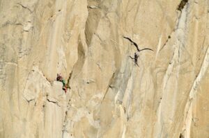
(CCoetzer/TSjogren) During 1985-86 Piotr Chmielinski became the only member of the 13-person Amazon expedition who managed to navigate the river entirely from Source to Sea. He covered the distance all the way, kayaks and rafts, the first person ever to do so.
26 years later, In 2012 with Google Maps available, a controversy flares up about the true source of the Amazon River.
As previously reported on Explorersweb, Outside Magazine wrote in January 2013, “New evidence, currently under review by a respected scientific journal, makes the case that the tributary where Chmielinski and Kane put in, the Apurimac, isn’t the true source of the river. […] Last winter a San Diego whitewater-kayaking guide and former neuroscientist named James “Rocky” Contos, 41, was using Google Earth to plan a trip to Peru, to run the five major headwaters that feed the Amazon. As he plotted each of their lengths via GPS, he decided that the Mantaro, north and west of the Apurimac, was the real source.”
Furthermore, Canoe and Kayak ran a story about the discovery and rivalry of the true source of the Amazon.
Pythom asked Piotr Chmielinski, the Godfather of Amazon exploration, to shed light on the matter and also compare his 1985 expedition to present times.
PYTHOM: Tell us about the source of the Amazon please.
PIOTR: The Amazon is a very interesting river and I guess one of the most complicated in terms of localization of its source/sources.
Based on information of National Geographic Society (see: Jane J. Lee, Where Does the Amazon River Begin? https://news.nationalgeographic.com/news/2014/02/140213-amazon-river-length-source-maps-science/) the recognized, which means constant, permanent and most distant source of uninterrupted flow) source of the Amazon is located in the Lake Ticlla Cocha where Apurimac River begins. It is called the constant source with the most distant continuously water run.
The seasonal source in Cordillera Rumi Cruz – where Mantaro River starts, is the most distant not-continuously water run. It becomes the most distant source only during rainy season. This source was established by Rocky Contos in 2012-2013 (see: Correct placement of the most distant source of the Amazon River in the Mantaro River drainage – Contos – 2014 – Area – Wiley Online Library) and Rocky, together with James Duesenberry, did first descent of the Mantaro River in 2012. I was very impressed with this achievement.
Some explorers maintain that the Amazon River begins from the Maranon River (based on the volume of water – hydrological source). The Maranon River is called sometimes the historical source of the Amazon.
PYTHOM: How does an Amazon expedition in 1985 compare to one in 2015? How are they different and how the same?
PIOTR: Certainly in 2015 the Amazon River is better known than in 1985. Our expedition from the source to the mouth of the Amazon made the first research of the river, particularly of the places that had probably never been “touched” and visited by human. We had maps that were far from precise localization of some points, so very often we had to trust our intuition, experience and local inhabitants.
The last 30 years became a time of changes, particularly in the area of technology. Today expeditions are equipped with GPS, SPOTs to be properly directed as well as in communication devices: mobile phones, satellite phones, in some places Internet connection to have contact with the world. The equipment, also kayaking equipment, makes the most significant difference if you want to compare expedition of 2015 to 1985 one.
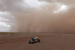
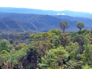
What is the same? The river. It is still the same wild, dangerous in some points, always beautiful and fascinating, Amazon. The area, especially in the upper section that I had an opportunity to visit recently, almost hasn’t changed – wild nature untouched by the man, open spaces, terrain making you feel completely isolated from the outside world.
PYTHOM: Such an expedition on the Amazon seems to be a logistic nightmare. Permits and permissions and supplies. What does it involve to organize such an expedition and how long does it typically take?
PIOTR: You must prepare very carefully for such an expedition. You have to take care of each detail, predictable detail of the trip. You must gather as much knowledge on the country you are going to visit as possible: its geography, culture, politics, people, customs, main hazards etc. There are many things that should be organized in parallel.
It is important to check what permits or documents are needed to make the travel possible in the districts to be crossed during the journey. Some parts of Peru are indeed closed for tourists and explorers, so you need a permission to enter this area. Sometimes it takes several weeks to get such a “passport” in the form of a written permission or just a company of indigenous representative.
Sometimes you have to decide if it is worthy to enter areas restricted by the government to pass, as we did in 1985 crossing Ayacucho department controlled by Sendero Luminoso. In our case we had to take that risky decision to accomplish the expedition goal.
At the same time, the necessary equipment and supplies should be collected based on the knowledge of the terrain and weather conditions of the area to be crossed. It must be well planned, as you cannot take too much with you because of the lack of space in the kayak, and too little to let you survive in the area far from human agglomerations.
Usually, organizing these aspects of the expedition takes several weeks or months. However, this is nothing without experience and skills in kayaking on the white water. It takes much longer to learn and practice kayaking techniques to be able to run in extremely dangerous conditions on the river crossing the high mountains as well as to build own mental and physical strength to be able to paddle almost 7,000 km of the Amazon.
BACKGROUND:
During the 1985-86 Amazon Source to Sea Expedition, Piotr Chmielinski became the only member of the 13-person expedition who managed to navigate the Amazon River entirely from Source to Sea, about 4300 miles. Joe Kane completed the entire river by walking the first section of the Apurimac’s white water and finished the rest by kayak and raft. Zbigniew Bzdak and Kate Durrant completed the entire River by walking the first section of the Apurimac’s white water and done rest by raft and motor boat. Their adventure is described in the book Running the Amazon by Joe Kane, which is now considered a classic of adventure literature.
During a 1979 expedition, Chmielinski became the first person to kayak Colca Canyon, the world’s deepest canyon.
Previous: Piotr Chmielinski, Godfather of Amazon exploration (Interview Part 1 of 3)
Next: Piotr Chmielinski: Running the Amazon, 30 years on (Interview Part 3 of 3)