Central Asia’s top spots for adventure, how to get there, and what to expect from Kazakhstan, Kyrgyzstan, Tajikistan, Uzbekistan, and Turkmenistan.
Central Asia’s five countries cover an area nearly twice the size of Greenland. It includes two of the tallest mountain ranges in the world, the Pamirs and the Tien Shan, and some of our largest deserts. Because of holdover habits from the old Soviet era, parts of Central Asia see few visitors. If, as Paul Theroux writes, the best travel is a form of trespass, here’s how to trespass in a special part of the world.
Travel Basics
According to the World Tourism Organization, the number of international visitors to Central Asia has increased dramatically since records began in 1995. Tajikistan has seen the biggest increase, from 700 people a year to more than a million in just over two decades. Only Turkmenistan has fewer visitors: from 218,000 in 1995 to less than 10,000 in 2007, which is its most recent record.
In most cases, travel in Central Asia is relatively straightforward, via an extensive network of roads, railways, and airports. However, overland distances are deceptively long. For example, driving between Almaty in south-central Kazakhstan to Aktau in the far west of the country takes more than two full days and is farther than from London to Istanbul.

A horseman crosses rickety bridge over a glacial torrent in Kazakhstan. Photo: Jerry Kobalenko
Kazakhstan
The world’s largest landlocked country, vast stretches of scrubby steppe, sandy deserts, and salt flats dominate Kazakhstan. Mountain-wise, there’s part of the Altai range in the east and the Ili-Alatau and Dzungarian ranges of the Tien Shan in the south. It’s the most economically advanced nation in Central Asia, but outside the towns, there’s plenty of ancient cultures and wild country to explore.

The Ustyurt’s Karyn Zharyk Depression, Kazakhstan. During freak rainstorms, the basin can transform into a lake. Photo: Matthew Traver
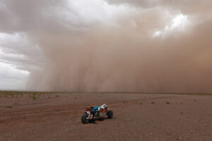
- Ustyurt Plateau — Roughly the size of Scotland and England combined, the Ustyurt Plateau is Eurasia’s answer to Arizona’s famed Monument Valley, but 550 times its size. Central Asia’s remotest place, it is shared by Kazakhstan, Turkmenistan, and Uzbekistan. Less than 13cm of rain fall per year. Because of its continental climate, temperatures range from −40°C in winter to above 40°C in summer. Dead-flat salt pans, rocky pinnacles and badland valleys wait to be explored on foot, by bike or by more imaginative transport, such as camels.

A rusting ship lies beached on what was once the Aral Sea. Photo: Jerry Kobalenko
- Aral Sea — Spread between Kazakhstan and Uzbekistan, the Aral Sea was once the fourth largest lake in the world. In the 1960s, the Soviet Union diverted the Syr Darya and Amu Darya rivers to irrigate the cotton fields, depriving the Aral Sea of its only two sources of replenishment. Within 30 years, 90 percent of this shallow, saltwater lake had dried up. By 1987, it had split into two separate bodies of water: the North and South Aral Seas. The southern half has dried up completely and is now known as the Aralkum Desert. The good news is, a dam built in 2005 in Kazakhstan has increased the North Aral Sea’s level by three metres. Eco-crisis aside, the Aral holds plentiful opportunities for anyone looking to explore a seriously saline and inhospitable environment. Be aware that strong winds can whip up a toxic mix of salt, sand, and Soviet-era pesticides and fertilizer, which can cause severe lung and throat problems. ExWeb’s editor, Jerry Kobalenko, once tried to hire a plane to take aerial shots of the Aral Sea and desert. One of the airport guys insisted on contacting the authorities to make sure that it was ok to rent a plane to a foreigner. It was not. It turned out there was an anthrax weapons factory nearby, possibly decommissioned now, and he was kicked out of town.
Kyrgyzstan

Atop a 4,000m pass in the Tien Shan, Kyrgyzstan. Photo: Jerry Kobalenko

Trekking in Kyrgyzstan. Photo: Jerry Kobalenko
Of the five Central Asian republics, Kyrgyzstan sees the most adventure travel. Roughly half the size of Sweden, the country embodies all that’s iconic about Central Asia: remote yurts in grassy fields, 7,000m peaks, herders on horseback tending flocks of sheep, and ample opportunities to kick back with the Kyrgyz over kumis (fermented mare’s milk) and beshbarmak (chopped meat and noodles in onion sauce).
- Ak-Shyyrak Range — On the edge of China’s western border, the Ak-Shyyrak mountains lie in one of the remotest corners of the country, at least one full day’s drive from the capital, Bishkek. It has plenty of first ascents of 4,000 to 5,000m peaks and countless little-explored valleys.
- Kel Suu Lake — Tucked away in a distant corner of the Tien Shan mountains, near the Kok Kyia Valley, lies Kel Suu Lake. It’s 15km long, accessible only by foot or horseback, and surrounded by 800m rock walls. Until a few years ago, it was relatively unknown, but its picturesque views have given it some popularity of late. Yet in the last 20 years, the lake has twice lost most of its water. Unlike the Aral Sea, the reasons for its desiccation are unknown, but it’s thought to have been caused by an underground collapse. Although this is not the most “out there” location on this list, Kel Suu Lake serves as an example of the many possibilities for little-known gems hiding in Central Asia’s bountiful backcountry.

Fishing a creek in the small town of Sary-Tash, Kyrgyzstan. In the background are Tajikistan’s Pamirs. Sary-Tash’s two roads lead south to China via the Irkeshtam Pass and west to Tajikistan via 4,000m Kyzyl-Art Pass. Photo: Matthew Traver
Tajikistan

Pamir foothills, Tadjikistan. Photo: Jerry Kobalenko
The smallest of the Central Asian republics, Tajikistan has the highest average elevation of any country in the world (2,954m). The Pamirs cover more than 90 percent of it. Only the southeast part is relatively flat. Bordering the poppy fields of Afghanistan, almost half of Tadjikistan’s economy comes from drug smuggling.
- Fann Mountains — Part of the western Pamir-Alay range, the 4,000 to 5,000m peaks in the Fanns have for decades trained Russians and other climbers from the former Soviet Union. Although most of the main summits have already been climbed, opportunities abound for more technical rock and ice-first ascents. Despite its potential, it remains a relatively quiet destination, aside from a handful of trekkers and climbers during the high season. Most trailheads are accessible by car from Dushanbe, Tajikistan’s capital.

A remote valley in eastern Tajikistan. On the other side of the snowy peak lies Lake Zorkul, the source of the Amu Darya River, which flows into the Aral Sea. Photo: Matthew Traver
- Pamir Mountains — With over a hundred 6,000m peaks, the Pamirs have many remaining first ascents, pioneering ski descents, and adventurous treks. Access takes a minimum of two days via the world-class Pamir Highway from Osh, Kyrgyzstan, or Dushanbe. The M41, as it’s also known, is the only road through eastern Tajikistan and connects Osh with the Tajik capital. Most of the Pamirs is within the Gorno-Badakhshan Autonomous Oblast (GBAO), and because of political unrest in the recent past, anybody planning to go first needs to secure a permit. This can be done at the same time as your visa application. The GBAO is also the only way to access Afghanistan’s Wakhan Corridor, via the Ishkishim border crossing.
-

A Wakhi herder descends from a high valley in Afghanistan’s Wakhan Corridor, one of the most difficult-to-reach places in the world. Photo: Matthew Traver
Turkmenistan

The Turkmenistan side of the Ustyurt Plateau. Photo: Jerry Kobalenko
Turkmenistan is the most logistically difficult of the five to visit. It’s kind of a Central Asian North Korea. A local agency must issue a letter of invitation before you can obtain a visa. While this is easy enough to arrange, your request may be rejected for unknown reasons. Tourist visas usually cover a maximum of 10 days. Independent travel outside the capital of Ashgabat is difficult to impossible. But isn’t that part of the challenge of adventure?
Until 2006, the country was ruled by bizarre dictator Saparmyrat Niyazov. Among Niyazov’s hijinks, he built golden monuments to himself and renamed the word “bread” after his mother and the months of the year and days of the week after other relatives. His successor, while a little less eccentric, holds a yearly beauty contest for horses. And he keeps tight control of the number of visitors coming in and the citizens going out.

A woman in traditional clothes milks a camel in Darvaza, Turkmenistan. Photo: Jerry Kobalenko
- Kara Kum Desert — Occupying 70 percent of the country, the Kara Kum, meaning black sand, is one of the least-visited parts of the country. Few venture beyond edges of the two highways that cut north-south through the country. Outside of the main towns, all visitors to Turkmenistan must travel with a government-assigned guide. A two-person, vehicle-supported desert trip costs at least $250 to $350 per day.

Kopet Dag Mountains. Photo: Jerry Kobalenko
- Kopet Dag Range — Spanning 650km along the Iranian border, Mount Rizeh (2,940m) is the highest peak on the Turkmenistan side and Mount Quchan (3,191m) on the Iranian side. Intriguingly, it has a ski resort too, although there is barely any snow — another project of the wacky former president. Nevertheless, the range has plenty of untapped opportunities for non-technical peak bagging and long treks through lush valleys, beginning from the village of Kunya-Kumbez.
- East Caspian Coast — There’s no pretending. ExWeb knows very little about what lies on Turkmenistan’s remote Caspian Sea coastline. What we do know is that the nearly 500km long coast has considerable stretches of remote dunes and the Israel-sized Garabogazköl, which is the world’s largest salt lagoon. Near to the lagoon are the wild, Mars-like canyons of Yangysuw and Yangykala.

A Turkmen man wears a large sheepskin hat called a telpek. Photo: Jerry Kobalenko

Pumpjack in Turkmenistan’s oil-producing region near the East Caspian Sea. Photo: Jerry Kobalenko
Uzbekistan

Jamie Maddison (centre left), a British ultra-runner, runs past sandy-scrubby dunes in the Kyzyl Kum. Photo: Matthew Traver
With blue-tiled mosques, desert forts, medieval cities, and camels traipsing around the deserts, Uzbekistan is Central Asia’s most exotic country.
- Kyzyl Kum Desert — Meaning red sand in Turkic, this desert is the same size as Finland. It spreads into both Turkmenistan’s Kara Kum and a desolate 450km-wide patch of dunes and salt flats south of Kyzylorda, Kazakhstan. Nurata, on the southern edge, and Nukus in the country’s west, are the two main starting points for any jaunts into the desert. It’s possible to hire camels from nearby yurt camps, too. It’s also worth visiting three of the country’s most fabled cities — Samarkand, with its stone-tiled madrasahs in Registan Square, Bukhara’s markets — home to the world’s cheapest saffron and its best melons — and the 1,500-year-old city of Khiva.
- Pskem Mountains — Tucked in the northeast, they form a natural border between Kyrgyzstan to the south and Kazakhstan to the north. Many 4,000m peaks flank a 160km-long finger valley. Mount Adelung (4,301m) and Beshtor (4,299m) are its highest points. The trailhead begins in Pskem village, a 140km, six-hour drive from Tashkent. Yes, it’s slow going on those roads.

A Kazakh woman and her child outside their family home in the Kyzyl Kum. A number of Kazakh villages dot this Uzbekh desert. Photo: Matthew Traver
How Did Central Asia Begin?
Our archaic human ancestors, the Neanderthals and Denisovans, first inhabited Central Asia over 200,000 years ago, followed by Homo sapiens 40,000 to 50,000 years ago. Between the seventh and fifth millennium BCE, several cultures developed on Central Asia’s periphery. One of the earliest was the Mesolithic hunter-gatherers of Siberia’s Lake Baikal.
Following this, copper-smelting Chalcolithic cultures scattered across the Pontic-Caspian steppe, which stretches between the Black Sea and northwestern Kazakhstan. Here arose one of the ancient world’s most important innovations: the domestication of the horse. This gave rise to pastoral nomadism and let riders seek out new pastureland in previously unpopulated areas.

Remnants of a desert trap slide off the edge of an escarpment in the Ustyurt, western Kazakhstan. Radiocarbon dating indicates it could be more than 2,000 years old and only fell out of use in the early 20th century. Hunters used to drive big game, such as the saiga antelope, into these rock corrals. Photo: Matthew Traver
By the first century BCE, the Fergana Valley — encompassing Uzbekistan, Tajikistan, and Kyrgyzstan — developed into the major trading hub for the Silk Road network. The steppe nomads traded regularly with the Sogdian people, who controlled the area.
Eventually, the First Turkic khanate became the dominant power in Central Asia. A mix of Turkic confederations and Arab incursions followed until the Mongol Empire came into power in the 13th and 14th centuries.
By the late 19th century, the Chinese Qing dynasty and the Russian Empire had gained control over most of Central Asia. After the Russian Revolution, it was subsumed into the Soviet Union.
From the ashes of the USSR arose 15 sovereign countries, covering a sixth of the world’s land surface. In the middle of this fresh territory stood the five Central Asian nations: Kazakhstan, Uzbekistan, Turkmenistan, Kyrgyzstan, and Tajikistan. There are many local languages, but Russian remains the lingua franca.
Exploration
From prehistoric times, newcomers to Central Asia sought areas mild and wet enough to support animal husbandry and farming.
Given the region’s incomprehensibly long prehistory, we’ll never truly know who discovered what first, or why. No one is sure whether the ancient Greek historian Herodotus, considered the world’s first travel writer, ever visited Central Asia, but in his nine-volume work, The Histories, he describes the nomadic Scythian culture in what is now Central Asia. However, some historians consider his account apocryphal.

The 11th-century Bazar Dara caravanserai in eastern Tajikistan is one of Central Asia’s many archaeological sites. All that remains now is the base of the outer and inner dividing walls. At its height, 300 people lived here and worked in a silver mine higher up on the right. Photo: Matthew Traver
Fast forward through the centuries and countless other writings about early Central Asian journeys emerge, from Alexander the Great’s conquests to Chinese diplomat-explorer Zhang Qian’s second century BCE travels in Kyrgyzstan, Tajikistan, and Uzbekistan. Contemporary explorers such as Sven Hedin, Aurel Stein, Nikolai Przhevalsky, and John Wood explored partly on behalf of the Great Game, the British and Russian Empires’ long rivalry over Central Asia.