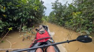
On March 10, Will Copestake and Seumas Nairn began their 880km kayak expedition from Punta Arenas to Cape Horn. After a successful first seven days, their plans unraveled when the Chilean Navy abruptly revoked their permits to paddle around the Cape.

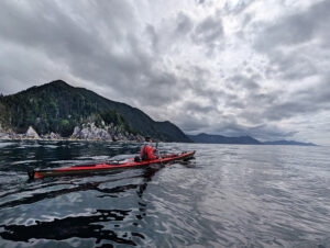
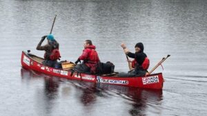
The route. Photo: Cape Horn Kayak
This was Copestake and Nairn’s third expedition in Patagonia. In 2015, they paddled from Puerto Eden to Puerto Natales, and in 2016 they continued from Puerto Natales to Punta Arenas. This third and final section would take them around Cape Horn, something Copestake had wanted to tackle since hearing stories of the infamous Cape.
“The whole idea of Cape Horn was a personal test of mastery. Having spent almost a decade working in Patagonia [as a kayaking guide], it’s long been on my list,” Copestake said.
The first two trips allowed Nairn and Copestake to refine their skills for the additional difficulties they would face around the Cape.
“You’ve got unpredictable wind throughout Patagonia,” Copestake explained. “It can go from 0mph to more than 60mph within a minute or two. In the fiords, it is manageable. The step up for Cape Horn is not the Horn itself, but about a week before that, you have to paddle a significant 16km open crossing.
The alternate crossing to the north is realistically 35km before you can land. If you combine the wind’s unpredictability with those open crossings, you need the skills that we have been developing over a decade of guiding. There is the ability to see and predict what the weather is going to do from cloud movements. It’s almost another sense, you take in all the small environmental signs that are happening around you.”

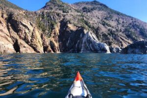
Photo: Will Goodall Copestake
Tricky logistics
The hardest part of the trip was the planning. Copestake and Nairn wanted to complete this expedition years ago, but the pandemic stymied their plans. In the end, they spent four years working to secure the permits which became their downfall.
The Chilean government required permits for each of their expeditions, but each time the requirements had been more extensive.
“The first trip required a kit inspection and an overview of the route,” said Copestake. “Then for the second, they required an in-person PowerPoint presentation, which was quite fun in my limited Spanish.
“For this final expedition, we had to detail every possible contingency plan, introduce your team members and experience, and provide a complete packing list, including a food plan sufficient for the duration. They give you a sort of tick list for the contents of your medical kits and your repair kits. They need to know you’re self-sufficient. You break the trip down into daily legs and you have to mark three or four campsite options that are optional stops, should the weather not allow you to paddle.”

Photo: Will Goodall Copestake
Other difficulties included procuring dried meals and flares, both of which turned out to be very tricky to get in Chile. Dried meals because they are hard to come by, flares because you need several police checks.
An extremely fast start
They completed the first two-thirds of their planned route in the blink of an eye, covering 525km. The pair started north of Cabo San Isidro, paddled to Cabo Froward, and then crossed the Strait of Magellan. They had estimated they would paddle 28km per day but actually averaged between 35km and 45km. By the end of the second day, they were a full 24 hours ahead of schedule.
Speaking to ExplorersWeb, Copestake explained their conservative estimates. “We had underestimated our distances deliberately. You then buy yourself more time for the weather. We explained this to the authorities and they were on board [with the plan].”
This approach worked in their favor early on, when they needed two extra days for the five-kilometer portage between Monte Sacramento and the Darwin Ranges. Nairn and Copestake needed to make it to Puerto William and begin paddling the Beagle Channel, but the hike took three days. It turned out to be the most physically challenging section of their trip.
“On the map, it was five kilometers, but we clocked just over 30km. We were dragging everything through gorse bushes. All very dense, spiky terrain, which was excellent fun, but quite long. It took about a week before we could fully open our hands again.”

A long portage. Photo: Will Goodall Copestake
The end of Beagle Channel
When they arrived in Bahia Oceania, at the western end of Beagle Channel, they were devastated to discover that they could not continue. On entry, the Chilean Navy contacted them to say that they required a support boat to continue to Cape Horn.
What made this particularly galling was that they had asked if they needed a support boat (and had been happy to arrange one) when they originally applied for their permits. The Navy told them they did not require one.
Trying to figure out what had changed using 160-character messages on their satellite phone was incredibly frustrating. “It was just crazy. We got a text message saying, ‘Oh, you can’t do this anymore’, and we can’t really argue it ourselves or hear the full reasons.”
“Had they given us the time, we would have either changed our route or organized [a support boat]. But to do that via SAT phone…would have been almost impossible,” Copestake explained.

Photo: Will Goodall Copestake
Break the rules or turn back?
They had the physical permits in hand, but these were now worthless. No amount of discussion helped, and the Navy told them to return to Puerto William. Unable to negotiate, they were left with a choice: continue without permission, or follow the Navy’s instructions.
People do kayak around the Cape without permits. Paddlers simply set off and don’t tell anyone. But Copestake and Nairn tried to conduct their expedition professionally and feel that they were penalized for doing so.
After much discussion, they decided not to break the rules. Over the next 14 days, they took the scenic route back to Port William.
“It was a change of pace. [The Navy] demanded we come back post haste, but they can’t actually say that because if you speed up and die, it’s on them. We knew that and they knew that. So we took the opportunity to detour and see some glaciers and fiords, knowing that they couldn’t really argue with us.”

Photo: Will Goodall Copestake
Never again
Copestake and Nairn say that they don’t see themselves attempting Cape Horn again. They feel betrayed by the Chilean Navy, and Copestake is in the process of writing up a formal complaint.
Now back in Scotland, Copestake is planning out his next few months.
“I have a fantastic summer ahead with lots of paddling all over Scotland, a possible return to Patagonia in November, and a few trips in Antarctica in January…
“The Horn has at the very least been a phenomenal exercise in expedition planning. I’m very confident we would have made it had the Navy allowed us.”

Photo: Will Goodall Copestake