The Himalaya’s long spell of good weather turned poor today, but eager climbers still summited Cho Oyu. The low visibility made it hard to find the real summit since it lies somewhere in the middle of a huge snow plateau with no rocky features for reference.
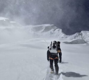
Descending in poor visibility
Sirbaz Khan and Naila Kiani, climbing with Imagine Nepal, summited in a single push. Both Pakistani climbers reached Advanced Base Camp at 5,700m on Saturday, then set off on Sunday at 8:30 am.
They rested for three hours at Camp 1, by which time the weather had soured. Nevertheless, they climbed nonstop through the night, progressing slowly, especially through the Yellow Band.
At the moment of posting this story, the climbers were on their way down. We will update once they safely reach Base Camp.
Khan climbed without supplementary oxygen. In total, they took 28 hours from Base Camp to the 8,188m summit. Their home team noted that they made sure they had reached “the two official summits of Cho Oyu.”

The route followed by Sirbaz Khan and Naila Kiani on Cho Oyu, compiled by Samson Sharaf on a Google Earth 3D map, from the GPS points sent by Kiani.
Chinese or Nepalese summit?
Two official summits? The Nepalese and the Chinese have different GPS coordinates marking the “true” summit of Cho Oyu — meaning, the highest point of the huge summit plateau. Climbers on the normal route reach a “false summit” where the final snow ramps give way to flatter terrain. In order to reach the highest point, they have to keep walking on the nearly flat plateau for at least another hour.
Before GPS and satellites, summit pictures had to include a good view of Everest in the background. Today, modern technology gives more exact points, but disagreement among nations sometimes remains. According to the Nepalese, Cho Oyu is 8,188m; for the Chinese, Cho Oyu — or Mt. Qowowuyag, as they call it — is 8,201m.
In a comment to a previous ExplorersWeb story about Cho Oyu, Australian climber Jamie McGuinness noted what he discovered in 2004 when he summited Cho Oyu for the fifth time: “I stood on top with a Garmin GPS, and an averaged set of 50 readings with 12 satellites at full strength gave me 8203m — twice, perhaps half an hour apart. I held the GPS above my head.”
McGuinness also disagreed with the traditional belief that the summit was where Everest was visible. “At the lower edge of the plateau, you can see Everest but are most definitely not at the summit. It is still further up the ridge and also has views of Everest…You must be able to see Everest and the lakes of the Gokyo Valley to be on the summit.”
But traditional methods to assess the summit are useless in poor visibility, including earlier today.
Chinese summits
A large Chinese expedition on Cho Oyu is combining climbing and research. Yesterday, 18 of them installed a solar-powered, automated weather station on the summit, taking full advantage of the last day of good weather. It should work for the next two years.
During the climb, they also drilled ice cores and collected snow samples from different altitudes to study climate change and melting glaciers.

Chinese researchers measured the thickness of the ice layer on the summit of Cho Oyu yesterday. Photo: Xinhua News
One researcher, Yao Tandong, explained the uncertainty about the exact altitude of Cho Oyu.
“The summit of Cho Oyu is particularly broad, similar to a football field,” Yao said. [This] is very rare among the highest peaks in the world. Preliminary research revealed that the maximum ice thickness is the greatest of all the peaks above 8,000m, with a visual thickness of over 70 meters.”
The topic of true summits has recently inspired a heated debate about certain climbs done years ago. New, more exacting standards — based on research by 8000ers.com — are now reappraising these historic climbs. But Cho Oyu’s summit has always been particularly controversial since the photographic evidence on which Jurgalski’s team bases its conclusions is not an option. The summit is huge, flat, snow-covered, and largely without detail.
If not for its thick summit snowfield — if Cho Oyu’s altitude was measured only by its rocky base — it would be still an 8,000er, just not the 6th highest peak in the world. It would be lower than Manaslu. Likewise, variations in annual summit height can depend on the year’s snowfall and temperatures.

The broad summit of Cho Oyu, where the Chinese expedition installed an automated weather station yesterday. Photo: Xinhua News
Yesterday’s summit team was only a part of the 120 scientists who are conducting research on water, ecology, and human activities around Cho Oyu, Xinhua News reported.
Last stages for 14x8000m collectors
Being strict about the precise summit is particularly important for Sirbaz Khan. He now has only Shishapangma in order to become the first Pakistani to complete the 14×8,000’ers. He has done most of them without bottled oxygen. For fellow Pakistani Naila Kiani, Cho Oyu was her 10th 8,000m summit.
Seven Summit Treks has a group of 14×8,000m collectors in the final stages of their list. They entered Tibet over the weekend. Among them, Adriana Brownlee, with 12 peaks, Gelje Sherpa, who has only Cho Oyu left to do, and Grace Tseng of Taiwan. Some of Tseng’s claims have raised questions, and she has been absent from the scene of late. But she still has the opportunity to become the first Taiwanese woman to summit all 14.

Climbers in Tibet on their way to Cho Oyu Base Camp yesterday. Grace Tseng is on the left with a white T-shirt, and Adriana Brownlee stands on the right in a blue down jacket. Photo: Seven Summit Treks
On the Nepal side of the mountain, the Russian team is back in Gokyo village after an exploratory trip to 5,650m on Gyazumpa Glacier. They had hoped to study possible routes, but bad weather killed the visibility. Now they’ll rest for a couple of days and decide about their next steps, said leader Andrei Vasiliev.
The poor weather on both the Nepalese and Tibetan sides of the Himalaya is forecast to continue until Friday.