In this series, we look at the world’s five highest unclimbed mountains, based on Eberhard Jurgalski’s list from 8,000ers.com. We will cover each peak’s modest climbing history and why no one has summited them yet.
As noted previously, this series covers independent mountains — those that are not just secondary bumps on higher main peaks. The debate about subsidiary peaks versus independent mountains is a recurrent headache when climbers search for the “highest unclimbed peak.” Some sources, for example, grant this to Muchu Chhish. But Muchu is part of the Batura Range and has just 263m of prominence and 3.5% dominance. Most do not consider Muchu Chhish independent.
Here, we will be covering those unclimbed peaks for which there is no debate.
Our second peak is 7,250m Lapche Kang II.

The Pamari Himal photographed from the International Space Station. Lapche Kang II is marked with a red dot. Photo: Nasa/Gunter Seyfferth
A remote corner of the Himalaya
At 7,250m, Lapche Kang II is the 91st-highest peak in the world and has a prominence of 570m. It is located in Tibet, in the northern Himalaya, about 35km northwest of Cho Oyu. It forms part of the Lapche Kang massif.
This section of the Himalaya is not well known. According to Gunter Seyfferth at Himalaya Info, the region has almost no detailed maps. Only a few teams have attempted the peaks here and therefore it is important to mention some of the first climbs in the massif, starting with Lapche Kang I.

Lapche Kang (center) and Shishapangma (in the background to the left) photographed from Cho Oyu (looking east-northeast). Photo: Dirk Groeger
Lapche Kang I
The highest summit in the massif is 7,367m Lapche Kang I (also known as Choksiam, Labuche Kang, or Labgye Kung), with a prominence of 1,957m. This peak was the first reconnoitered in the group.
In the post-monsoon period of 1986, four members of a Chinese-Japanese team ascended to a col at 6,200m. From there, they saw a suitable route via the west ridge. The party noted that the north face and the north ridge were quasi-impossible to ascend.
One year later, in 1987, a team of nine Chinese and nine Japanese alpinists approached the mountain from Langgoloz village. They established their advanced base camp 21km up the valley at 5,300m.

The Lapche Kang massif is about 30km north of the Nepal-Tibet border. Photo: Summitpost
Camp 1 was on a snow plateau at 5,600m and they pitched Camp 2 at 6,150m on a hanging glacier on the northwest face. From there, they reached the west ridge of Lapche Kang I, fixing ropes as they went.
On October 26, four Tibetans and four Chinese climbers completed the first ascent of the mountain. More climbers from the team made the summit on October 27.
After 1987, there were no other attempts on Lapche Kang I until 2010. American Joe Puryear’s climb ended in tragedy, when he died in a fatal fall.
Name confusion
Lapche Kang II was not on anyone’s radar during the first ascent of Lapche Kang I. But as they carried out the first ascent, the Sino-Japanese team realized that there was another prominent summit nearby. They called this sub-peak, just off to the west and measuring about 7,072m, Lapche Kang II. A Swiss party later ascended the sub-peak in 1995.
However, that secondary summit was not the second-highest peak in the massif. East of Lapche Kang I lies a peak measuring 7,250m. Logically, the names were eventually changed and the 7,250m mountain, considered an independent peak, became Lapche Kang II.
There is possibly another secondary summit a little further east, approximately 7,120m high, but this is not confirmed. If eventually confirmed, then this 7,120m summit might become Lapche Kang III and the current Lapche Kang III (7,072m) would become Lapche Kang IV.

Views from the south to the central Lapche Himal. Photo: Gunter Seyfferth
The only attempt on Lapche Kang II
The first and only attempt at Lapche Kang II came in 2016. On September 6, a Polish team arrived in Kathmandu, Nepal.
Krzysztof Mularski, Maciej Przebitkowski, Jakub Rybicki, and Jaroslaw Zurawski believed that they had all the necessary documents for onward travel to Lhasa waiting for them at the Chinese consulate in Kathmandu. But those official documents were not released to two members of the party. According to Mularski’s report for the American Alpine Journal, the authorities made an issue about visas to Muslim countries in their passports. They told them they would only be able to continue to China in 10 to 12 days.
While they waited, the Polish party decided to start trekking in Langtang. On September 17, they finally flew on to China.

Tingri County in Tibet. Tingri means ‘calm voice hill.’ Photo: TripAdvisor
They reached Tingri (located in the south of the Tibet Autonomous Region) on September 20. There, despite the arrangements promised by the Tibet Mountaineering Association, the authorities told them they were not allowed to approach Lapche Kang II from the north via the Choksiam Glacier. Instead of the northern route, which the Polish climbers considered the easiest option, the authorities told them to approach the peak from the east, up the East Lapche Glacier.
The climbers drove to Cho Oyu Base Camp, and on September 23, they started up the glacier.

Camp 1 on the East Lapche Glacier at 5,500m. The Polish team’s attempted route is marked in red. (A) is Lapche Kang II Main (7,250m). Photo: Krzysztof Mularski
The climb
At 5,400m, Mularski’s team set up an advanced base camp, followed by camp 1 at 5,500m. Next, they fixed some rope up a section of WI2 and established camp 2 at 6,150m below a steep, snowy rib that lead to an upper terrace at 6,400m.
They put camp 3 at 6,600m, a little above the terrace. From there, on October 12, Rybicki and Mularski made a summit attempt on Lapche Kang II.
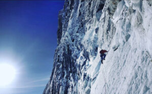
The summit push was difficult. The route took them up a 65° snow/ice face to 6,907m. After a long slog, they decided to retreat as they felt that there was no chance of reaching the summit before nightfall. In dangerous, unknown terrain, it was a smart decision.
Short on time, the Polish team then returned home, leaving this elusive peak unclimbed.

A new sketch map of the main area of the Lapche Kang massif, showing the routes taken by the 1987 Chinese-Japanese, 1995 Swiss, and 2016 Polish expeditions. Map: Jerzy Wala
Lapche Kang II remains unclimbed
Because of the confusion around names and the difficulty accessing Tibet, it is perhaps unsurprising that Lapche Kang II remains unclimbed. China has reopened since COVID, but it is impossible to know if Lapche Kang II is accessible for climbers until a team requests permits. It is already seven years since the only attempt, and Lapche Kang II remains a tantalizing target that could stay unclimbed for many years.