The massive earthquake that hit Japan’s Noto Peninsula on Jan. 1 has had a drastic effect on the peninsula’s coastline. Satellite images show that the quake has moved the coastline further into the ocean.
Inhabitants along Japan’s western coastline felt the 7.6 magnitude quake on New Year’s Day. One-meter waves crashed into the Ishikawa prefecture on Honshu Island, and in Akasaki they reached 4.2m.
The government released tsunami alerts across the region. Thousands of houses lost power, and several buildings collapsed. The earthquake killed 213 people and displaced 26,000.
The earthquake that struck Japan’s Noto peninsula on Monday was so strong that the coastline has moved up to 250 meters offshore due to significant land uplift. pic.twitter.com/XpxBMLRTUU
— Nahel Belgherze (@WxNB_) January 4, 2024
New beaches and dry ports
Recent images show the force of the quake. At ten points along the coast, the coastline shifted significantly, as the seafloor rose above the normal water level. Besides the new beaches, there are also some trapped ports. The ports are now high and dry, and boats can’t access them.
The Japan Aerospace Exploration Agency (JAXA) provided satellite imagery of the changes. Some coastal areas have risen by almost four meters. The rising land may have reduced the tsunami’s impact.

A region of the Noto Peninsula in June 2023 (left) and January 2024 (right) shows coastal expansion from the earthquake. Photo: Geospatial Information Authority of Japan/JAXA
Coastal uplift can happen in two ways, both involving tectonic forces. It can occur very slowly over geological time or rapidly because of earthquakes. When a large earthquake causes vertical movement on a fault line, the land can suddenly shift upwards.
Since Jan. 1, there have been several aftershocks, and the authorities warn that further strong earthquakes could follow over the next month. Already, another 6.0 magnitude quake has added to the destruction.
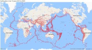
The region lies at the border of four tectonic plates and an incredible 20 percent of all global earthquakes over a magnitude of 6.0 have occurred in this area. This is the strongest earthquake here in four decades.


