Mingma Dorchi Sherpa has already climbed Makalu three times as a guide and knows it well. This spring, he goes for his fourth ascent, after he first leads a Pioneer Adventure team on Kangchenjunga. Before leaving for the mountains, he has shared his knowledge of the route up Makalu with ExplorersWeb.

Last winter, Mingma Dorchi led the attempt to open a new route up Cho Oyu’s SSW ridge. Above, Camp 3 with Everest-Lhotse-Nuptse in the background.
Summit memories
Mingma Dorchi first summited Maklu in 2012, with Chinese client Rao Jianfeng, just a week after reaching Base Camp. They were fresh from another 8,000m ascent and didn’t need to acclimatize. “However, we had no way to shoot good summit pictures, since we reached the top at 7:25 pm!” recalled Mingma Dorchi.
On his second Makalu climb, in 2017, he guided a fellow Nepali named Mr. Nirmal Purja. Yes, him.
“That season, I was not expecting to climb Makalu. My guiding plans were for Dhaulagiri, which I successfully summited. But right after returning to Kathmandu, I received a call from Nims Dai. He was looking for a Makalu summit guide for his team of four. So I went there to assist him and his team of three Sherpas, as none of them had summited Makalu previously.”

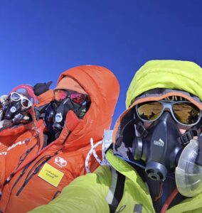
Mingma Dorchi (left) and Dawa Yangzung on the summit. Photo: Pioneer Adventure
Mingma recalls that they flew from Lukla right to BC and reached the summit in just three days.
His third summit was in 2019 with Dawa Yangzum Sherpa — currently an IFMGA guide — and Phurba Kusang Sherpa. It took place right after his speed record from Everest to Lhotse (six hours 1 min, on May 27).
“We summited Makalu on May 29,” Mingma Dorchi said. “So that season, I climbed three 8,000m peaks in 54 hrs 25 min.”
Safe but difficult
“In my opinion, the most distinctive feature of Makalu is that it is one of the safest of the 8,000m peaks,” Mingma Dorchi said. “There is a very low chance of casualties because avalanches are not common. But that doesn’t lessen its technicality.”
At 8,463m, Makalu is the world’s fifth highest mountain. Its normal route goes via the Makalu La and up the NW Ridge. It is known as the French Route since Lionel Terray and Jean Couzy first did it in 1955.
The approach trek
“Nowadays, climbers who opt for doing two 8,000’ers in the same season catch a helicopter straight from Base Camp to Base Camp,” the guide said. “Those who only go for Makalu, however, usually trek to Base Camp.”
Makalu is comparatively remote, so the trails are rough. But the views are great, and the trekkers stay in lodges along the way.

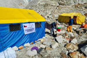
Makalu Base Camp. Photo: Pioneer Adventure
Base Camp lies on the moraine of the Barun Glacier, on the west side of Makalu, at 5,250m. “It is kind of rocky, with ice on the sides,” says Mingma Dorchi. It is usually called Hillary Base Camp.
Base Camp (5,250m) to Camp 1 (6,100m)
A 90-minute walk from BC over rocky scree leads to Crampon Point. Here, climbers gear up, then traverse a flattish ice area, notched with a few crevasses, until about 5,900m. The ice then gets much steeper.
“We start using fixed lines until Camp 1, which is usually set on a plateau above the 200m headwall,” said Mingma Dorchi.

On the way from Base Camp to Camp 1. Photo: Pioneer Adventure
Camp 1 (6,100m) to Camp 2 (6,500m)
“The distance from Camp 1 to Camp 2 takes two to three hours at a normal pace,” Mingma Dorchi said. “The route is all steep climbing, with soft snow and crevasses.” According to a 2014 report by Philippe Gatta (and the photo below), the platform at Camp 2 is wide enough for a large number of tents.

Camp 2. Photo: Pioneer Adventure
Camp 2 (6,500m) to Camp 3 (7,250m)

Above Camp 2. Photo: Pioneer Adventure
Camp 2 to Camp 3 takes six to eight hours for the average climber.
“The route starts flat and slowly becomes steeper,” said Mingma Dorchi. “The going also gets progressively more technical.”
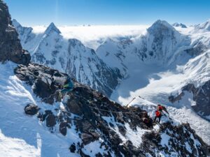
This section involves traversing two rock bands. Camp 3 sits atop the huge Makalu La, the col separating the main peak from the smaller Makalu II.

Approaching Camp 3. Photo: Pioneer Adventure

A rocky section between Camp 2 and Camp 3. Photo: Pioneer Adventure
Camp 3 (7,250m) to Camp 4 (7,400m)
Some climbers are strong enough to launch their summit pushes from Camp 3. But most prefer to set up a fourth camp at the end of a flat, wide plateau, further toward the main peak and within view of the distinctive French Couloir.

Climbers on the way to Camp 4. Photo: Philippe Gatta
This section is flat but very exposed to the wind. Some parts don’t have fixed ropes, just bamboo wands for guidance in poor visibility.
“If you miss those, there is a chance of getting lost,” he says.
Camp 4 (7,400m) to the summit (8,463m)
From Camp 4, the route mounts the glacier until the French Couloir, at about 8,200m. The couloir itself is mixed rock-and-ice climbing, with some difficult sections, until the summit ridge.

A climber, background, heads along Makalu’s summit ridge toward the foresummit. Photo: Pioneer Adventure
“Following along the ridge, the route first goes to a secondary summit,” Mingma Dorchi points out. “From the top of this, the real summit of Makalu is visible, about 120m ahead.”

Makalu’s main summit. Photo: Pioneer Adventure

Mingma Dorchi Sherpa on the summit of Makalu. Photo: Pioneer Adventure
Minga Dorchi warns that some climbers mistake the foresummit for the real summit. Climbers must make sure that there is no other bump ahead of them, and that from there, all ways point down.

Makalu’s foresummit, seen on the way down from the main summit. Photo: Pioneer Adventure

Makalu route on a photo taken by Kumaran Rasappan as she descended from Everest in 2012. Photo shared at https://climbeverest2012.wordpress.com/