In 1911, readers of The New York Times were treated to an incredible story: the rapid advance of the Martian civilization.
Using a 24-inch telescope, Percival Lowell — the businessman responsible for Arizona’s Lowell Observatory — was able to sketch some of the Red Planet’s geography. Unfortunately, he mistook some of its natural features for massive artificial canals built by a fast-growing civilization of Martians.
“We can scarcely imagine the inhabitants of Mars capable of accomplishing this Herculean task within the short interval of two years,” The New York Times wrote of Lowell’s observations on Aug. 27, 1911.
Thankfully, our ability to create detailed images of other planets has improved quite a bit since then.
In just the last month, scientists have released two massive new maps of Mars compiled from thousands of images. And in more good news for astronomy lovers: They’re freely available to the public, and have already been cited in scientific papers for their accuracy.
Two new ways to love Mars
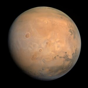
In April, scientists from New York University Abu Dhabi (NYUAD) and the United Arab Emirates (UAE) created a stunning map of the planet’s surface (the one above). It’s based on more than 3,000 images taken during the Emirates Mars Mission. The UAE sent its Hope spacecraft to begin orbiting Mars two years ago.
From the very first image sent back by Hope, it was clear that the new view of Mars was something special, said Dimitra Atri, a research scientist at the Center for Space Science at N.Y.U. Abu Dhabi.
“I was just blown away by the quality of the image showing the full disk. I had never seen Mars like this,” Atri told The New York Times. “These are all natural colors on Mars.”
But that’s not all, folks.
NASA also just released what the space agency calls the most detailed 3D map of Mars ever made. Created by the Bruce Murray Laboratory for Planetary Visualization at the California Institute of Technology in Pasadena, it’s an interactive map of the planet’s surface, not unlike Google Earth.
Named the Global CTX Mosaic of Mars, it’s also a mosaic made from 110,000 images taken by NASA’s Mars Reconnaissance Orbiter. In this case, it’s a black-and-white camera, but the results are no less impressive.

The interactive map of Mars is — in layman’s terms — very cool. Image: Screenshot from Global CTX Mosaic of Mars
Six years, 13,000 images
It took the team six years to stitch together all the images into something usable, with most of them organized using a computer algorithm, Space.com reported. About 13,000 images were added manually by researchers.
“I’ve wanted something like this for a long time. It’s both a beautiful product of art and also useful for science,” said Laura Gerber, a Mars scientist at NASA’s Jet Propulsion Laboratory in California.
There has never been a better time to explore the cosmos — even if you might not find an alien civilization along the way.

