Declassified photos from U.S. Cold War spy satellites show 396 previously unknown Roman forts across Iraq and Syria. Archaeologists believe these photos from the 1960s and 1970s call for a reassessment of Roman life in the region.
More than a defensive wall
Previously, historians believed that the Romans built structures in what is now Iraq and Syria to defend against Arab or Persian attacks. This line of thinking began in the 1930s when French archaeologist and Jesuit missionary Antoine Poidebard took aerial surveys of the area in his biplane. He recorded 116 Roman forts, all built in a line that ran north to south from the Tigris River in Iraq to the Euphrates River in Syria, creating a kind of wall.

The study area. Photo: Casana et al
“Since the 1930s…few scholars have questioned Poidebard’s basic observation that there was a line of forts defining the eastern Roman frontier,” Jesse Casana, lead author of the recent study, told The Guardian.
However, the newly discovered forts do not follow the linear pattern recorded by Poidebard. Instead, the 396 buildings are scattered from east to west. This shocked Casana and his team.
They now believe that the border between the two empires was not as rigid as historians thought. Moving away from the idea of conflict, they think that the Romans built the forts for communication and trade.
As with every society, trade was important to the Roman Empire. The team suggests that the forts supported those traveling for trade, military purposes, or cultural exchange.
“They don’t look like walls meant to keep people out,” said Casana. “They look like they’re placed to facilitate movement.”

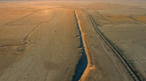
Satellite imagery shows one of the Roman forts. A, B, and C show images from the Cold War satellites, and D is from modern satellites. Photo: Casana et al
Lost to war and construction
Casana believes that Poidebard’s mapping is “the product of discovery bias.” Poidebard only flew his plane on a single route and saw forts in a line. If Poidebard had flown around the entire area he would have found many more. This is where the satellites came in. The Cold War projects’ 149 satellites covered a huge area.
War and construction have destroyed many of the forts. Researchers were only able to identify 38 of Poidebard’s original 119 forts in the photos.