The Second Seven Summits, the lesser-known and more difficult little brother of the Seven Summits, involves climbing the second-highest peak on each continent. In Europe, this means 5,205m Dykh-Tau, one of the most difficult peaks in the Caucasus range.

The Caucasus. Photo: Wikipedia
The Caucasus
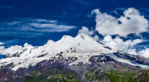
The Caucasus mountains lie between the Black Sea and the Caspian Sea and pass through several countries, including Russia, Armenia, Azerbaijan, and Georgia. It includes two ranges, the Greater Caucasus and the Lesser Caucasus.
The 1,200km Greater Caucasus stretches from near the Black Sea in the east to just north of the Caspian Sea in the west. Earthquakes periodically shake the region. Although some peaks in this range, such as Elbrus and Kazbek, are old stratovolcanoes, there is no actual volcanic activity in the Greater Caucasus.

The Greater and Lesser Caucasus. Photo: World Atlas
All the peaks in the Greater Caucasus exceed 2,000m. In its central part, the huge bastion between Mount Elbrus and Adai-Joj or Ulipata never dips below 4,000m.
The largely volcanic Lesser Caucasus runs parallel for 1,125km through southern Georgia and Armenia, about 100km to the south of the higher range.

The western end of the Greater Caucasus. Photo: B. Loginov and A. Markelov
Europe or Asia?
The Caucasus Mountains are in the center of the Eurasian plate between Europe and Asia. The plate is geologically stable, and it is difficult to determine the continental boundary. That is one reason why the border between Europe and Asia has changed repeatedly throughout history.
In the 18th century, the great Swedish geographer Philip Johan von Strahlenberg declared that the Caucasus mountains were part of Asia. Later, however, the French Grande Encyclopedie drew the border between Europe and Asia to the south of both Caucasus ranges. Based on this, we can say that Elbrus and Dykh-Tau are in Europe. Thus, they do not compete against Everest and the other Asian giants.

The Caucasus. Photo: Paata
Dykh Tau
In the Caucasus mountains, Elbrus is easily the best known. But Dykh-Tau (5,205m), the Jagged Mountain of the Great Caucasus, has an interesting climbing history and is far more difficult to climb than Elbrus.
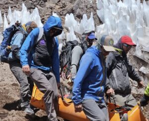
Dykh-Tau is located opposite the famous Bezengi Wall in the Kabardino-Balkaria region of Russia, five kilometres north of the Georgia-Russia border. It is a highly technical mountain and only has a few annual ascents. Avalanches make it particularly dangerous.

The North Face of Dykh-Tau at sunrise. Photo: Vladimir Kopylov
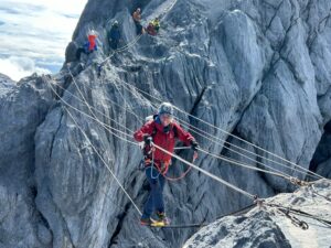
Dykh-Tau has about 10 routes to the summit, none easier than 4A (AD+ in the European system). The normal route goes along the north ridge, which is long, mixed, and very treacherous.
The great British mountaineer Albert Frederick Mummery and his Swiss guide Heinrich Zurfluh first ascended this beautiful mountain via the southwest buttress in 1888.
Mummery
As a mountaineer, Mummery stood out from a young age. He discovered the Alps in 1871 at the age of 16. Following the fashion of the time, he climbed with guides, including Alexandre Burgener, Johann Petrus, and Augustin Gentinetta. In September 1879, Mummery (then 24) and Gentinetta made the first ascent of the Zmutt Ridge on the Matterhorn.
A spate of other successes in the Alps followed: In 1880, Les Grands Charmoz; in 1881, the Aiguille de Verte and the Aiguille de Grepon; in 1887, the Taschhorn along the west-southwest ridge, known as the Devil’s Ridge.

Mummery on the Aiguille de Grepon. Photo: Alpine Mag
Three teams to the Caucasus
In the summer of 1888, three mountaineering parties came to the Caucasus. The first to arrive, in early July, were Mummery and guide Heinrich Zurfluh, accompanied by a Tartar porter.
What drew Mummery away from the Alps to this then-remote place? Perhaps it was the spirit of unrest that he wrote about in his book, My climbs in the Alps and Caucasus:
Though the faithful climber is, in his essence, a thoroughly domesticated man and rarely strays from his own home, the Alps, a spirit of unrest occasionally takes hold upon him and drives him forth to more distant regions.
For two weeks, they studied the topography of the area, crossing high passes and glaciers. Mummery recalled that the Tartar bivouacked without any shelter. Zurfluh was worried that he would freeze. But the Tartar seemed comfortable and spent each night under the Caucasus sky.

The sharp summit of Dykh-Tau. Photo: Mountain Forecast
The climb
On July 23, Mummery and Zurfluh began the ascent of Dykh-Tau after setting up camp at the foot of the southwest buttress. At one point, at a gap in the crest, they had to jump from a higher point to a lower one. Mummery, ascending behind Zurfluh, misjudged the jump and ended up landing badly and slipping.
“Happily this incident escaped the notice of the professional member of the party,” Mummery wrote later.
It is not known to what extent Mummery and Zurfluh were aware of the enormous difficulty of this route through the southwest buttress, but on July 24, 1888, they reached the top of Dykh-Tau.
“Every peak in Europe, Elbrus alone excepted, was below us, and from our watchtower of 17,054 feet, we gazed at the rolling world,” Mummery wrote.
When he returned from the Caucasus, Mummery phased out climbing with guides, eventually becoming the father of modern mountaineering. For him, style, “fair means”, and the delight in “the fun and joy of the struggle” came to take a leading role. Perhaps his struggles on the southwest buttress of Dykh-Tau partly inspired his vision of this new type of mountaineering. And although the name Dykh-Tau is little known today, Mummery’s first ascent was a celebrated achievement in its time.
The second ascent
A few weeks later, a second party arrived in the area to climb Dykh-Tau. The team included British leader John Garford Cockin, H.W. Holder, Hermann Woolley, and two Swiss guides, Ulrich Almer and Christian Roth.
Mummery and Zurfluh’s porter told them that the mountain had been climbed just a few weeks earlier. The news caused great disappointment.

Dykh-Tau. Photo: Advisor Travel
Cockin’s team camped beside the Bezingi Glacier. First, they wanted to ascend the southwest side but they abandoned the idea because of lack of time. Instead, on August 20, 1888, they managed to reach the summit by a new route, climbing the north ridge. This route later became the normal route, though it too is hazardous.
Four days later, the team, except Cockin, made the first ascent of nearby Katyn-Tau (4,979m) via the famously difficult Bezingi Face. Then, on September 3, 1888, the whole team made the first ascent of Saluinan Bashi (4,348m).
On September 4, 1888, Holder and Woolley left for home. The others continued to climb and made some really difficult first ascents (Shkhara, 5,193m, the highest peak in Georgia), the East peak of Jangi-Tau (5,085m), and the North Peak of Ushba (4,695m).

By any route, Dykh-Tau is a challenge for alpinists. Photo: Advisor Travel
A third group and disaster
A third British group was also in the area that season. It included W.F. Donkin, Harry Fox, and two guides. On August 17, they made unsuccessful attempts on both peaks of Ushba. Later they managed to ascend the unclimbed southeast summit of Dongus Orun (4,442m).
Unfortunately, the expedition ended in tragedy during an attempt to climb Koshtan-Tau (5,144m). All four climbers disappeared forever.