As the doomed men of the Franklin expedition abandoned their ships and set out across the windswept ice toward unlikely safety in 1848, they left a breadcrumb of artifacts behind them: personal items, tents, boats, cairns, and — ultimately — graves.
Now, 175 years later, a 71-year-old man sits in a book-filled home office and traces their (possible) route. On his glowing screen, a blurry smear of mottled browns and greys — a satellite photo covering the smallest slice of Canada’s vast northern expanse.
He leans in. He squints.
There. A two-pixel-wide spot that suddenly leaps into focus like an image hidden in an autostereogram. Is it a grave? Is it a boat? A piece of wood half-buried in the rocky soil? A shadow?
Our sleuth logs the location and clicks to the next photo. There, near the edge of the screen: a pale shape.
He leans in. He squints.
Is that a tent?
This is life for Randall Osczevski — retired scientist and now amateur Arctic detective.
A ‘serious’ endeavor?
When I reach Osczevski by phone in the Ontario house he shares with his wife, I’m surprised. He’s so soft-spoken that my recording software struggles to capture his voice. I don’t know what I was expecting — maybe somebody with the manic energy of a Back To The Future Christopher Lloyd paired with the watchful assurance of a Rear Window Jimmy Stewart.
When I learned of Osczevski’s hobby of scouring publicly available satellite imagery in a quest to solve some of the Arctic’s most enduring mysteries — something he’s been doing for eight years now — the Lloyd/Stewart character traits are the only ones I could imagine propelling someone so dedicated to finding needles in a haystack.
Instead, Osczevski is thoughtful and quietly resigned.
“Some people take me seriously,” he says, referring to a select group of scientists at Parks Canada with whom he occasionally shares his work.
“Who doesn’t take you seriously?” I ask.
“Me,” he says. “And you shouldn’t either.”

Osczevski in his home office. Photo: Randall Osczevski
I disagree. Osczevski spent 36 years working for the Canadian Department of National Defense. As you might expect from a country whose territory stretches up to the near top of the world, Canada is interested in all things frosty. One of Osczevski’s contributions to science was revising how we measure windchill to be more accurate.
And by we, I mean everybody. The system he cooked up with his colleagues is the one now used by most weather forecasters.
I puzzled over Osczevski’s paper Martian Windchill in Terrestrial Terms for hours before I unraveled it enough to write about it for ExplorersWeb. So I know the man should be taken seriously.
It was Osczevski’s day job that got him interested in Arctic history, particularly the Franklin expedition. And perhaps no one but an ex-Department of National Defense employee would have thought to painstakingly scan satellite photos — for years — looking for artifacts from that expedition.
“It’s a treasure hunt,” he tells me.

A typical post from Osczevski. Equal parts speculation and deep knowledge. Photo: Screenshot
Finding leads
I’m aghast at the scale of the project. The Arctic is huge, and the available photos are frustratingly blurry. The clues skewed by time, the accounts written by people who were never really where they thought they were. How does he know where to start?
“Well, I’ve read all the books,” he says, referring to the ever-growing body of scholarly ink spilled on understanding the expedition. I don’t ask him if he’s read Dan Simmon’s The Terror. I have a feeling that would mark me as the dilettante I am.
Another way he narrows his search is by listening to the stories of the Inuit people who call the area home. It’s a proven tactic: That’s partly how the Parks Canada teams found the wrecks of the HMS Erebus and HMS Terror in the first place.
“Some of the Inuit from the Gjoa Haven and Taloyoak have contacted me about stories they heard from their elders concerning things that they knew I would be interested in,” he tells me. “That trust is precious and very encouraging.”
Social media sleuthing
In the age of true crime podcasts and internet detectives, it should come as no surprise that there’s a Facebook group dedicated exclusively to solving the remaining mysteries of the Franklin expedition.
Well, exclusively is a strong word.
Members of the group Remembering The Franklin Expedition also like to share photos of 19th-century-themed cosplay, along with links to popular articles, and anything else they find interesting. Usually, it involves wooden ships.
To scroll through the group is to be reminded of how much I don’t know about the expedition — and I consider myself more knowledgeable than your average civilian. But the Facebook group’s members know all the crew members by name — not just the “important” men. They drop place names like an atlas. They have an encyclopedic knowledge of all the relics found so far, down to the smallest button.

Sometimes Osczevski finds instances of stark beauty in the satellite imagery he pours over every day. He captioned this photo with the simple “tree shadows on a Yukon pond.” Photo: Google Earth
“They seem to appreciate my work,” says Osczevski, who has been posting to the group since 2015.
Community is good, because it’s lonely work pouring over those photos. I ask Osczevski if he’s gotten better at it over the years, or if he’s revisited old photos to discover things he may have missed the first time. Humans are kings of pattern recognition. Has he trained his eyes to perfection?
“Just the opposite,” he laughs. “I see ships in every shadow.”
Ground-proofing
Lately, Osczevski has been shifting focus from the Franklin mystery to more contemporary puzzles.
Discouraged by the frustration of never knowing if a pile of rocks is just a pile of rocks or a 200-year-old explorers’ cairn, he has recently turned to searching for lost aircraft.
Once, he thought he found a piece of a Saturn 5 rocket. Ground-proofing is always the problem for Osczevski — there aren’t all that many people traipsing around up there. And when they do, they’re usually on an expedition with little room for detours.
As for Osczevski himself: “I’m 71. The thought of snowmobiling through the Arctic doesn’t have the appeal it used to.”
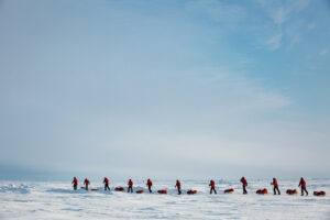
But there are exceptions. Adventure Science’s Footsteps of the Franklin Expedition took a peek at the “rocket,” only to discover it was an ice-filled trench carved out by a grounded iceberg.

“Randall’s Rocket,” actually just an ice-filled trench, is visible as an oblong shape to the right of the red cross. Photo: Randall Osczevski/Google Earth
For all the discouraging setbacks, Osczevski doesn’t seem inclined to find another hobby. And video recently shared with him by explorers Tom Gross and Russ Taichman has re-ignited his interest in Franklin expedition minutia. The pair took the video with an iPhone from a low-flying aircraft, giving Osczevski access to imagery with better resolution than he’s used to.
He sends me snapshots on Facebook Messenger, with red lines pointing to clumps of pixels. He points out round shapes, tantalizing hints of what could be collapsed structures.
I blow the images up on my screen.
I lean in. I squint.