Between the coastal lowlands and arid highlands of Peru lie about 5,200 holes. Carved before the Spanish invasion in 1532, the so-called “Valley of Holes” has long intrigued archaeologists and conspiracy theorists alike. New data suggest the site may have been an elaborate marketplace and, later, an Inca tax depot.
Situated in the Pisco Valley about 200km south of modern-day Lima, the Valley of Holes lies atop Monte Sierpe, or “Serpent Mountain.” The name is not a coincidence. A 1.5km line of round holes snakes across the hilltop, evocative yet eluding obvious purpose. Explanations for the monument have included a grave site, a geoglyph (like the animal shapes at Nazca), an agricultural site, and, recently, a marketplace.

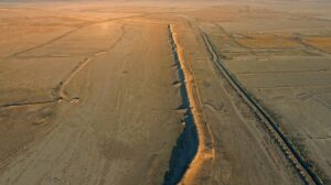
The snake-like line of holes atop Monte Sierpe, seen from above. Photo: Bongers et al 2025
Holes at a crossroads
At the dawn of the first millennium, the Pisco Valley lurked at the edge of the Chincha Kingdom. Although a military society, the Chincha had advanced agricultural techniques. The remnants of their fields lie at the bottom of the foothills, the soil still rich thanks to their use of fertilizers like guano. They fished, too, and sailed the coast.
It was probably the Chincha who first dug the 5,200 holes atop Monte Sierpe. Their kingdom fell to the Inca around 1480, although the Chincha leaders retained much of their autonomy. If the Inca built the Valley of Holes, they had only 60-ish years to do so before the Spanish overthrew them. There are also no similar sites in the Inca heartland.
Monte Sierpe sits in the foothills of the Andes, at the intersection of major trade routes between agricultural plains, fishing coastlines, and mountain mines. Earlier archaeologists suggested that it was ideally positioned as a location for bartering. Now, they have the data to back that up.
Seeds in the ground
The team published their results this week in Antiquity. They surveyed the entire site with high-resolution aerial photography and sampled the soil in 19 holes. They found a variety of seeds and plants not present in the surrounding ground. These included maize, cotton, and brassica. Also present was Humboldt’s willow, a coastal riparian plant used in basket-weaving.
While mountain plants could blow down from higher altitudes, the agricultural products and coastal plants required human transport. The structure of the site also suggests it hosted an activity with many participants. The holes are arranged in clusters of about a dozen rows each, with six or so holes per row.
These clusters could have served as categories in a marketplace, with goods laid out in each hole for easy display. There is enough space between holes to walk through the middle of each cluster, and busier traffic could have crossed between clusters.
Monte Sierpe under the Inca
The Inca did not use money, but their taxation system was rigorous and effective. They recorded census and financial information with a string-based writing system where the placement and type of knots on a string indicated numbers. Different strings combined together into quipus, the equivalent of books.
The authors of the new study suggest that one such quipu, found near Pisco Valley, may describe the Valley of Holes. This quipu recorded large-scale accounting functions, possibly including taxation quotas at the Monte Sierpe site. During the Inca period, it would have been an obvious center of taxation in their strict system.
Right now, the system of writing on quipus retains many mysteries. The exact purpose of this particular quipu is not known. But like many linguistic mysteries, advances in machine learning and encryption may mean answers are closer than ever before.

The study authors suggest this quipu may describe trade or taxation operations at Monte Sierpe during the Inca occupation. Photo: Bongers et al 2025