This summer, Pakistani climbers climbed the elusive 7,708m Tirich Mir for the first time. On August 1 and August 19, two local teams reported summits. Recent accusations sent to several media outlets by an eyewitness have now cast doubt on one of these remarkable achievements. The person claims that the team he was involved with never reached the top.
We contacted both teams for further details and summit proof, with varied results.
First summit reports
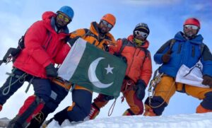
The leader of the first summit team, Abdul Joshi, submitted a press release with details of the climb and shared what they reported as a summit picture, below. Unfortunately, it includes no geographical references.

Summit picture of Tirich Mir provided by the Pakistani Shimshal Guides Expedition
Joshi climbed with a group of guides from Shimshal: Hameed Ullah, Faryad Karim, Mansoor Karim, and Nisar Ahmed. They reportedly summited after a 20-hour push from Camp 3. Joshi wrote in a press release that the team climbed a new route on the west face of the mountain, which he named after himself (the Abdul Joshi route).
From 6,700m upward, the terrain became highly technical, with deep crevasses, steep ice, and dangerous glacier crossings, Joshi wrote. “The most critical part began at 7,450m with exposed rock, followed by a deadly mix of ice and rock at 7,600m.”
At the time of Joshi’s press release, a second Pakistani team, formed by Sirbaz Khan and Abid Baig, reported their later success on social media but had not yet submitted a complete report.
The accusation
Last week, we (among other specialized media) received an email from someone who identified himself as a member of the first expedition team (and asked to remain anonymous while the case was under investigation), reporting “serious concerns regarding Mr. Abdul Joshi’s conduct during our recent expedition to Tirich Mir.”
“Due to deteriorating weather conditions, we were unable to reach the summit and turned back at approximately 7,600m. Abdul asked me to take a photo from below. At that point, Abdul proposed that we falsify our summit success, assuring us of significant financial compensation in return.”
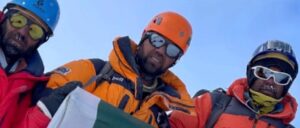
The team member noted that in the end, they did not receive their promised reward. He also explains that a close examination of the reported summit image reveals that the climbers are not on the summit. The climbers’ sunglasses reflect a snowy slope in front of them and the person taking the picture. We’ll come back to this.
Summit picture of Tirich Mir provided by Pakistani Shimshal Guides Expedition
Tirich Mir background
The highest peak of the Hindu Kush, 7,708m Tirich Mir was first climbed by a Norwegian expedition in 1950. In 1967, a Czech team summited via the northwest face from the Tirich Glacier. Nowadays, it’s considered the normal route up the mountain.
Tirich Mir became quite popular among climbers during the 1970s, but Pakistan’s authorities stopped granting permits soon after due to the closure of the nearby Afghanistan border.
There were no summit videos or GPS tracks in that era. The information is often not available online, which adds difficulty to any investigation related to disputed summit claims. 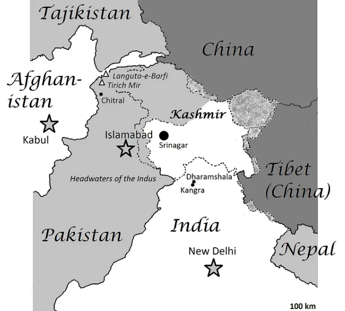
Tirich Mir’s location. Photo: Medium.com
In the 21st century, Tirich Mir has had only two ascents: Jerome Chazelas and Thomas Quillet of France obtained a rare permit in 2016 and summited the main peak via a variation of the 1967 Czech route.
One of the French 2016 climbers above Camp 4 on Tirich Mir, 400m below the summit. Photo: Jerome Chazelas/Thomas Quillet
The second summit in the 2000s was done by Kayuza Hiraide and Kenro Nakajima of Japan, and it was a good one — the first ascent of the previously unexplored north face. ExplorersWeb highlighted it as the best expedition of 2023. It was later awarded a Piolet d’Or — posthumously, since by then, Hiraide and Nakajima had perished on the West Face of K2.

Kazuya Hiraide, left, and Kenro Nakajima on the summit of Tirich Mir. Note the impressive landscape of peaks in the background. Photo: Kazuya Hiraide/Kenro Nakajima
This year, local authorities announced they would waive the climbing royalty fees for Tirich Mir to celebrate the 75th anniversary of the 1950 first ascent. However, a Slovenian team that tried to climb the peak in July was turned away from Base Camp by officials, citing safety reasons. The next climbers to set foot on the mountain were the two Pakistani expeditions.
Sirbaz Khan and Abid Baig’s report
ExplorersWeb checked with Abid Baig and Sirbaz Khan, the two summiters of the second expedition, who reached the top of Tirish Mir on August 19. They provided plenty of summit proof: videos, photos with geographical references, InReach tracking data, and a description of their climb.
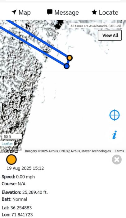
Summit InReach track provided by Abid Baig and Sirbaz Khan
Translated into Google Earth, the coordinates do coincide with the summit of Tirich Mir.
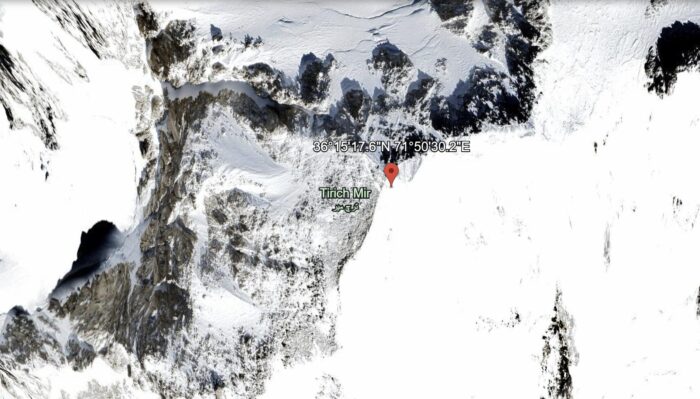
Track’s coordinates on Google Earth.
Sirbaz Khan was Pakistan’s first 14×8,000m summiter, and Abid Baig is also a professional mountaineer who has summited Gasherbrum I, Broad Peak, and Nanga Parbat without supplementary oxygen.
For Sirbaz Khan, this was a very special summit. “It is not only the first all-Pakistani ascent of the mountain, but also part of [my] project to climb the highest peak of the three major ranges of Pakistan: K2 in the Karakoram, Nanga Parbat in the Himalaya, and Tirich Mir in the Hindu Kush.”
‘The ropes were a great help’
Khan and Baig climbed using the ropes previously fixed by Joshi’s team weeks before.
“Some of the ropes were partially buried and covered in frost, so we had to replace them in those sections,” Baig said. “Still, the ropes fixed by Joshi were a great help, as they allowed us to follow the route without having to scout it ourselves. It was a significant assistance, especially for direction keeping.
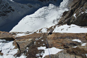
“The ropes ended at approximately 7,550m, [at the exit of a deep couloir] with no indications [footprints, etc.] beyond that point,” Baig said.
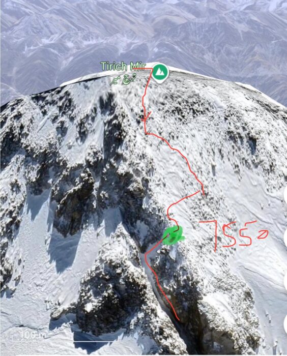
The point where the fixed ropes ended and the route to the summit, marked by Abid Baig.
From that point to the 7,708m summit of Tirich Mir, Khan and Baig needed three more hours.
“Once out of the couloir, the terrain was less steep and not very technical so we didn’t need our ice tools, but the progress was slow and tiring due to deep snow and several boulders,” Baig said.
Baig mentioned that there were other climbers on their team, but only he and Sirbaz Khan reached the top.
Baig also posted details of the climb on his Instagram account:
Tirich Mir’s summit is flat and snowy, as shown in Baig and Khan’s summit video and in photographs of previous summiters, such as the 1967 climbers.
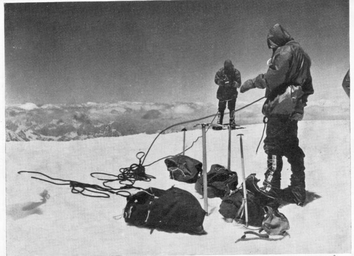
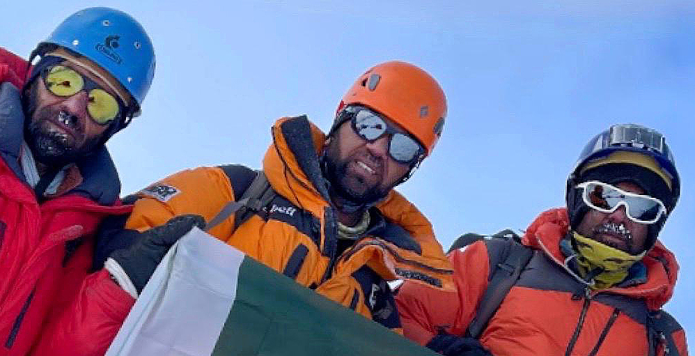
Czech climbers on the summit of Tirich Mir in 1967. Image: The Himalayan Journal
Below, Sirbaz Khan and Abid Baig’s 15-minute video report also includes footage of them on the flattish summit of Tirich Mir:
Variation route?
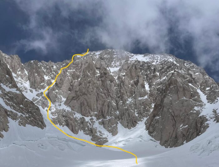
Both expeditions followed the same route up the mountain. At the time, Abdul Joshi claimed it was a new line. However, the data and topos provided tell a different story.
Baig told ExplorersWeb that he had already attempted Tirich Mir the previous year and that they chose their line based on the information available about the 1967 Czech route.
“I already attempted Tirich Mir in September 2024 with Marie Saame of Estonia, which was unfortunately called off due to an accident at Camp 2,” he said. “We studied route options in advance and found this route, opened in 1967, as the most suitable.”
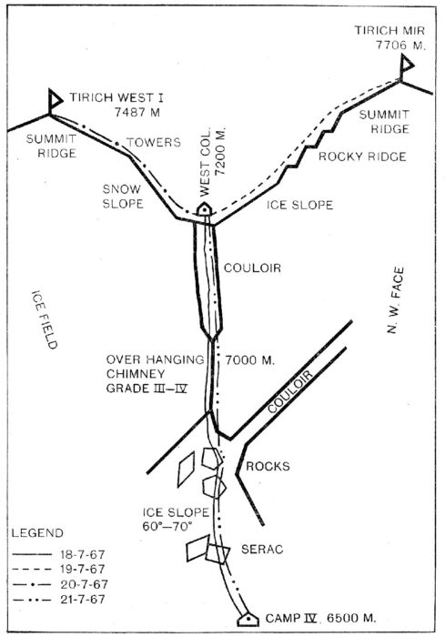
Sketch topo of the Czech route. Image: The Himalayan Journal
The topos provided by the two Pakistani teams show they followed the 1967 Czech route until at least the final section. The Czech route follows a couloir to the west col at 7,200m, while the Pakistani topos show they climbed toward the main summit via the southwest face. Apparently, they followed a different couloir to the summit ridge. In that case, they climbed a variation of the original line.
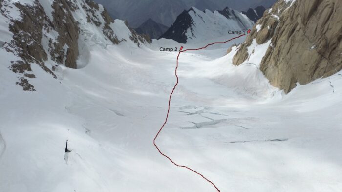
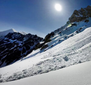
Looking down from the mid-part of the climb to the Upper Tirich Mir Glacier, with camps marked. Photo and topo: Abid Baig
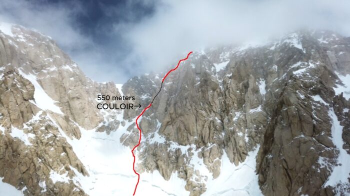
Topo provided by Abid Baig of the upper part of their line, which followed the 1967 Czech route.
The route topo provided by Abdul Joshi, which he said at the time was a new route. Photo: Abdul Joshi
The 2016 French expedition also climbed a variation route of the original Czech line. It looks similar to what the Pakistanis did. Here is what Lindsay Griffin wrote for the American Alpine Journal:
“The crux of the [1967 Czech] route is a couloir above the normal site of Camp 3 (ca. 6,700m). Here, rather than climb the couloir directly, the two moved out left onto snow slopes and climbed more mixed ground to the ridge above. They placed a high camp above the couloir at 7,200m and then took six hours to reach the summit.”
In the UK, the Alpine Journal added a short note to their 2017 report for Central Asia by Hugh Thomas. It indicates the 2016 French variation route went up the southwest face, similar to the Pakistanis. We are currently looking for a complete topo of that French route.
Avoiding controversy
Both Abid Baig and Sirbaz Khan have remarked that they have no opinions about how far the other team got, as they don’t wish to be involved in any controversy. Moreover, they point out the prestigious climbing resumé of Abdul Joshi.
“He is a respected and experienced mountaineer with many notable achievements,” they said. “On Tirich Mir, they fixed ropes up the hardest part of the route, a very steep couloir above Camp 3, which were essential for us.”
Baig suggests that the Alpine Club of Pakistan (ACP) is the proper institution to investigate the climb, if necessary.
Abdul Joshi’s take
Needless to say, we asked Abdul Joshi for his side of the story, details about the summit picture, and further proof, if available. Here is what he said:
We went until Camp 3 without fixing any ropes. Camp 3 was at 6,530m. We started fixing ropes after Camp 3 from 6,700m. It was a couloir with a mix of ice and snow in the beginning and then rock and snow from 7,450m to 7,600m.
Beyond 7,600m, the slope was not as steep. More like a gradual incline with big rock boulders, and the route goes through them. We did not fix ropes beyond 7,600m and climbed just by roping up with each other for safety.
The last part was like a snow dome which we crossed and came on the top. From there, there was nothing left to climb upward. I am positive that we reached the summit.
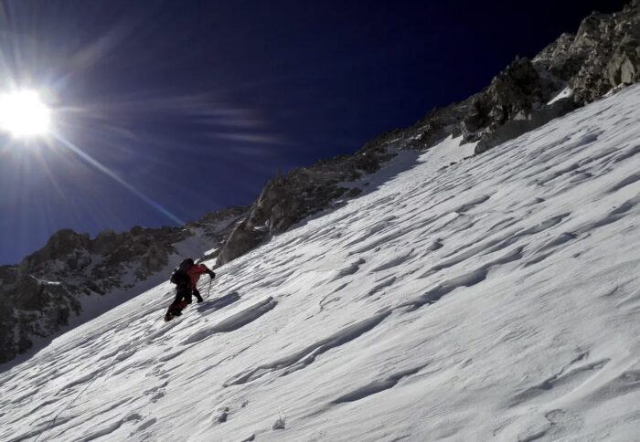
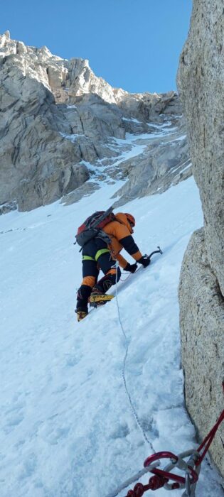
A moment of the climb by the team led by Abdul Joshi. Photo: Shimshal Guides Expedition
As we were fixing ropes ourselves, we got really late in reaching the summit. The visibility was very low. In the summit picture, you see a portion of the sky but all around us, we could not see a lot.
If the experts feel that the usual summit picture spot was a few meters left or right [horizontally], they might be correct, but I am sure that I was at the highest point [vertically] on the mountain. The snow slope ended there, and there was nothing left to climb.
Had we reached earlier with better weather conditions, I might have roamed around on the summit for a better picture and video showing the 360-degree view. But we reached very late. The visibility was really low. The wind was blowing hard. My mobile phone was dead, otherwise I could have taken a screenshot showing the altitude.
I was leading a team of five as the expedition leader. At that time, the safety of all the team members was my biggest concern. So when I was sure that we have reached the top, I did not waste anytime in moving around on the summit. There was only one guy whose phone was working. He took the team picture and we started the descent right away. I am happy that all members reached back safe and sound without any problems.
ExplorersWeb noted the summit picture he provided showed a fairly clear day with no sign of fog or blizzard. Joshi replied that they were not in a total whiteout, but the visibility was still pretty bad.
“Maybe it looks better in the picture,” he said.
Joshi insisted he saw no higher point around them and didn’t take more pictures due to the late hour.
“I did not see any spot where I felt like we should go to take the picture. If the visibility had been better, maybe I would have seen it and would have gone there.”

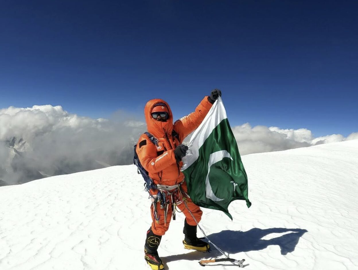
Abdul Joshi of Shimshal. Photo: Kamranonbike
We also mentioned the climbers’ sunglasses seem to reflect a snowy slope in front of them and not the horizon, as one might expect on a flat plateau. Joshi replied that the group in the picture was standing at the top of that slope.
“We came up from that slope, but it ended where we are standing. You can see that it does not continue behind us, as there was not enough space to stand around us on the top; one guy took the picture from the slope.”
However, summit pictures of other climbing teams show a rather roomy summit.
As for the confusion concerning the claim of a new route, Joshi just said he never looked at the history of the mountain to check if someone else had climbed his chosen line before:
I can tell you in detail about the route. How and why i chose it. The exact line. But i don’t know a lot about the history. You can check it for me if it was climbed before or not. What I can tell however is that there was absolutely no signs of anyone or anything. We fixed the ropes and left them there for future expeditions, so my team decided to name the route after me.
Alpine Club of Pakistan
In the end, we can only gather as many facts as possible from the climbers, but it is not up to us to draw conclusions. As Baig suggested, we turned to the Alpine Club of Pakistan and contacted vice-president Karrar Haidr for his comments on the matter. Here is his reply:
At this stage, the Alpine Club of Pakistan has not received any formal or documented claim from Mr. Abdul Joshi confirming a successful summit of Tirich Mir. Consequently, we are not in a position to verify or endorse such reports. As per standard practice, the Alpine Club of Pakistan relies on verifiable evidence and official submissions before recognizing or commenting on summit claims. Should any such documentation be submitted, it will be reviewed accordingly.
Asked about whether he has submitted an expedition report to the ACP, Abdul Joshi said he has not, and he has never done such a thing after any of his climbs.
“Every time, I post the summit picture and share the expedition summary on my social media; same like this time,” he explained.
Joshi added that the officials at the Alpine Club also wrote about his Tirich Mir expedition. He is right; the Alpine Club posted about both Pakistani expeditions on social media in August:
As for Khan and Baig, they told ExplorersWeb they submitted the pertinent documentation, photos, and report, but they have not received a response yet.