Simon-Pierre Goneau and Samuel Lalande-Markon have completed their winter journey from Quebec’s southernmost point along the Chateauguay River to its northernmost point at Cape Anaulirvik near the Inuit community of Ivujivik. The journey — conducted by bicycle and skis — was 2,960km long. It took the pair 68 days of traveling to complete the route.
As previously reported on ExplorersWeb, Goneau completed the cycling portion on a prior expedition. So Lalande-Markon set out on that leg solo, finishing the 1,583km journey along the Billy-Diamond (formerly James Bay) road in 15 days.
In an interview with ExplorersWeb, Lalande-Markon shared that he struggled with isolation and the presence of vehicles during this section, saying that he’d initially “underestimated it a bit.”

Cycling along the Billy-Diamond road. Photo: Marie France L’Ecuyer
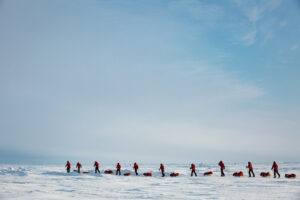
Goneau joined Lalande-Markon in the Cree community of Chisasibi. There, they strapped on skis and towed their 68kg sleds northward. Lalande-Markon noted that Goneau “found the first ski segment difficult, especially because he was embarking on an expedition that was already in motion.”
Other challenges during this portion included deep inland snow and temperatures that never topped -30˚C. The pair identified the section between Chisasibi and Hudson Bay as one of the most difficult slogs of the entire expedition.

Setting out from Chisasibi. Photo: Marie France L’Ecuyer
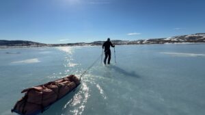
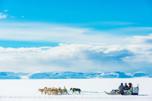
Matters improved when the two skiers reached Hudson Bay and could ski on windblown ice.
“It was kind of a relief,” Lalande-Markon said of reaching the Bay. “After that, it wasn’t exactly a vacation, with ice conditions that were sometimes very fractured, but we were now very confident.”

Skiing near Hudson Bay. Photo: Marie France L’Ecuyer
Goneau and Lalande-Markon skied in segments of six to 11 days, stopping at Indigenous communities along the way to resupply, rest, and visit with local schoolchildren.
The pair reached Cape Anaulirvik on April 28, 2023, in good spirits. They’d made such good time in the expedition’s final quarter that they were forced to slow their pace to allow a documentary crew to catch up with them.
“It allowed us to really enjoy the end of the expedition,” Lalande-Markon told ExplorersWeb.

Near the finish, snow coverage thinned on the land as spring made inroads into the Arctic. Photo: Marie France L’Ecuyer
According to the expedition, the route marks the first time on record that anyone has connected these two points in Quebec while traveling under human power. But the team is always quick to point out that over the thousands of years of Indigenous habitation of the area, someone likely beat them to it. And in any case, they say, the boundaries of Quebec are arbitrary “colonialist structures.”
Expedition of the year and a forthcoming documentary
The thoughtfulness behind the expedition, in addition to the physical and logistical challenges, prompted the Royal Canadian Geographical Society to honor it with its Expedition of the Year award.
On top of that, a three-person documentary crew met up with the expedition on four separate occasions, including at their finish at Cape Anaulirvik. The film, funded by a Canada Council for the Arts grant, is expected to release in the winter of 2024.