Google Earth has done a lot more than show us obscure mountain faces to climb. Zooming in on a Google Earth image has become a tool for archaeologists, historians, and amateur sleuths.
They occasionally find treasure — an old military installation, a long-lost plane crash, mysterious crop circles, and even pop culture accidents, like giant KFC logos in a cornfield.
The Middle East has some particularly puzzling oddities, visible only from above. These man-made structures resembling wheels and kites date back much farther than the Nazca Lines. They were built by an ancient people known as the Old Men.
Background
Although crypto-archaeology isn’t his area of expertise, archaeologist David Kennedy happened to be reading about the Works of the Old Men from the reports of early pilots from the 1920s. He then spent hours on Google Earth assembling over 2,000 images of these structures across the Middle East. But who built them?
The Bedouins themselves refer to mysterious “old men” who built the structures. They say that these have existed long before Islam.
“The old men are what the local Bedouin call the ancient inhabitants of the area,” says Kennedy.
Research confirms that the structures are mostly prehistoric. Some stretch back to the 7th millennium BC. Back then, the Middle East was not the barren landscape we know today. It rained regularly and had lots of grass. This meant humans could settle and graze their animals for long periods.
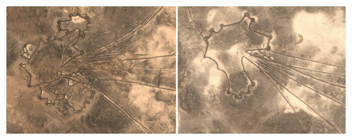
Images of ‘kites.’ Photo: Global Kites/Google Earth
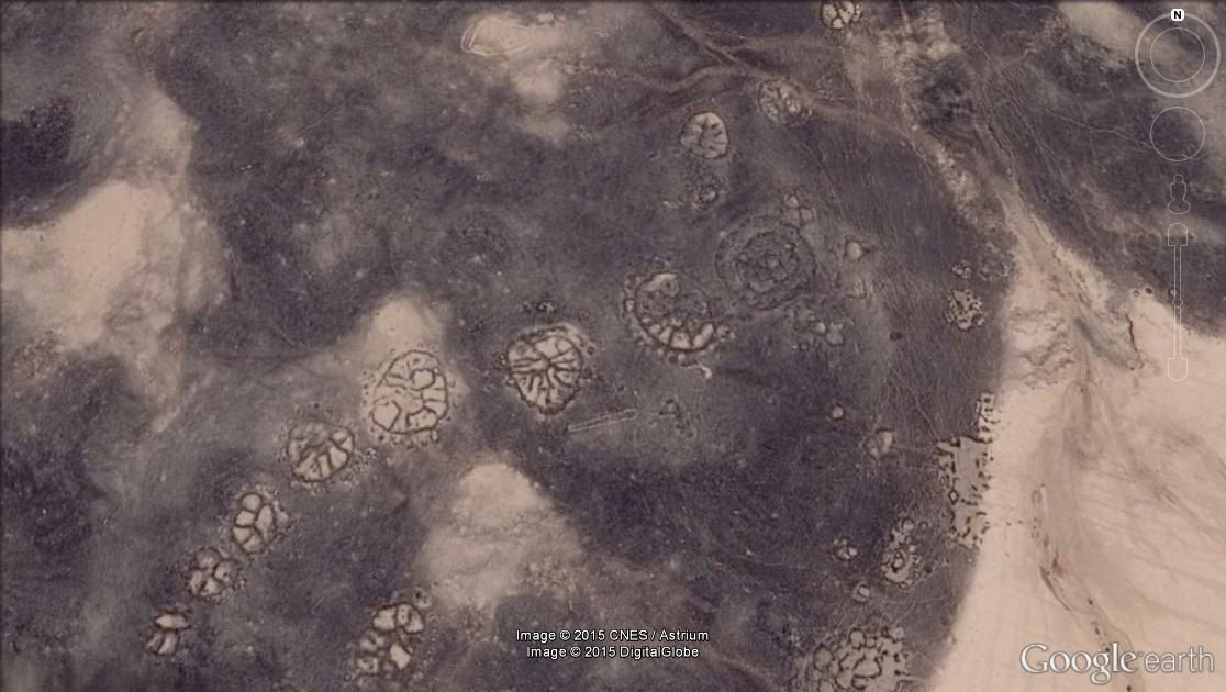
The Works of the Old Men are a series of formations stretching across the Arabian Desert from Syria to Saudi Arabia. They aren’t giant scratches in the ground but are akin to geoglyphs made from stone, in different forms and patterns.
If not for aerial photography, we would never have noticed them. From the ground, they look like a bunch of random rocks. But from the air, they become large, elaborate structures in the shapes of wheels, kites, and gates. In the 1920s, RAF pilots spotted these oddities while flying over the lava-filled desert of the Transjordan Panhandle. It was an accidental discovery: The pilots had simply been scouting a Cairo-Baghdad airmail route.
Most of the works are in this Transjordan Panhandle, in the Harrat ash-Sham — black basaltic lava fields that stretch from Syria to Saudi Arabia.
British archaeologist O.G.S. Crawford wrote in The Geographical Journal in 1929 that, “The walls consist of loose boulders…Their relative weathering proves them to be ancient structures, and they can always be distinguished from modern [Bedouin] work. They know nought of them…”
Characteristics
Usually, they are one to two meters high and up to several kilometers long.
The wheel formation is self-explanatory. It consists of around six spokes radiating from a central point and encompassed by a circular rim. Some have dots inside the wheel; others outside.
Some wheels are not perfect circles. They may be completely irregular, for example, in the shape of a paint splat. The wheels often occur in clusters.
The next common shape is a kite. They are the largest of the works and look like those you flew as a child, with a large, wide head and long tail. Usually, the tails form a funnel that goes into the head.
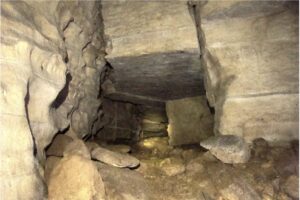
Others are shaped like keyholes, trumpets, pendants, bullseyes, and even circles and rectangles divided into quarters. Some of the structures overlay each other, either to reinforce or repurpose them.
Analysis
Due to the limitations on aerial reconnaissance in the Middle East, there isn’t as much information on the works of old men as we would like.
Sadly, due to political or security concerns, archaeologists and surveyors have to jump through hoops to access these regions or conduct aerial studies. However, Google Earth works outside of the realm of politics. As Australian archaeologist David Thomas said, “Google Earth has a policy of no censorship, so you can get access everywhere.” Luckily, we caught these before they faded into obscurity.
Jordan and recently Saudi Arabia have been very cooperative in allowing researchers to study the shapes with aerial photography and from the ground.
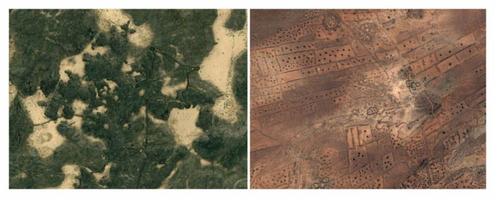
Other Works of the Old Men. Photo: Google Earth
Theories
Some archaeologists have suggested that they are ancient cemeteries or ritual sites. Another popular theory is that the Works of the Old Men had astronomical meaning. Many Neolithic societies put in stone what they knew about the heavens. The placements of the wheels or their spokes could suggest an alignment with the planets or something to do with the solstices. Yet most of these formations do not look like others around the world. They are inconsistent and seemingly too random.
In 2019, archaeologists from the University of Western Australia received permission to study the works in the Harrat Uwayrid in Saudi Arabia. Beneath the structures, they discovered remains of a Neolithic settlement: house remnants, cattle bones, and personal items. This points to the theory that the works were once houses or Neolithic villages.
Other archaeologists think the works, especially the kite-shaped ones, are “mega-traps” for animals. Large herds of gazelle or oryx would roam into the area and go through the narrowing funnel into the head area. Here, hidden hunters would spear or capture the animals for domestication or food.
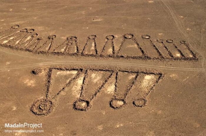
Pendants or keyholes. Photo: Madain Project
Legacy
Finding oddities via Google Earth has become a popular pastime on social media in recent years. Facebook has several hundred Google Earth groups, with Google Earth, Structures and Anomalies banking 1.8 million members. Many members post images of pareidolia, the phenomenon of seeing faces in landscapes. Others also try to find secret locations to prove conspiracy theories.
Some individuals attempt to use Google Earth more actively, like the controversial YouTuber GeoWizard. He walks across countries in straight lines, ignoring the consequences of trespass.
Aerial archaeology has developed as a direct result of Google Earth. It has given us not only a bird’s-eye view but an astronaut’s. It has unlocked a new world, showing us things previously unseen or misinterpreted.
Conclusion
It is safe to say that the Works of the Old Men are remnants of a long-lost Neolithic Arabian past. It was a time when humans built structures for shelter and to trap animals. The variety in the shapes of the works suggests that they weren’t for just one purpose.
Thanks to Google Earth, we will likely uncover many more such mysteries.
