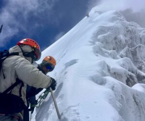
In the Indian Himalaya, the best-known mountains are 8,586m Kangchenjunga, on the border with Nepal, and 7,816m Nanda Devi, the highest peak located entirely in India. But there are many other difficult peaks, with more than 35 higher than 7,000m, and a sea of 6,000’ers. Many of the 6,000’ers are extremely challenging, with interesting climbing stories.
One unique story is the first ascent of 6,794m Mount Gya, one of the most technically demanding peaks in the region.

The location of Mount Gya. Photo: Google Earth
Finding Gya
Gya is located at the head of Chaksachan Lungpa, at the junction of Ladakh, Himachal Pradesh, and Tibet. Gya is considered to be within the Spiti district of Himachal Pradesh, although a major part of the mountain lies inside Ladakh.
Almost hidden by the surrounding mountains, Gya is the second highest peak in Himachal Pradesh after 6,816m Reo Purgyil. From Spiti, it’s a hard approach. Gya sits at the head of a fortress carved out by the cold, fast-running Lingti River. From the Himachal side, the mountain looks like a monolithic 1,200m wall.

Reo Purgyil. Photo: Sumita Roy Dutta
Gya remained unknown to mountaineers until the explorer Harish Kapadia entered the Lingti Valley in 1983. Kapadia described Gya as a virgin, technically challenging mountain, where even the approach was almost impossible. He also took the first photo of Gya.
“With all the high peaks in the Himalaya being climbed often, perhaps the paradigm shift in climbing attitudes will start from here, to climb smaller but challenging mountains,” Kapadia said prophetically.

Gya in the distance, marked with a red dot. Photo: Kiki Mathawan
Different translations
According to a report by mountaineers A.K. Singh and Yousuf Zaheer, Tibetan scholars translated Gya as “vast, great or widespread.” Yet this description doesn’t fit the mountain; Gya is not wide.
Zaheer noted that a minister for the Dalai Lama told them that Gya meant many things, including “hundred,” “white,” or a “long pointed Chinese beard.” Further confusing matters, when Zaheer and Singh visited the Chumar monastery, they learned that local Buddhists call the mountain Khangchan Gyemo or Khangchang Gyalmo. According to legend, a queen and her companions reside there. The Queen’s husband, a neighboring 6,170m peak, had moved away to a lower altitude in anger.
First attempts and confusion
The first attempts to climb Gya were all unsuccessful because of confusion about the location of the real summit, bad weather, and difficulty getting to the base of the mountain.
“[Gya] hides behind the fortress-like ridges of many surrounding peaks and it’s not easily visible from afar. This has resulted in frequent misidentification, leading to many erroneous claims of its ascent,” Zaheer explained.

Badlands in Ladakh. Photo: Reuters-Danish Siddiqui
Writing for The Himalayan Club, Indian climber Motup Chewang Goba noted that between 1987 to 1994, three Indian teams entered the Lingti Valley from the east. They climbed several peaks near the Lingti River. But when they reached the base of Gya, they gave up because of the deep gorges and the high water level.
In 1994 and 1996, a small team from Delhi attempted Gya from the north, approaching from the Rupshu plateau. But Yusuf Zaheer’s team could not summit Gya either year, instead climbing Gya III, also called Gyasumpa.

Gya. Photo: Shailesh Sharma
In July 1995, climbers from the Indian Army’s Dogra Regiment followed the route used by the teams between 1987 and 1994. They claimed to have made the first ascent of Gya, but further analysis indicated that the team confused the summit. They climbed a slightly lower 6,400m peak nearby.
Gya East
In 1996 and 1997, Arun Samant made two attempts on Gya via the east face of the south-southeast spur. He made the first with high-altitude porters Pasang and Prakash Bodh, and Dhanajay Ingalkar, and the second with Chavan and Vinod Bodh.
The April 1997 climb came closest to success. The final crest stopped them before they could reach the main summit. Instead, they turned right to ascend the virgin Gya East (6,680m).
Gya North
In July 1997, Zaheer returned to Gya with Chaman Singh. It was Zaheer’s third attempt. The pair attempted the west pillar. But during the climb, they moved north and eventually ascended by the northeast ridge to make the first ascent of Gya North (6,520m). On July 23, they topped out amid an electric storm.

Gya. Photo: The Tribune
Attempts by larger teams
That same summer, a huge Indian expedition from the South Asian Association for Regional Cooperation (SAARC) set off to climb Gya, led by Col. H.S. Chauhan. The team consisted of 30 mountaineers from the Indian Army and the mountaineering schools of Darjeeling and Manali, including climbers from Nepal, Bangladesh, and Sri Lanka.
They approached from Chumur, via Parang La (5,400m). The party attempted to ascend Gya via two routes simultaneously, the north ridge and the west spur. After their expedition, they claimed to have ascended the mountain’s main peak, putting 32 climbers on the summit.
However, when authorities received the summit photos, it emerged that they had topped out on Gyasumpa (Gya III) rather than Gya.
The next year, in the summer of 1998, another large expedition took place. The Third Infantry Division of the Indian Army, led by Lt. Col. A.B. Goth, also approached from Chumur. However, the team misread the map — confused navigation seems to be a running feature with Gya. Their approach took them 12 days more than expected.
After the expedition, they claimed to have put four climbers on the main summit, but because of a lack of photographic evidence and some suspicious statements by the climbers, their summit was not accepted.
Meanwhile, in late August-September of that same year, the Indian Mountaineering Foundation (IMF) also sent a team to Gya. Under the leadership of A.K. Singh, this team repeated previous mistakes and also ascended Gyasumpa.

A closeup of the unclimbed northwest face of Gya. Photo: Motup Chewang Goba
Failures only made the summit more alluring
“Because of the series of unsuccessful expeditions, it interested me more,” Motup Chewang Goba recalled. “At the time, the elusive Gya seemed to be the goal of most Indian mountaineers.
“Harish [Kapadia] and I used to constantly discuss it. Harish, knowing of my eager desire to get to Gya, kept provoking me. He called me a ‘Delhiwala’, a city dweller, who would love to be in the mountains only in dreams.”

The southeast ridge of Gya. Photo: Motup Chewang Goba via The Himalayan Club
In the late spring of 1999, the IMF organized its second expedition to Gya. Goba led the team, which featured four other climbers and five Sherpas.
They established a base camp at the head of the glacier on May 27 at 4,800m. Four days later, in bad weather, they put up an advanced base camp at 5,350m.
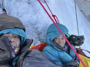
An unexpected rescue
While they worked, they learned of another party on the mountain. A group from Bombay was ahead of them. On May 31, a member of the Bombay team arrived asking for help. Three climbers were in trouble, unable to descend because of bad weather and exhaustion.
A rescue operation kicked off but they could only save two of the three climbers. Arun Samant died during the descent.
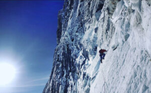
After the rescue, the IMF party established Camp 1 on June 3. They first tried to climb via the southeast ridge, but on June 9 they stopped only 80m short of the top. Huge overhanging rocks formed a giant necklace around the summit. The team had to descend to base camp.
On June 13, they pushed for the summit again, this time by the northeast ridge. They climbed Gyasumpa and started to traverse the slope between Gya North and Gyasumpa on June 15.

The southeast ridge of Gya with climbers on the snowy ridge on the left. Gya North on the right. Photo: Motup Chewang Goba
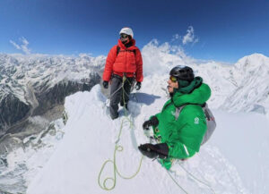
The climb
Unlike on their first summit push, the northeast ridge was too exposed to fix rope. The team split in two, and as the first group climbed, they discovered rope already on their route. Then, as they topped out on the main summit, they found “an old rusted Stubai piton” hammered into the summit rock. One day later, the second group summited too.
Goba’s team brought back proof that the 1998 army team had indeed made the first ascent of Mount Gya.
“[It was] even more satisfying to rightfully justify the army’s ascent of Gya in 1998, which had been considered a false claim,” Goba wrote.

Motup Chewang Goba, President of the Himalayan Club. Photo: Harish Kapadia