Finally, Sherpa members of the Chinese team on Everest have made the summit. While official news focuses on the eight surveyors, who hope to reach the top tomorrow, the six-man vanguard fixing ropes and opening the route have succeeded putting all members on top on a sunny yet windy afternoon.
The first Everest summits this season go to Dorjee Tsering, Tenzing Norbu, Dunpa, Tashi Gombu, Tsering Norbu and Dorjee, according to Mingma G. Check the summit video here.

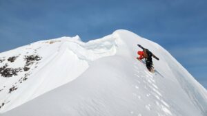
The rope-fixing team heads to Camp 1 on Everest on a previous summit push. Photo: Xinhua
The rope-fixing team had reached 8,600m this morning. After a short rest, they pushed on through the afternoon to the summit.
The meteorologists in Base Camp have confirmed good weather for tomorrow. If so, the surveyors (and their own support team) re-measuring Everest will follow. Mingma G, who is in contact with the expedition outfitter, mentioned a third group: a commercial team projected to reach the top on Thursday.

Views from Camp 2 at 7,890m on Everest North side yesterday. Photo: Xinhua/Zhaxi Cering
Earlier, the surveyors battled gale-force winds from Camp 1 and barely managed to reach Camp 2, according to expedition spokesman Tsering Samdrup. “We spent more than an hour trying to pitch the tents, but failed. Everyone had to hide behind rocks to avoid the gale,” he told the China Daily.
They eventually managed to pitch some tents, but had a rough night holding them down from the inside with their hands, as the poles threatened to bend and break under the force of the gale. They also had to protect their sensitive measuring equipment. This suggests that the summit team faced similar — if not even harsher — conditions. Nevertheless, the surveyors left Camp 2 at 7,790m earlier today and reached the highest camp at 8,300m.

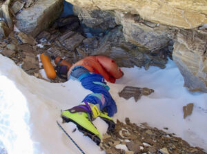
A wind-battered tent at Camp 2 on Everest this morning. Photo: Xinhua/Zhaxi Cering
Everest’s growing pains
Chinese surveyors have measured Everest twice before, in 1975 and 2005. The altitudes then were 8,848.13 meters and 8,844.43 meters, respectively.
As the Eurasian and Indian-Australian tectonic plates that formed the Himalaya are still moving, Everest’s altitude continues to change relatively quickly. The measurement from 1975 is consistent with the overall accepted altitude of 8,848 meters (29,029ft), as stated in the 1954 Indian survey. A 1999 American expedition came away with a result of 8,850m, but it was not widely accepted.
Differences among measurements may be influenced by the variable thickness of the snow cover on the top: China’s 2005 measurement, for instance, did not include the mountain’s snowcap, thus the lower result. That conclusion brought a bitter controversy with neighboring Nepal. In fact, in 2019, Nepal purportedly led a measuring expedition of its own to measure the mountain with and without snow. Team leader Khim Lal Gautam and climber Rabin Karki reached the top on May 22 and reportedly conducted some measurements, but no results have been released.
The current expedition is using China’s network of Beidou satellites instead of the “western” GPS system. It will be interesting to see whether the 2015 earthquake changed the peak’s height, as some experts suggest it may have.