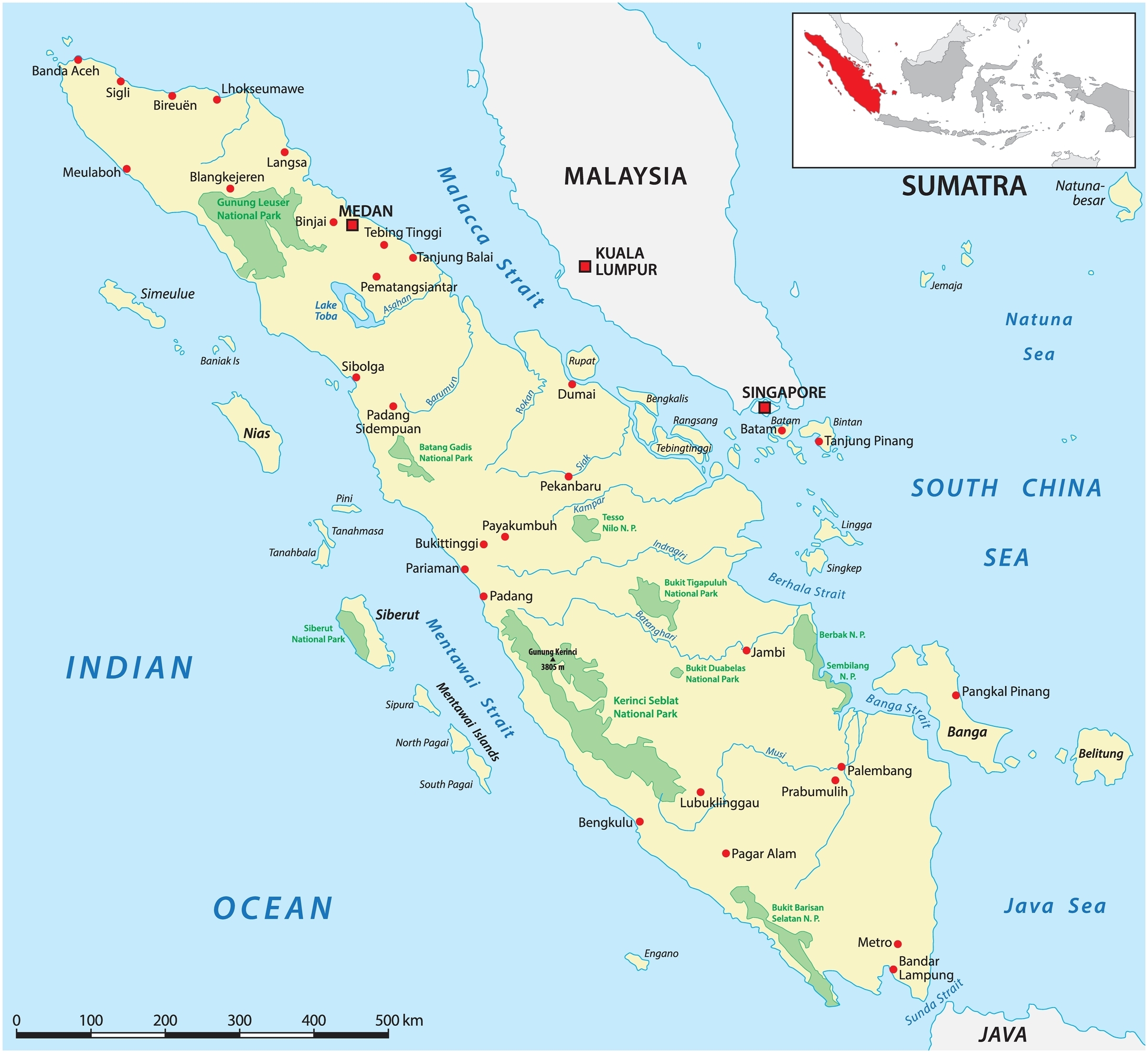
In this series, we consider the 10 largest islands in the world from the perspective of an adventurous traveler looking for new possibilities.
Since there are no new continents to discover and a growing shortage of unclimbed mountains, modern adventurers often focus on lists. Projects involving or linking the 10 largest islands in the world are a great start.
Today, #6: Sumatra
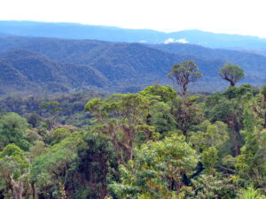
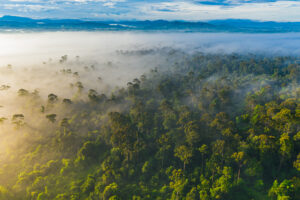
Known today as Sumatra, people have been living on Indonesia’s largest island for 70,000 years. Life on Sumatra has changed considerably since that Paleolithic era, but the modern cities of today still share the island with vast swaths of wild jungle.
Over one third of Sumatra’s 470,000 square kilometers is virgin rainforest. In 2004, 25,000 square kilometers of the island were declared a UNESCO World Heritage Site, forming one of the largest protected areas in Southeast Asia. Though not without its difficulties and dangers, the island is rich in opportunity for self-propelled travelers.
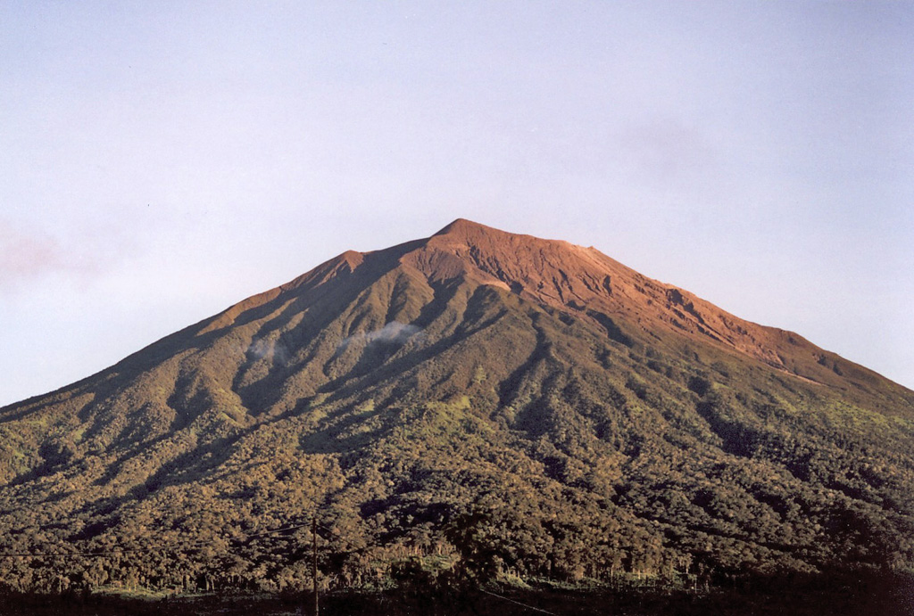
Sumatra is a long, slim island marked by half a dozen parallel rivers and the large ring of Lake Toba. Photo: Shutterstock
Historical primer
Archaeologists date the remains of our extinct relatives, Homo Erectus, in Indonesia to over 700,000 years ago, when the islands were part of a single landmass. The first modern humans showed up 70,000 years ago, on their way from Africa to Australia.
Most groups in Sumatra today descend from successive waves of talented seafarers who set out from Taiwan. They eventually settled a significant chunk of the globe, from Madagascar to Rapa Nui. By the early Middle Ages, Sumatra was the center of a powerful maritime empire and classical Buddhist kingdom.
Eventually, the Buddhist empire’s power waned, but the Muslim merchants who came in their place brought the spice trade as well as their religion. Soon, Sumatra had a booming pepper business.
Sensing a spice opportunity, the Dutch were quick to come calling and did not relinquish control of the island until after World War II. In 1949, Sumatra became part of the new independent nation of Indonesia.
View from the Dutch Fort de Kock in West Sumatra, circa 1900. Photo: Leiden University
Exploration and Sumatra
Its location along major trade and migration routes gave Sumatra a long history of exploration. Italian explorers like Marco Polo brought elusive rumors of the vast island back to Europe in the 13th century, but the first modern expeditions came from the spice-hungry Dutch.
One interesting account comes from Thomas Dias, a Dutch East India Company middle manager desperate to restore his good name through daring acts of entrepreneurial colonialism after a political falling out. In 1684, he embarked on an ambitious journey into the Western Sumatran kingdom of Pagaruyung to forge trade relations with the Minangkabau people.
Dias’ expedition successfully made the dangerous journey across the island and up the Kampar Kiri River. His records include a rare and valuable account of the 17th-century Minangkabau court, which they were the first Europeans to visit.
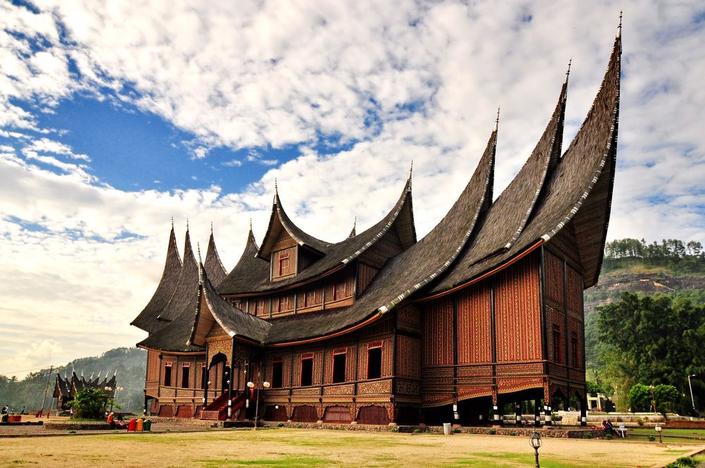
Modern replica of the 17th-century Pagaruyung Palace that Dias visited. Photo: Public domain
Volcanic mountaineering
Sumatra has experienced almost 200 volcanic eruptions since the 16th century, with over 100 active volcanoes. Just offshore, the infamous Krakatoa eruption, one of the most powerful in recorded history, occurred in 1884. The highest point on the island proper is Mount Kerinci, a 3,800m active volcano.
In December of 1877, Daniel David Veth and Arend Ludolf van Hasselt led an expedition up the mountain, alongside their chef, 16 hired local men, a cook for the local men, a regional leader named Tara, his two followers, and two trail-breaking scouts. This large party easily made its way up the foothills. As they pressed on, however, heavy rains made the slopes unstable. They had to break their own trail, slowing progress to a crawl.
Leaving most of the party behind, the two Dutchmen made a final push for the summit. Veth describes a grueling march, hacking through vegetation and getting turned around on meandering goat trails. The final push was, and remains, a scramble up loose scree. Finally, they arrived on the summit rim of Kerinci, marking the first recorded summit.
Today, summiting Kerinci is more of a strenuous hike than a mountaineering challenge. At the top, after several days of trekking, you can see the blue crater lake and sweeping views of Kerinci valley. It can be climbed in one day, with a Fastest Known Time of 2h 13m 57s, set by Eamonn Schnell in 2025, but most spend a night on one of two mountainside shelters.
Mount Kerinci overlooks tea plantations on one side and a national park on the other. Photo: D. Rochendi/Smithsonian
Volcanic circumnavigation
Volcanoes also present unique opportunities for new challenges. In 2013, adventure runner Richard Bowles went on an expedition to Sumatra because, as he put it with refreshing honesty in a frankly unhinged magazine interview, “a backpack company paid me to.” Mercenary or not, he put his all into it, running 800km from the eastern to western regions of Sumatra.
As he pushed on toward Mount Sinabung, it began erupting, and many evacuated the area. Bowles kept running, dodging debris and ash clouds, and became the first recorded person to, ahem, circumnavigate an actively erupting volcano.
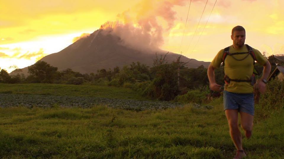
Bowles runs from the erupting volcano. Photo: Facebook
Trekking in Sumatra
Mike Horn, one of Explorersweb’s 100 Great Explorers of the Last 100 years, crossed the island on foot during his 1999-2000 circumnavigation of the globe. It took him two-and-a-half months to trek across Sumatra and Borneo, following the equator across the island. The equator line runs the short way through; no one has yet tested themselves on foot against Sumatra’s 1,790 km vertical axis.
Most of the few serious ventures into Sumatra’s jungle come from conservationists and scientists. Last year, an expedition led by biologist Chris Thorogood located an extremely rare Rafflesia hasseltii flower after weeks of jungle trekking. The world’s largest flower, it emits a rotting-corpse stench and is so rare that team member Septian Andrikithat fell to his knees and sobbed at the culmination of his 13-year quest to find it.
The recreational draw of Sumatran trekking is the wildlife, like the Sumatran orangutan, elephant, rhinoceros, and tiger. While tiger attacks are a real danger in parts of the world, only 700 or so Sumatran tigers remain in the wild, so they are an unlikely threat. The real wildlife to worry about is mosquitoes.
As in much of the tropics, deadly mosquito-borne illnesses are endemic to Sumatra, most notably malaria and dengue fever. Malaria is one of the deadliest diseases in both the human past and human present, while dengue can be so agonizing that it’s known as “bone-break fever.”
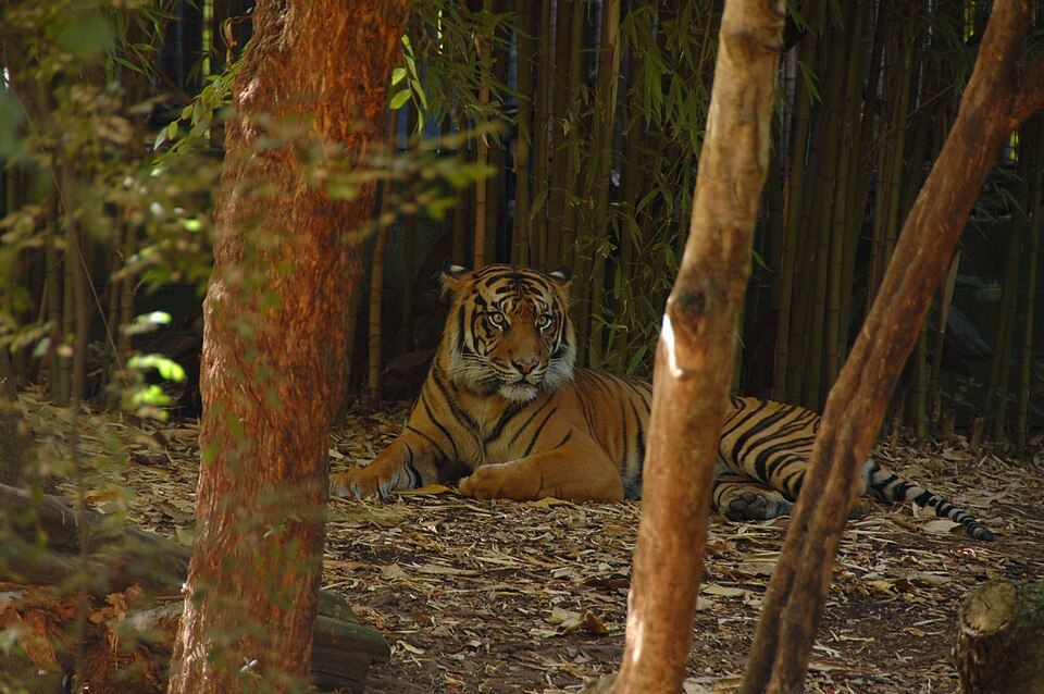
The Sumatran Tiger is the smallest species of tiger, an example of island dwarfism. They’re about half the size of the Amur or Siberian tiger. Photo: Wikimedia Commons
Grave of a supervolcano
The northern part of the island is home to Lake Toba, the watery caldera of the Toba supervolcano. It erupted 74,000 years ago, in what was the biggest eruption in the last 28 million years. For decades, it was theorized that the Toba eruption nearly wiped out humanity, causing the population bottleneck that our comparatively low genetic diversity suggests. Modern science casts doubt on the theory, but still believes the eruption had a massive impact worldwide.
Today, the site of this massive destruction is a scenic lake ringing the island of Samosir. In 2013, it hosted the World Super Swim during the annual Lake Toba festival. The four-person relay took place over several days, with the winning team completing a 118km circumnavigation of the island in under 24 hours.
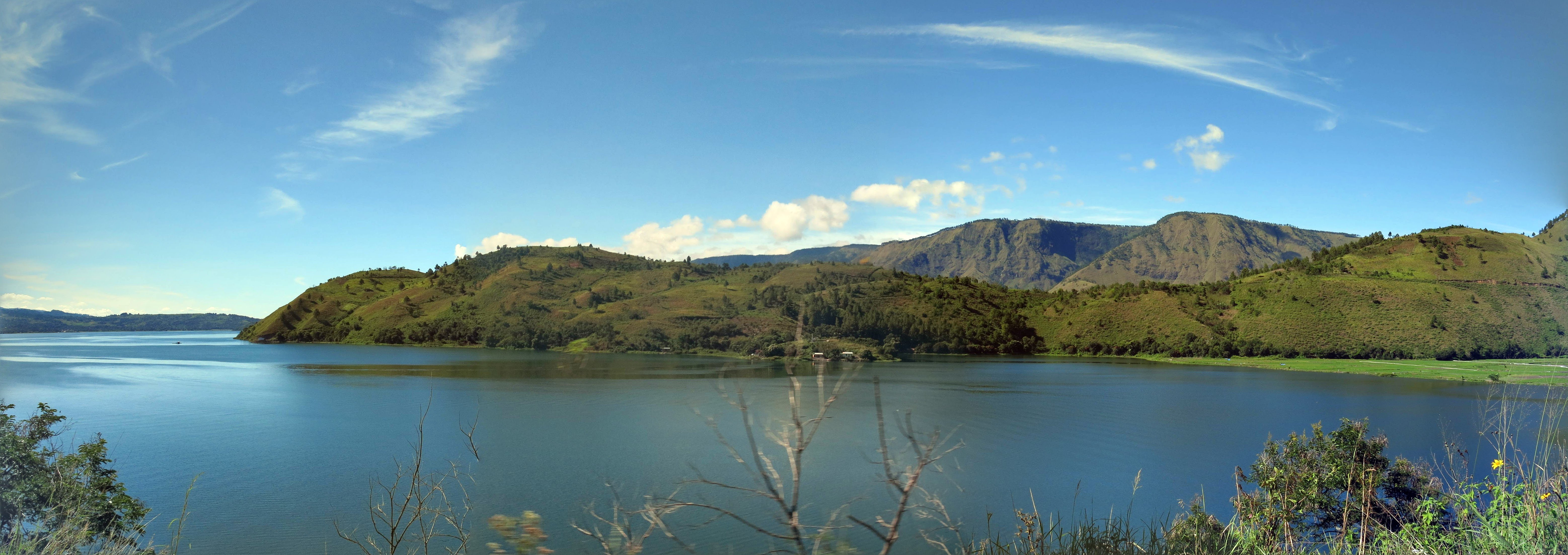
Lake Toba. Photo: Wikimedia Commons
Sumatran rivers and rafting
Over a dozen major rivers cross Sumatra. Outside of the sections of Sumatran rivers paddled by guided tour groups, small expeditions are still snagging first descents. The Alas River, which flows through an orangutan preserve, was the destination of a 1986 expedition led and documented by explorer and pioneer adventure tour outfitter Richard Bangs. The expedition successfully completed the first descent of the Alas.
Paddling and rafting as a sport in Sumatra is relatively new. Outfitters began to spring up in the years following Bangs’ expedition, like the one founded by Georg Jackstadt, who rafted and paddled in Sumatra since the 1990s, exploring and making first descents on the waterways. He has now passed, but decades of Sumatran kayaking expeditions were launched under his auspices.
Like other independent outdoor adventures, paddling is complicated by inaccessibility and marginal infrastructure in rural areas. Outside the cities and tourist destinations, many people don’t speak English, although they do speak at least one of over 52 other languages, including Chinese, Tamil, and regional Malay variants. Most speak Indonesian as a first or second language.
Just getting anywhere outside of major tourist areas can be complicated, as paddlers David Silk, Seth Ashworth, and Ben Sandeman discovered on their 2020 whitewater kayak expedition. Despite illness and logistics, they still managed several first descents on unpaddled watercourses west of Lake Toba. The same year, professional kayaker Galen Volckhausen completed a first descent of the 21m Katasa waterfall.
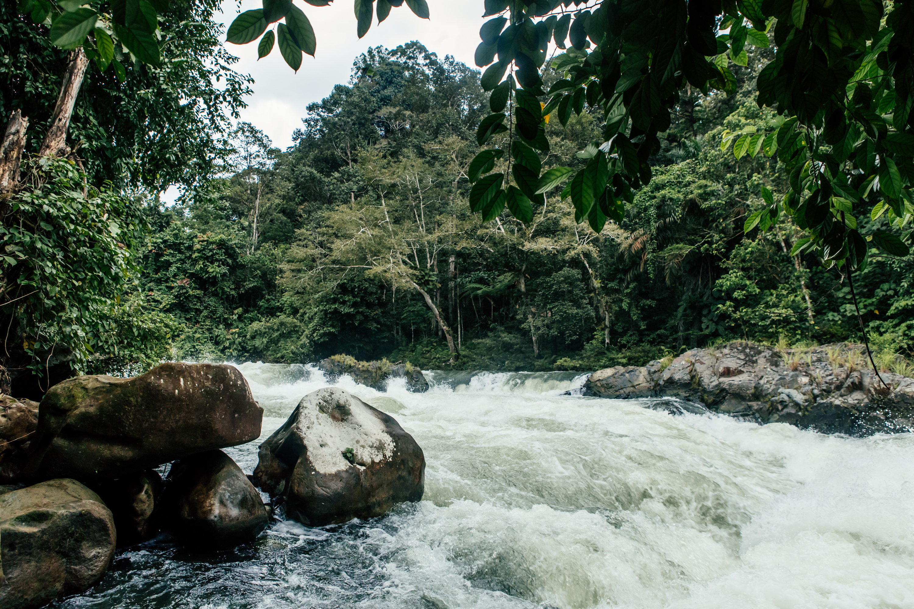
Whitewater rapids on the Asahan River. Photo: Shutterstock
Paddling around Sumatra
One of the most ambitious Sumatran paddling projects takes us from the rivers to the sea itself. In 2011, two Dutch paddlers, Robert Versprui and Joost Bienenmann, set out to circumnavigate the entire island by sea kayak. During the journey, they aimed to be self-sustaining by wild camping and catching their own food.
The 4,250km route took them five months, a month longer than planned. In fact, as they admit in a post on their now-defunct blog, they overstayed their visas just to complete the trip. Luckily, they were never stopped, and they finally kayaked up to the same pier they had departed from.
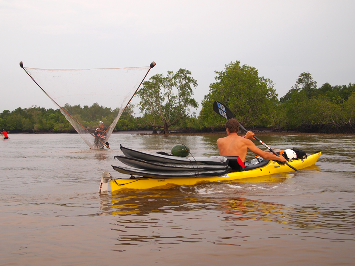
Robert Versprui and Joost Bienenmann kayak around Sumatra. Photo: Sumatra Challenge (Archived)
Climbing and adventuring
Sumatran climbing is also still developing, with neighboring Java garnering more attention from climbers. But the island is rife with dramatic cliffs and rugged spires, like in West Sumatra’s Harau Valley. Only a few hours by car from Padang airport, the Harau Valley features 80 to 300m tall rock walls and dozens of routes.
Other developing climbing opportunities include the Andaleh crag in the western highlands and coastal limestone crags in Aceh, up north. It should be noted that the Aceh region, in particular, is less politically stable than the rest of Sumatra, and laws regarding dress and behavior are stricter than elsewhere.
The Harau Valley has developed routes from grades 4c+ to 8c+, as well as potential for developing future routes. Photo: The Crag
While it’s been the site of several ambitious projects and expeditions, adventure hounds sniffing out firsts have yet to exhaust the possibilities of Sumatra. But they may not have much time left to explore the island. Palm oil plantations and illegal logging have destroyed nearly half of Sumatra’s forests in the past two decades.
Irresponsible, unethical tourism can be ecologically devastating. However, when done responsibly, a growing tourism industry can provide alternatives to an economy based on environmental exploitation. It’s an approach which has worked in nearby Komodo, and may, we hope, become part of saving Sumatra.
Previous stories in this series: