In this series, we consider the 10 largest islands in the world from the perspective of an adventurous traveler looking for new possibilities.
Since there are no new continents to discover and a growing shortage of unclimbed mountains, modern adventurers often focus on lists. Projects involving or linking the 10 largest islands in the world are a great start.
Today, #9: Great Britain.
Although you could fit Great Britain into the state of Texas nearly three times over, this island, consisting of England, Wales, and Scotland, has always packed a punch, both in global affairs and in adventure and exploration.
The highest peaks may only just tip over 1,000m, and the mercury rarely drops much below zero, but the nation has given birth to many pioneering travelers and adventurers, from the 20th-century desert explorer Wilfred Thesiger to legendary mountaineers Chris Bonington and Doug Scott.
A rock-climbing mecca
There is a wealth of high-quality traditional climbing and sport climbing around Britain to keep the keen adventure climber happy. There’s too much to highlight them all, but one particular area is undoubtedly a mecca for trad climbers. The Peak District, which was the UK’s first national park from 1951, holds some of the finest gritstone climbing in Europe. Although the routes are short, typically 5-20m, they are often bold, creative, and of high quality.
The most well-known crag is Stanage Edge, which stretches for around five kilometers and features over 2,000 routes. In 2021, Richard Taylor climbed 616 routes on Stanage in a day, and there are many similar challenges for experienced climbers, such as 100 solos in a day or completing all 29 starred E1 (5.10) graded routes.

Stanage Edge panorama, a gritstone ledge in the Peak District, Derbyshire. Photo: Shutterstock

Photo: UK Climbing
From hard to extreme
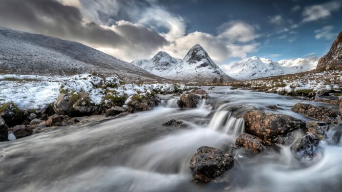
For mountaineers, Snowdonia in North Wales, the Cairngorms, Glen Coe, and Ben Nevis (the UK’s highest peak at 1,345m) in Scotland, are standout locations. But the real test piece for alpinists is the Cuillin Ridge on the Isle of Skye, which sits just off the west coast of Scotland.
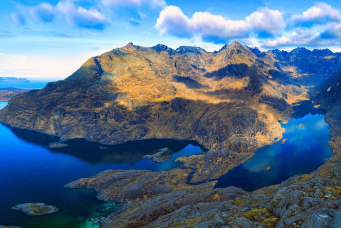
View from Sgurr Na Stri over Loch Coruisk to the rugged peaks of the Black Cuillin Hills, Isle Of Skye, Scotland. Photo: Shutterstock
Cuillin Ridge
A complete traverse of the Cuillin Ridge is the most demanding and rewarding mountaineering undertaking in Britain. The 12km route packs in around 3,000m of cumulative ascent and descent, linking 10 or 11 Munros (see below) and 30 summits in all, depending on the line taken.
It requires hillwalking, exposed scrambling, and rock climbing skills. Although three of the technical sections can be bypassed, most parties will still require a rope, particularly for the rappel from the Inaccessible Pinnacle.
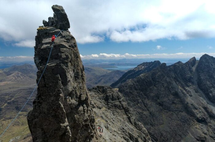
Rappelling the Inaccessible Pinnacle. Photo: Walkhighlands.co.uk
Completing the ridge can take anything from a fast five-hour push to multiple days, depending on conditions, experience, and strategy. Many teams choose to bivouac on the ridge. Careful preparation is essential, as there is very little water on the ridge, and escaping the ridge is often difficult. In winter, timing becomes even more critical. A stable weather window following snowfall and a subsequent hard freeze is key.
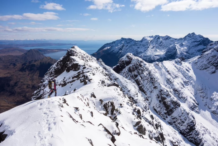
Approaching Sgurr na Bhairnich on the Cuillin Ridge in winter. Photo: masterplan-mountaineering.co.uk
Peakbagging
No other country does mountain lists like Britain. The best known are the Munros, Scotland’s 282 mountains over 3,000 feet (914m), first dreamed up (but not completed by) by Sir Hugh Munro of the Scottish Mountaineering Club in 1891. Alongside them sit the Munro Tops: Scottish summits over 3,000 feet that are considered subsidiary tops of a Munro rather than separate mountains. Completing the Munros is a lifetime goal for hillwalkers in Britain, with 8,267 recorded Munro completions to date.
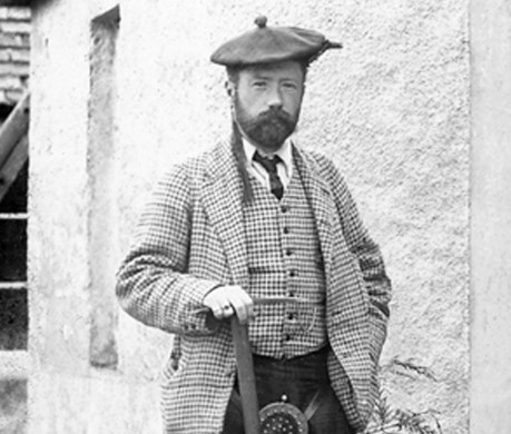
Sir Hugh Munro. His catalogue of mountains exceeding 3,000 feet was first published in 1891, appearing in the sixth issue of the Scottish Mountaineering Club Journal
In September 2025, Hazel Strachan completed her 13th round of the Munros, a female record. Steve Fallon has completed a whopping 16 rounds. Only four mountaineers have completed a Munro round in a single winter, as the Scottish mountains in winter are notoriously harsh. The first winter completer was the late mountain guide Martin Moran in 1985.
Buachaille Etive Mor in Glencoe, one of the most striking Munros. Photo: Shutterstock
Below the Munros lie Scotland’s quieter lists. Corbetts rise between 2,500 and 2,999 feet. (Everyone uses feet in the context of these peaks.) The Grahams cover hills from 2,000 to 2,499 feet, extending peakbaggers’ exploration into islands, peninsulas, and broad uplands. Further south, the 214 Wainwrights of the Lake District in England exist because famed guidebook author Alfred Wainwright chose to draw and describe them.
The Nuttalls catalog every summit over 2,000 feet in England and Wales with at least 15 meters of drop, while the Marilyns span the whole of Britain and Ireland, defining any hill with 150m of prominence.
Scafell Pike, a Wainwright top, is England’s highest mountain at 3,209 feet. Photo: Shutterstock
For those fit enough, outdoor writer Will Renwick ran all 189 mountains (over 600m) in Wales in 23 days, covering 800km.
Long-distance hiking
There is no shortage of long‑distance trails suited to thru‑hiking, ranging from gentle pastoral routes to more demanding mountain hikes. The classic Land’s End to John o’ Groats hike (1,956km) runs the length of mainland Great Britain, from Cornwall’s southwestern tip to the far northeast of the Scottish Highlands. However, this often involves road walking, unless carefully planned, and is a common target.
The longest thru-hike on trails is the newly designated King Charles III England Coast Path, announced in March. While sections are still being completed, the vision is ambitious: Once finished, the route will form the world’s longest managed coastal path.
Encircling the entire English coastline, the trail will extend for approximately 4,350km. Beyond the path itself, walkers will also gain access to adjacent beaches and coastline.
The King Charles III England Coast Path. The missing section on the left-hand side is the Welsh coastline. Map: nationaltrail.co.uk
In 2020, before the launch of the King Charles III Coast Path, British photographer Quintin Lake completed a (non-continuous) walk around the coast of Britain. It took five years and covered 10,000km. In 2023, Emma Schroder completed a 6,100km variant of the coastline of Britain, over a two-year period.
Cape Wrath Trail
Arguably, the most demanding long‑distance route in Great Britain is Scotland’s Cape Wrath Trail. The trail lies in the far northwest, running through the Scottish Highlands. Beginning in Fort William, at the foot of Britain’s highest mountain, Ben Nevis, the route finishes at Cape Wrath, a remote headland on the Atlantic coast that marks the northwestern tip of mainland Britain.
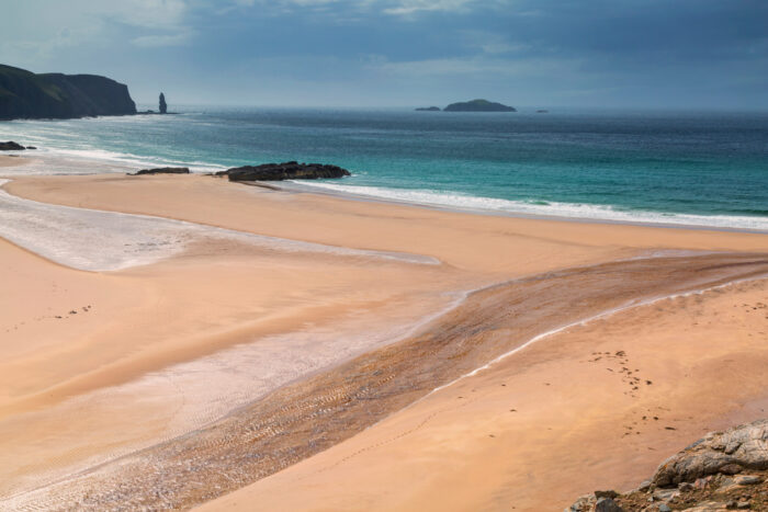
Sandwood Bay, near the finish of the Cape Wrath trail. Photo: Shutterstock
The trail covers roughly 330 to 350km and crosses some of the most isolated terrain in the country, including Knoydart, Torridon, Assynt, and Sutherland. The route is unofficial and unmarked, and there is no fixed route. The Cape Wrath Trail is usually hiked in late spring and summer. It can also be done in winter, although snow cover, short days, and avalanche conditions significantly increase the seriousness.
On the Cape Wrath Trail. Photo: Shutterstock
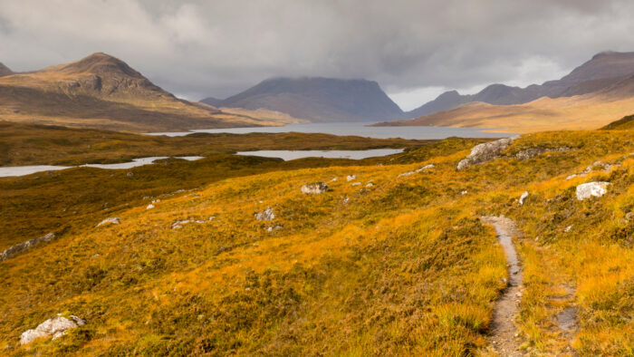
The route repeatedly traverses rough mountain terrain, passing striking peaks such as Suilven, with frequent steep ascents and rough ground. Typically taking two to three weeks in summer, the journey involves long sections between resupply, boggy ground, and rapidly changing Atlantic weather.
Last month, David Parrish, 35, died while trying to set a Fastest Known Time on the route, highlighting the seriousness of the trail even in the gentler seasons. There are multiple variants of the fastest time on the trail, all by runners, taking between 3 and 5 days depending on the route followed.
The shores of Loch Veyatie, with Suilven looming in the background. Photo: Ash Routen
Aside from official routes, there are many other long-distance hiking challenges. For example, Chris Townsend’s 2013 Watershed Walk follows Scotland’s drainage divide for roughly 1,200km, tracing the line between rivers flowing west to the Atlantic and east to the North Sea, from the English border to Duncansby Head in the far northeast of mainland Scotland. Townsend is globally recognized as one of the most experienced and prolific long-distance hikers.
Paddling adventures
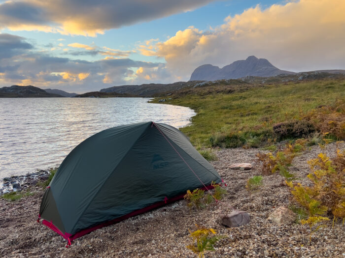
There are numerous rivers across the three nations that offer whitewater kayaking, particularly in the mountains of Wales and Scotland. For canoeists and packrafters, the northwest of Scotland, particularly the Assynt region, provides a high proportion of inland and sea lochs that can be interlinked for multi-day packrafting expeditions.
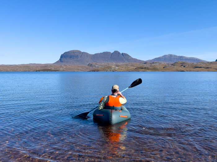
Packrafting on Loch Sionascaig with the ridgeline of Suilven in the background. Photo: Ash Routen
Nick Ray’s 2022-3 kayak route. Map: Nick Ray
Marathon paddleboarding
For longer routes, Cal Major stand-up paddleboarded along the west coast and inland from Land’s End to John O’Groats in 59 days, covering 1,600km in 2018. Meanwhile, fewer than 20 solo paddlers are thought to have completed a full kayak circumnavigation of Great Britain. In July 2025, Polish athlete Sebastian Szubski finished a solo lap of the coastline, covering 3,000km in 37 days. His time was three days faster than that of Dougal Glashier, who set the previous benchmark in 2023.
Glashier’s route was reportedly slightly longer, at around 3,120km, and both journeys involved support crews. Before Glashier, the record was held by Joe Leach, who completed the circumnavigation in 67 days in 2012.
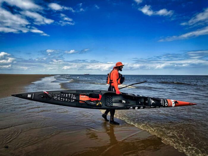
Photo: Sebastian Szubski
In 2025, Jim Mee kayaked laterally across the British Isles, from the east coast of England to the west coast of Ireland, 1,000km away, following canals, rivers, and coastline.
In 2021, Brendon Prince completed a stand‑up paddleboard circumnavigation of Britain, taking 141 days. He paddled a total of 4,203km, becoming the first person to paddleboard around Britain. A more sedate option is to paddle the English canal system from the Lake District to London, which has been completed by one Briton over a 10-day period.
Open-water swimming
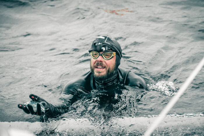
Open‑water swimmers have a wide range of long‑distance challenges to choose from, but the most iconic is the English Channel crossing. Reserved for the most experienced, the swim covers 32km between the south coast of England and northern France, typically from Dover to Calais. There have been 2,050 solo completers since 1875, with 75 of those in 2025.
Swimmers must contend with cold water, strong tidal currents, heavy shipping traffic, and long hours of continuous effort, often pushing total swim times far beyond the direct distance. You’ll need an officially registered Pilot and Escort boat, though, which typically costs $4,000 or more.
Ross Edgley treads water during his record-setting swims around Britain. Photo: Harvey Gibson/Red Bull
For those seeking something even more committing, British endurance swimmer Ross Edgley completed a full circumnavigation of mainland Britain in 2018. The 2,882km swim took 157 days, and the Briton slept and ate on a support boat. Edgley is the only person to have achieved the feat.
At the opposite end of the spectrum, Britain also offers far more accessible open‑water swims in the Lake District of Northern England. Sixteen major lakes are regularly used by swimmers, with the longest being Lake Windermere, where a lengthwise crossing measures around 17km and provides a comparatively controlled environment: Most swimmers are expected to wear a triathlon suit and tow a float bag. Earlier, hardier generations raced Windermere’s frigid waters in just their swimsuits.
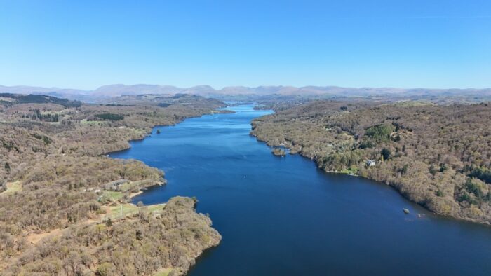
Lake Windermere, Lake District, England. Photo: Shutterstock
Esoteric pursuits
For those looking for something more unconventional, some of the UK’s most exposed coastal features offer climbing of a very different character. Few routes better illustrate this than Skeleton Ridge on the chalk spires of The Needles, off the Isle of Wight on England’s south coast. Rising directly from the sea, the route follows a narrow arete for nearly 200m back to the clifftop and is rarely climbed.
Skeleton Ridge is notorious for poor rock, limited opportunities for placing protection, and huge exposure. Conditions and the exact line change continually with erosion, but the ascent typically begins with a wade at low tide to reach the gap between the first and second pinnacles. What it lacks in technical difficulty, it more than makes up for in commitment and seriousness.
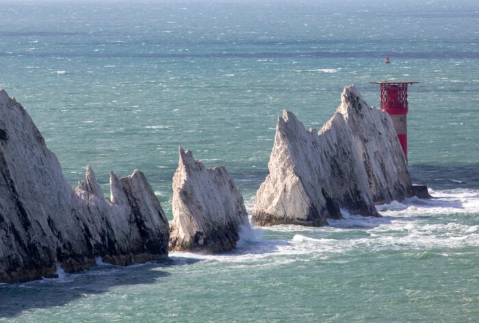
The aptly named Needles at the Western tip of the Isle of Wight in choppy seas. Photo: Shutterstock
A longer and more committing counterpart is the Exmoor Coast Traverse on the North Devon coastline. Covering around 23km, the sea-level route combines extended sections of scrambling and climbing (roughly a third of the distance) with sustained stretches of boulder‑hopping and awkward rock steps.
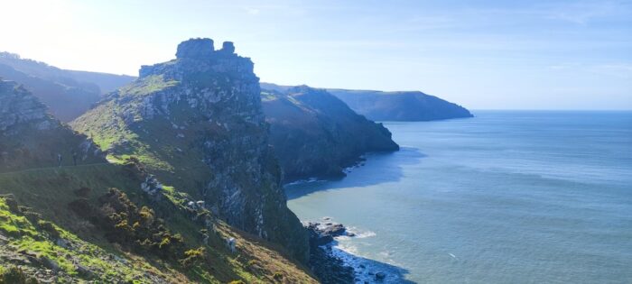
The rugged Exmoor coastline. Photo: Shutterstock
Likened to a low‑level alpine traverse, the outing threads beneath huge sea cliffs and demands careful judgment around tides and limited escape options. Its length, complex terrain, and committing nature mean it’s rarely attempted, despite lying within a well‑known national park.
Previous story in this series: