For nearly half a century, a single photograph defined one of the Karakoram’s most striking peaks. Taken in 1909 and reproduced in books and journals, it showed Muztagh Tower as a vertical blade, a slender tooth of rock and ice rising from the glaciers with no obvious weakness. Generations of climbers studied it and concluded that the mountain was impossible to summit.
In the summer of 1956, two independent expeditions arrived on opposite sides of the peak, each convinced they were looking at one of the range’s last great unclimbed problems. But the photograph had misled them.
The photographer
Vittorio Sella was born in 1859 in Biella, Italy, into a family connected to the mountains. His uncle, Quintino Sella, had helped found the Club Alpino Italiano, and his father, Giuseppe Venanzio Sella, was a pioneer of early photography who published the first important Italian treatise on the subject.
Vittorio Sella combined serious alpinism with large-format photography. He made the first winter ascent of the Matterhorn in 1882, followed by the first winter traverse of Mont Blanc. Throughout his career, he carried heavy glass-plate cameras into the high Alps, the Caucasus, Alaska, the Ruwenzori, and the Karakoram.
Sella’s photographic technique was excellent. His plates were large, the detail exceptional, and the compositions carefully chosen. His work was much admired, including by American photographer Ansel Adams. In a 1946 article for the Sierra Club Bulletin, Adams paid tribute to Sella’s work, writing:
“The purity of Sella’s interpretations move the spectator to a religious awe. Sella has brought to us not only the facts and forms of far-off splendours of the world, but the essence of experience which finds a spiritual response in the inner recesses of our mind and heart.”
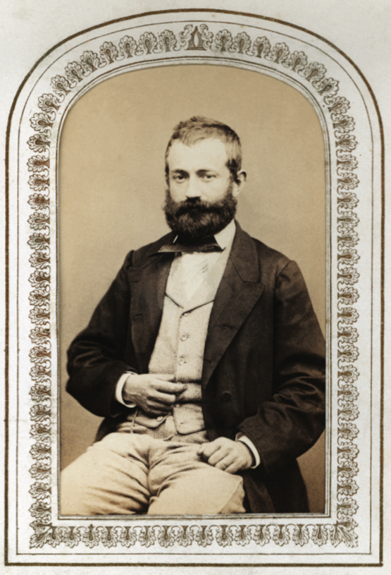
Vittorio Sella. Photo: Alpine Club Photo Library
The 1909 K2 expedition
Sella’s most important Himalayan photographs came from the 1909 K2 expedition led by Luigi Amedeo, Duke of the Abruzzi.
Filippo De Filippi’s official account of the expedition, Karakoram and Western Himalaya 1909 (published in English in 1912), was illustrated throughout with Sella’s images. Those photographs remain among the finest early records of the range. One of them, a telephoto view of Muztagh Tower, became famous far beyond the expedition report, and inadvertently sparked a legendary mountaineering myth.
Muztagh Tower and the photo
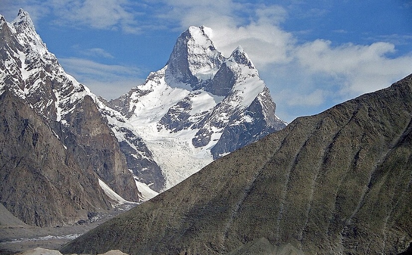
Muztagh Tower (7,276m) is located in the Baltoro Muztagh of the Karakoram, on the border between Pakistan’s Gilgit-Baltistan and China’s Xinjiang. It rises between the Baltoro and Sarpo Laggo Glaciers, just north of the main Baltoro corridor leading toward K2.
The peak has two summits only a short distance apart. The eastern peak is the true summit, and the western summit is a few metres lower. From most angles, the mountain is a substantial massif with steep but not uniformly vertical faces. From one particular viewpoint it collapses into something that looks far more extreme.
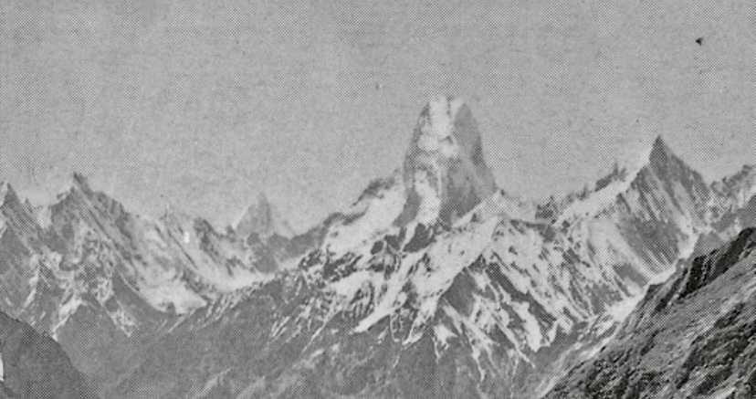
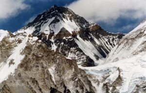
Muztagh Tower taken from the Upper Baltoro Glacier in 1919 by Vittorio Sella. The tower appears as an impregnable tooth. The photo inspired mountaineers for decades. Photo: Vittorio Sella
Sella took the image of Muztagh Tower from the upper Baltoro Glacier, looking northwest toward the mountain. The twin summits lined up almost perfectly. The long telephoto lens compressed the intervening ground and presented the peak as a narrow, knife-edged tower whose walls appeared to fall nearly vertically from summit to glacier.
From other angles the peak revealed broader ridges and less precipitous slopes, but this single compressed view was the one that circulated widely. The effect was really dramatic, but as later climbers discovered, also misleading. In 1941, Sella’s photo of Muztagh Tower appeared in a mountaineering book under the caption “The Last Citadel.” The image fixed the mountain’s reputation for decades.
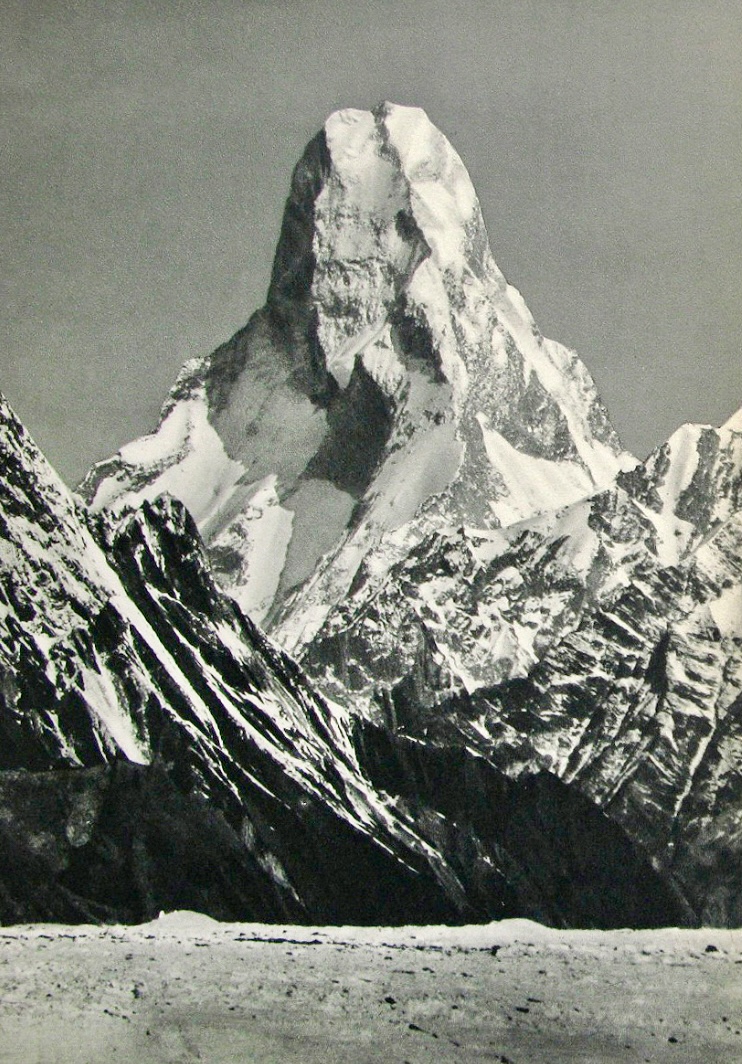
Muztagh Tower, 1909. Photo: Vittorio Sella
Two expeditions targeting the first ascent
In 1956, a British team and a French team both set out for Muztagh Tower, drawn in large part by Sella’s photograph.
The British team, led by John Hartog and consisting of Joe Brown, Ian McNaught-Davis, Tom Patey, and liaison officer Captain Riaz Mohammad, chose the Northwest Ridge. They planned to approach via the Muztagh and Chagaran glaciers on the western side of the peak.
The French party, led by Guido Magnone, included Andre Contamine, Paul Keller, Robert Paragot, Francois Florence, and liaison officer Ali Usman. They worked from the eastern side, aiming for what became the eastern arête after reconnaissance ruled out the North Ridge. The two groups operated independently on opposite flanks of the mountain.
The British ascent
The British established Base Camp on the Muztagh Glacier on May 28, 1956, at 4,282m. Through the first half of June, they placed camps on the Chagaran Glacier, avoiding the worst of the lower icefall by climbing the northern moraine and then threading seracs. Camp 3 was set on the west col at 6,355m after a steep ice wall. They reached the col on June 16, but took until the end of the month to move tents, fuel, and food up.
From there the route followed the exposed crest of the West Ridge, a mixed line of rock, snow and ice that required fixed ropes on the steeper sections. Brown made a key traverse around a rock cliff on the South Face. Camp 4 was placed on the ridge itself at 6,439m.
Above the high camp, the climbing continued up a narrow couloir and then mixed ground. The final technical obstacle was a short rock leaf between the two summits, graded alpine V and exposed on both sides.
On July 6, Brown and McNaught-Davis reached the western summit. The following day, Hartog and Patey, after supporting the first pair, crossed the connecting ridge and stood on the slightly higher eastern summit. Both pairs had to bivouac on the descent. Hartog suffered frostbitten toes. All four climbers reached the top.
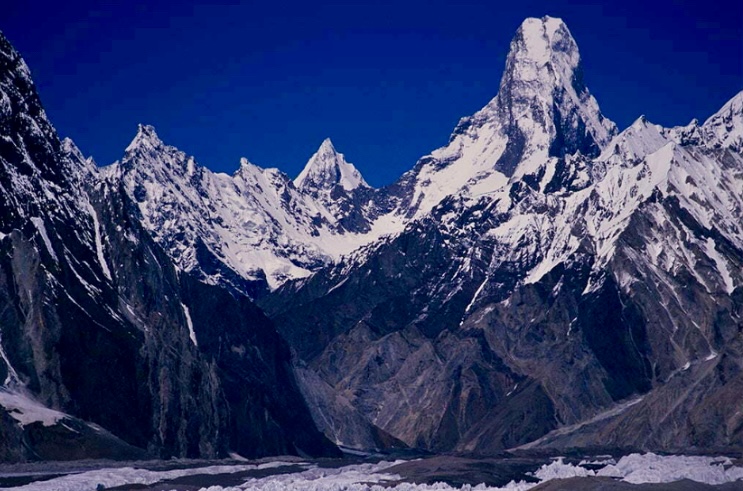
Muztagh Tower. Photo: Hunza Adventure Tours
The French ascent
The French established their Base Camp at 4,496m on June 12 after approaching from the Younghusband Glacier. Their reconnaissance quickly showed the North Ridge was impossible, so they moved onto the eastern branch of the glacier.
They fixed ropes through an icefall and up a rock-and-ice spur, placing successive camps until Camp 4 stood at the foot of the summit pyramid at 6,300m. On July 6, as bad weather closed in, they spotted the British climbers moving on the upper heights.
After the two-day storm cleared, the French regained the ridge, overcame two substantial rock towers, and bivouacked high on the mountain. On July 12, Magnone, Paragot, Contamine, and Keller reached the main summit through deep snow, six days after the British first topped out. After summiting, they descended to Camp 4 after dark. Dr. Florence had waited at high camp for more than 40 hours without radio contact during the summit push.
No bitter race
The British party therefore made the first ascent of Muztagh Tower. The French completed an independent second ascent six days later. Both teams discovered that the mountain, while technically demanding and exposed, offered viable lines. The route, while serious, proved less relentlessly steep than Sella’s photograph had suggested.
The two expeditions were not engaged in a formal competition. They approached from opposite sides, followed separate routes, and maintained cordial relations. The British simply reached the summit first. The French, seeing the British already on top, continued their own line to completion.
Far from a bitter nationalistic race, the two teams demonstrated alpine solidarity. The French team chose the east side specifically to avoid interfering with British progress on the western side. Rather than abandoning their push in defeat after spotting the British on the summit, the French celebrated their colleagues’ historic achievement and resolutely pushed forward to fulfill their own objective. When Hartog suffered severe frostbite during his descent, the French team stepped in to provide vital assistance and support during the evacuation.
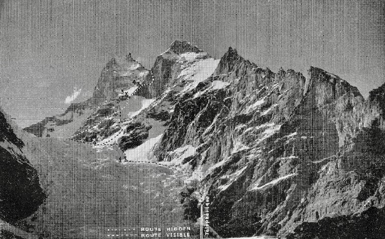
The southeast side of Muztagh Tower, showing the route. Photo: Guido Magnone for The Himalayan Journal
After 1956
Since 1956, Muztagh Tower has remained one of the least visited major peaks in the Karakoram. A British team in 1984 repeated the Northwest Ridge (Mal Duff, Tony Brindle, Jon Tinker, and Sandy Allan), though they reached the slightly lower west summit rather than the true east summit. In 1990, a Swedish party consisting of Göran Kropp and Rafael Jensen also successfully scaled the Northwest Ridge.
In August 2008, Slovenian alpinists Pavle Kozjek and Dejan Miskovic made a groundbreaking alpine-style push up the steep Northeast Face. They successfully reached the upper ridge crest, but ferocious winds ended their push. Tragically, just after beginning their descent, a ridge cornice collapsed, and Kozjek fell to his death.
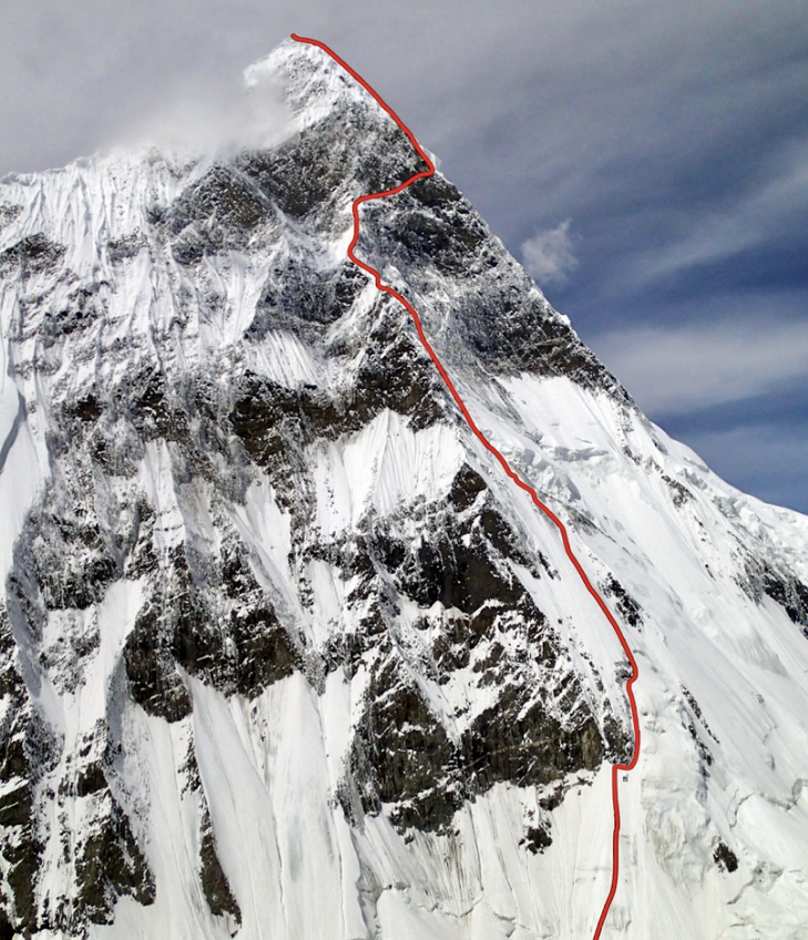
The 2,000m Northeast Spur of Muztagh Tower showing the line “Think Twice.” Photo: American Alpine Journal
Four years later, Russians Sergey Nilov, Dmitry Golovchenko, and Alexander Lange made the historic first ascent of the massive Northeast Spur. Their grueling 17-day climb via a new route named “Think Twice” reached the true summit, earning them the prestigious Piolets d’Or. The Russian team indicated in their expedition report that Muztagh Tower was 7,284m.
The 1956 French route has never been fully repeated to the main peak, and no further ascents of the true summit have been confirmed since the 2012 Russian expedition. Still, climbers continue to push limits here, most notably in 2019, with the first ascent of the Black Tooth (6,718m), a difficult lower spire on the mountain’s ridge.
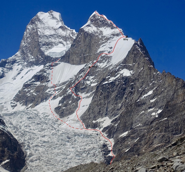
Muztagh Tower (top left) and its Southeast Ridge, with a high point on the Black Tooth (6,719m). The solid line, with the two marked bivouac sites, is the line of ascent to Black Tooth followed by Simon Messner and Martin Sieberer in 2019. Photo: Simon Messner/American Alpine Journal