In this series, we consider the 10 largest islands in the world from the perspective of an adventurous traveler looking for new possibilities.
Since there are no new continents to discover and a growing shortage of unclimbed mountains, modern adventurers often focus on lists. Projects involving or linking the 10 largest islands in the world are a great start.
Today, #3: Borneo
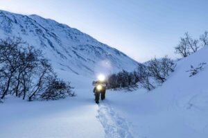
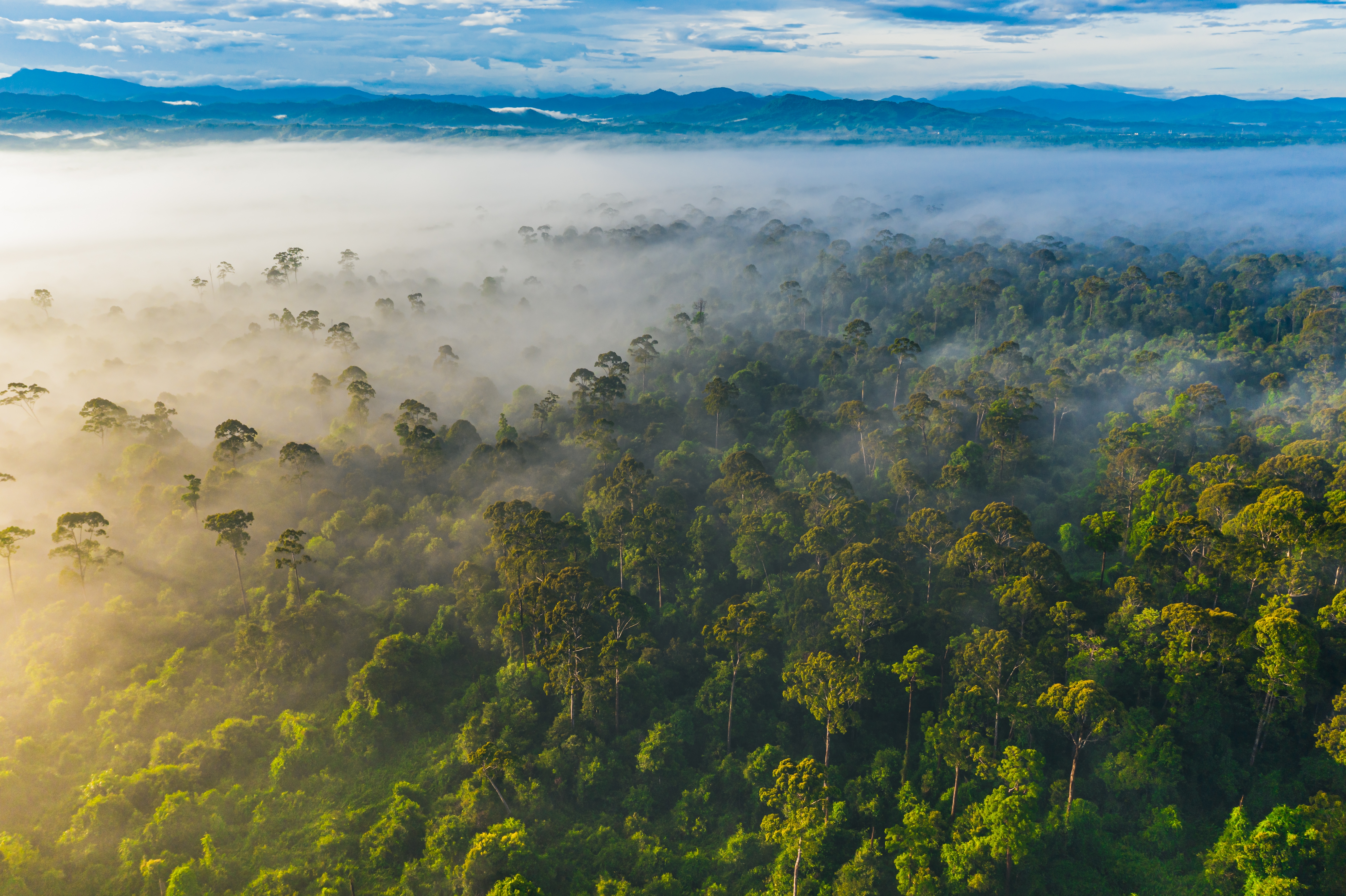
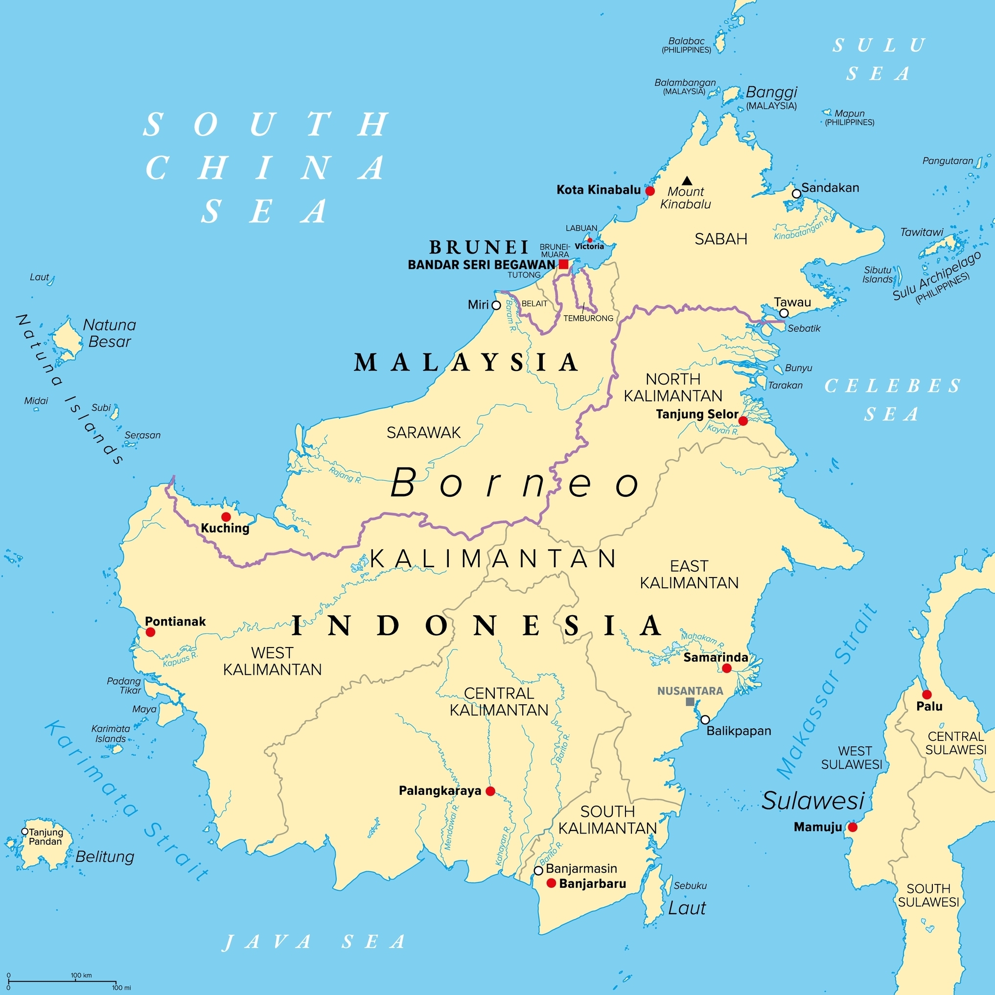
Split between Malaysia, Brunei, and Indonesia, Borneo is the third-largest island in the world. Home to the largest remaining tracts of the Sundaland rainforest, Borneo has also experienced great deforestation. Between 2002 and 2019, the island lost 5.8 million hectares of old-growth forest. It now covers only 28% of the island. In Malaysian Borneo, that percentage is even lower, roughly 20%.
Borneo is a major tourist destination, particularly for wildlife enthusiasts. The two Malaysian states of Sabah and Sarawak get most of the visitors. Kalimantan, or Indonesian Borneo, is less developed, while the tiny Sultanate of Brunei (covering just 1% of the island) gets the fewest visitors.
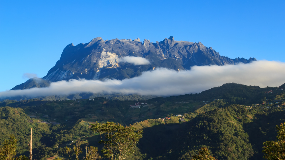
Borneo. Photo: Shutterstock
History
Europeans began charting Borneo’s coastline in the 16th century, but the interior remained largely unknown until the 1800s.
German explorer George Mueller made some early attempts to map the interior between 1818 and 1826, but was ambushed and killed by locals while on the Kapuas River in west Borneo, now West Kalimantan.
Further exploration of the interior coincided with competition between colonial powers, mainly the Dutch and the British. After receiving help to crush an uprising, the Sultan of Brunei granted British adventurer James Brooke the title of Rajah of Sarawak. Brooke set about fighting local tribes, already notorious in Europe as headhunters, and clashing with pirates along the coast.
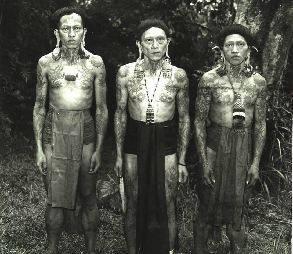
Dayak tribesmen, possibly from West Kalimantan. Photo: Michael Palmieri/Facebook
In 1863, his nephew, Charles Brooke (who later succeeded him as “White Rajah”), organized perhaps the first major European inland expedition. However, calling it a “European” venture is a stretch. The campaign used an estimated 15,000 local warriors, accompanied by just three Europeans. They marched up the Rajang River in Sarawak, destroying villages and forcing the local Kayan tribes to flee further into the interior.
Dutch explorers also pushed into the interior. Anton Willem Nieuwenhuis became the first European to cross the island from west to east in 1896-97. This was his third attempt at a major journey into darkest Borneo. Reports of dangerous Iban tribes halted both previous expeditions.
In 1896, Nieuwenhuis began in West Kalimantan and traveled overland to East Kalimantan. This filled in some of the last blank spots in southern Borneo. Nieuwenhuis didn’t say how far any of his expeditions traveled, but we can estimate that his third crossing covered more than 2,000km. (The straight-line distance between the west and east coasts is about 1,350km.)
Mount Kinabalu
Scientific expeditions into Borneo’s interior began around the same time. British naturalist Hugh Low traveled along rivers in both Sarawak and Sabah, cataloging plants and animals. In 1851, he climbed 4,095m Mount Kinabalu, the highest peak in Borneo, with local guide Lemaing.
This was the first recorded attempt at an ascent, although they didn’t summit. They only reached the summit plateau. Confronted with sharp granite peaks and without any climbing equipment, Low decided that the summit was “inaccessible to any but winged animals.”
Low also spotted a huge, glacially carved gorge on the north side of the mountain. He colorfully described it as “a horrible abyss, a veritable devil’s cauldron of incredible depth.” It later became known as Low’s Gully. It isn’t recorded whether the connection pleased him.
The 1,800m-deep gorge was the site of a major rescue in 1994, when a team of British and Hong Kong soldiers attempted to rappel into the gully. Five members of the party were trapped for 16 days, including five days without food.
Eventually, rescuers lowered stretchers from a helicopter to get them out. The first complete descent of the gorge came four years later, when mountaineer Pat Gunson led a large Malaysian-British team of 27. He remarked that getting the gear and supplies to their base camp was as hard as the descent.
In 1888, British explorer John Whitehead became the first European to reach the true summit of Mount Kinabalu, though it took him several attempts over three years.
Nowadays, Mount Kinabalu is a popular trekking peak. Tens of thousands of tourists summit each year, traditionally taking one of two well-worn trails to the top. However, in 2015, a massive earthquake killed 18 people and closed the Mesilau Trail option. That route remains closed, and all hikers now begin at the Timpohon Gate near the national park’s headquarters.
Mount Kinabalu. Photo: Shutterstock
The climb begins on dense jungle trails at 1,866m and only emerges onto bare rock some 800m below the summit. The climb is possible in a day, but most visitors stay overnight at a resthouse at 3,270m.
Kinabalu also features Mountain Torq, the world’s highest via ferrata. It starts at 3,400m on the Panalaban rock face and ends at 3,800m.
In the 1880s, British civil servant and zoologist Charles Hose led expeditions into Borneo’s interior “to extend administrative control, suppress intertribal conflicts, including headhunting, and collect…specimens.”
Hose used local guides and Dayak canoes to navigate Sarawak’s upper reaches. In 1905, he contributed 3,000 artifacts from Borneo to the British Museum.
Few expeditions since the 1980s
Although millions of tourists visit Borneo each year, the island has had few recent expeditions of note.
Perhaps the most famous modern expedition was American Eric Hansen’s 4,000km journey in 1982. Starting on the northwestern tip of Sarawak, Hansen walked and sometimes traveled by river, eventually arriving near the east coast in Kalimantan. There, confronted with the modern world after 137 days in the jungle, he promptly turned around and walked back. He covered roughly 2,300km on foot and another 1,700km on various rivers.
Hensen relied on the local Penan people — forest nomads who moved with food sources through the jungle — to cross the interior, both as guides and to source food. He traded objects, including shotgun shells and tobacco, for supplies and their support.
He wrote about his experiences in Stranger in the Forest, published in 1988.
Writers Redmond O’Hanlon and James Fenton made a similar journey on foot and by river into Borneo’s remote interior at around the same time. They didn’t go as far as Hansen, only covering a few hundred kilometers before turning around near the Müller Mountains. Like Hensen, O’Hanlon turned his journey into a book: Into the Heart of Borneo.
In 1982, American climbers Jim Slade, John Long, Rick Ridgeway, and Jim Bridwell made another (partial) crossing. They started in Pontianak, in West Kalimantan, and finished on the east coast in Tarakan, North Kalimantan, after 43 days. They did not always travel by human power: For example, they began with a three-day steamboat ride into the interior.
Ridgeway caught typhoid during the trek, and a missionary pilot evacuated him from a remote village. The team explained that they felt “fortunate to have gotten out alive and half well.”
The island’s geography makes human-powered crossings extremely difficult. Despite Borneo’s extensive deforestation, virgin forest persists in its rugged interior. The threat of tropical diseases, such as malaria and dengue fever, is ever-present.
Climbing
The mountains of interior Borneo offer opportunities for climbers, provided you can manage the complex logistics of setting up a base camp. In 2017, an Indonesian university team made the first ascent of Puruk Sandukui, a 1,023m tower that ends in a slim 250m spire. Also known as Index Finger Hill, it requires a multi-day journey from the nearest city, Palangkaraya. If it were more accessible, it would doubtless be a popular trad climb.
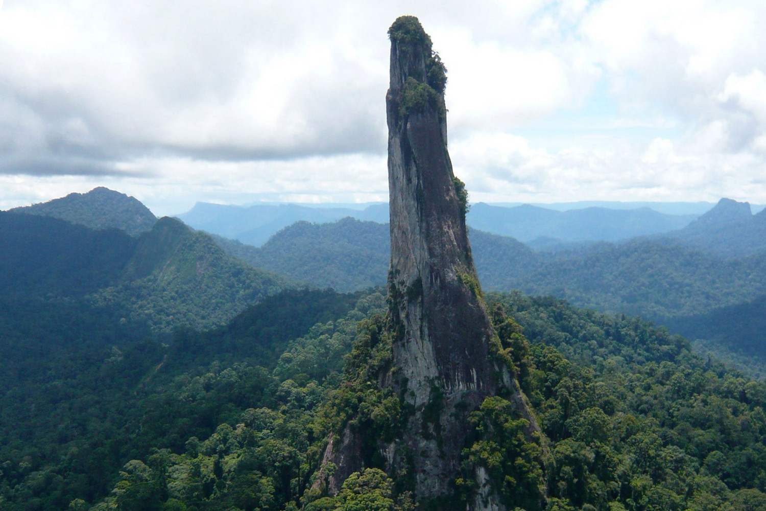
Puruk Sandukui in Central Kalimantan. Photo: The Crag
Paddling expeditions
There are no documented kayak or canoe circumnavigations of the island. This is unsurprising, given the enormous distance involved and long, exposed sections open to either the South Sea or the Celebes Sea. Other complications include the threat of kidnapping.
Several small islands off the coast of eastern Sabah have had problems with piracy, stemming from militant and terrorist activity in the Sulu archipelago. The UK government advises against all travel to the area. Finally, the monsoon means that adventurers can’t bank on long periods of stable weather.
Some inland rivers are well known for tourist rafting trips, but independent inland kayaking expeditions are uncommon. In 2022, a British Universities Kayaking Expedition headed to Seribu Riam in Central Kalimantan. The area translates as “a thousand rapids.”
Their journey is a good example of the difficulties of reaching the wild interior: “The journey from the east to the center, where we would base ourselves, was lengthy,” they explained later. “Two hours on a bus, twenty-four hours on a boat up the Mahakam River, and a ‘three-hour drive’, which took sixteen hours, followed by another four to finish.”
The journey was worth it, however. The team bagged six new first descents.
There surely remain plenty of first descents on the more remote rivers.
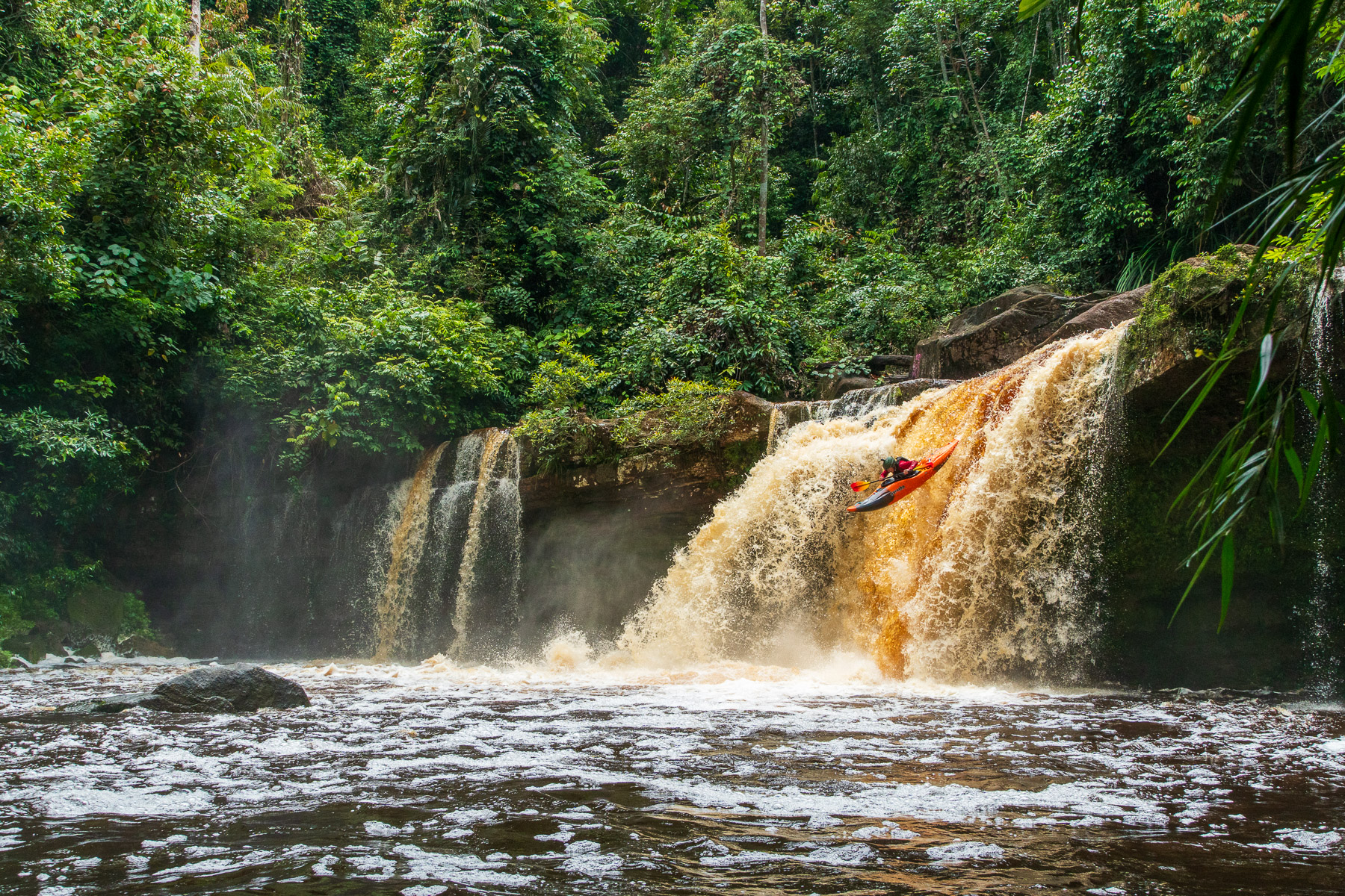
A kayaker during the 2022 British Universities Kayaking Expedition. Photo: NRS
Jungle tourism
Though major expeditions are rare, there are plenty of short, tourist treks. The most popular areas are in Sabah and Sarawak, including Danum Valley, Tabin, Mulu, and the Maliau Basin. Visitors can opt for multi-day hikes (accompanied by a guide) and might get lucky enough to encounter orangutans, gibbons, hornbills, and other iconic species.
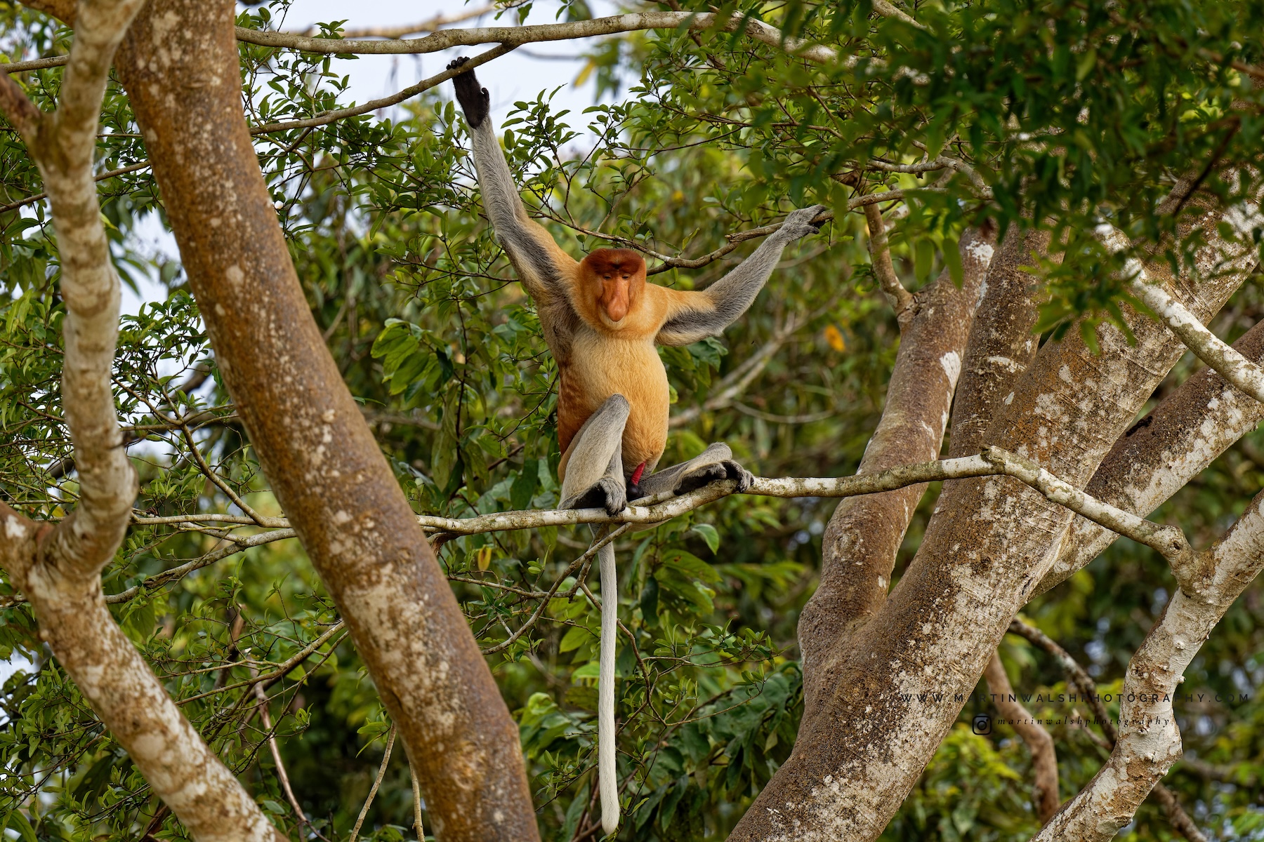
A male proboscis monkey in Sabah. Photo: Martin Walsh Photography
The UNESCO World Heritage Site of Mulu is of particular interest to cavers, with 295km of explored caves. Most of this cave system was mapped by teams from the British Royal Geographical Society, starting in the late 1970s. Their first expedition involved over 100 scientists and lasted 15 months.
The caves aren’t tapped out, either. A joint expedition in 2025 between Malaysian, British, and American cavers uncovered three kilometers of new caves around Gunung Api.
The area is also popular for trekking, with treks to the summit of Gunung Mulu (2,376m) and to the Pinnacles on Gunung Api, a collection of limestone spikes. Both hikes are reportedly much harder than climbing Kinabalu.
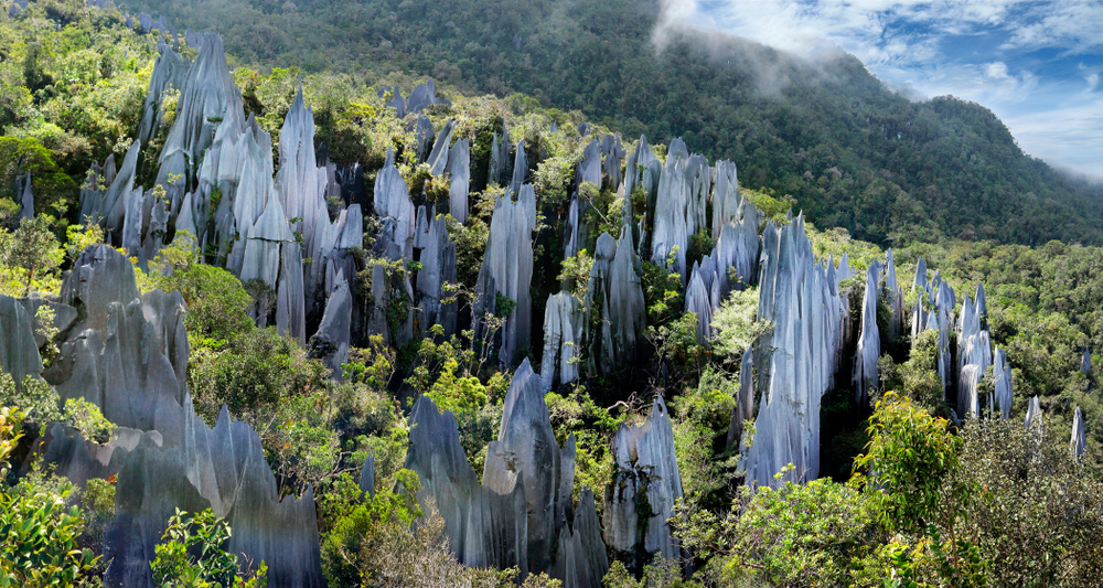
The Pinnacles in Mulu National Park, Sarawak. Photo: Shutterstock
Finally, a “Cross-Borneo” trek takes tourists from near the coast of East Kalimantan along the Muller Mountains and deep into the interior, finishing near Indonesia’s border with Malaysian Sarawak. This is usually a 16-day journey, although only six or seven days involve hiking.
Previous stories in this series: